Gumbies

Tuesday, May 31, 2005

ascent


ascent, originally uploaded by amakusavibe.

The going was slow at first. Brushy vegetation is quickly taking over the lower slopes of the volcanic cone and we had to push through with effort, scratching up our bare legs. Higher, the brush gave way to grasses and rocks, and finally there were only bare rocks. Typically for a volcano, the talus boulders were unstable, often shifting under our weight, and the scree was like walking on ball bearings. Care was required not to start a rock avalanche or pull a boulder down on oneself, but it felt like climbing a much taller, alpine mountain and we became quite excited. Hot steam hissed forth from the rocks around us as we climbed higher. By sunrise we were climbing the last few rocks to the summit.

azaleas_mountain


azleas_mountain, originally uploaded by amakusavibe.

It was still early morning when we reached Fugendake, somewhat relieved that no one was around this Monday morning even though the famous azalea bushes were fully abloom and it was the height of hiking season. Neighboring Kunimidake had the best display of color. Below, the morning’s first tour bus was seen straining up the road to Nita Pass, and soon after the Myokendake cable car began circulating busily.

ashiyu


ashiyu, originally uploaded by amakusavibe.

The sun was baking down already as we coasted down the mountain on our bikes. Not really tired, we climbed up the newly opened Mayuyama Road back up to our car. We spent the afternoon sightseeing lazily around Shimabara, an interesting little city with a walled castle, a samurai street and houses and a free hot spring footbath, which felt great in spite of the afternoon heat. A sign above it said the water was good for healing cuts, so we splashed it all over our roughed-up legs and forearms. It stung quite a bit.

Tuesday, May 10, 2005

TSUSHIMA CIRCUMNAVIGATION

tusima_over
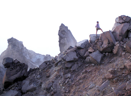
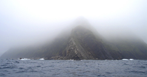
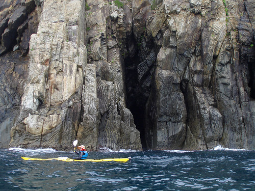
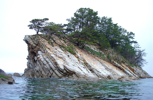
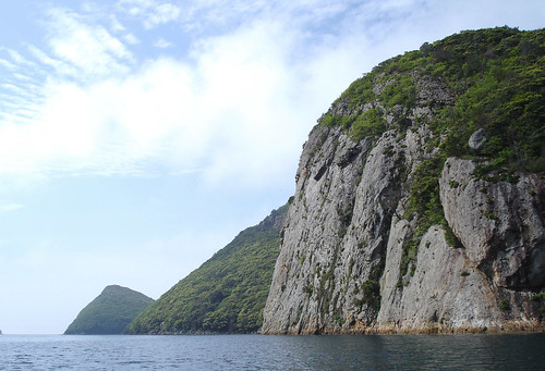
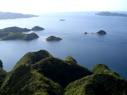
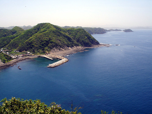
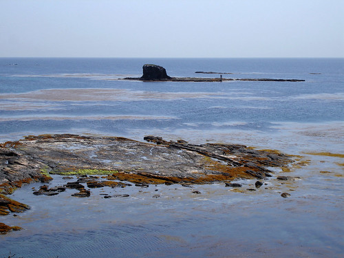
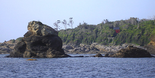
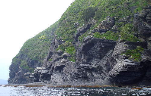
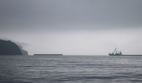
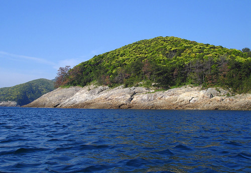
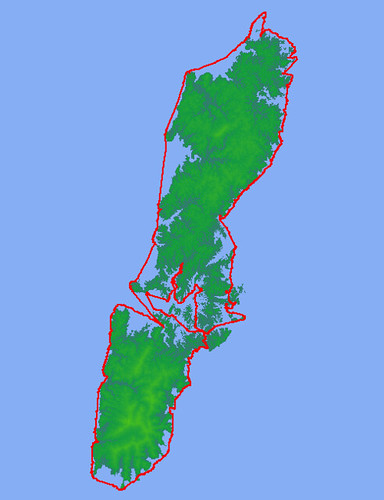
With the Korean Peninsula close to the north, the large Japanese island of Kyushu to the south, the East China Sea to the west, and the Japan Sea to the east, the Tsushima archipelago does not enjoy a very stable position, be it from the point of view of weather, sea currents, or even human civilization. Storms descending from the Asian continent batter the islands with cold winds in the winter and spring, and typhoons that have not yet lost strength by encountering land occasionally blow in from the south-west during summer and fall. The waves and tides of the two seas don't often match, creating confused currents and rips around the exposed points of the coast. The civilizations on either side have not exactly mixed well either, and although for a time Tsushima was an important trading point between China and Japan, there were also territorial squabbles and today the coasts are heavily patrolled by the Japanese Coast Guard and Self-Defense forces. With South Korea's coast less than 60km away, the northern tip of Tsushima is one of only three points where foreign land can be seen from Japan, and this seems to make the authorities uneasy.

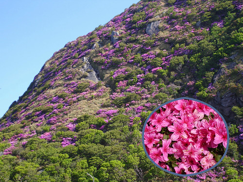
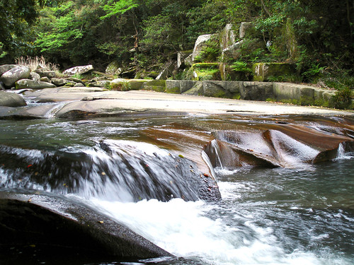
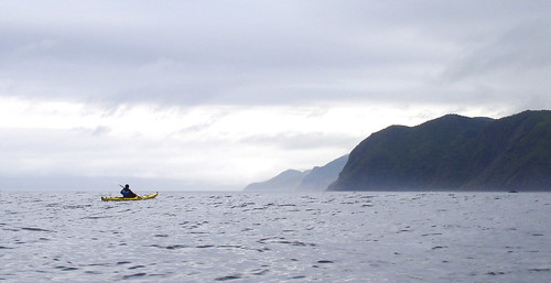
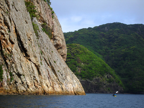
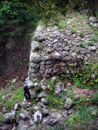
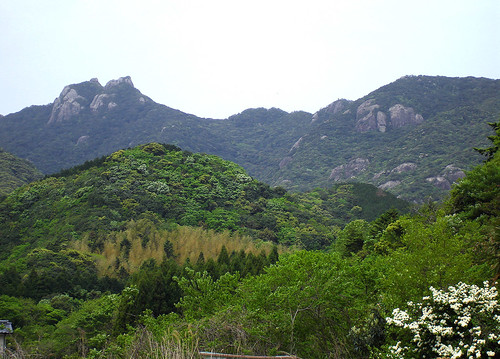
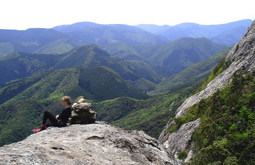
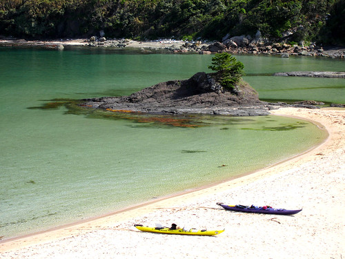
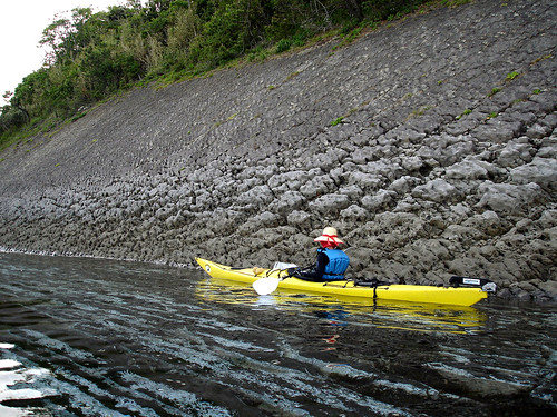
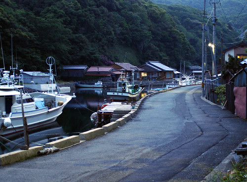
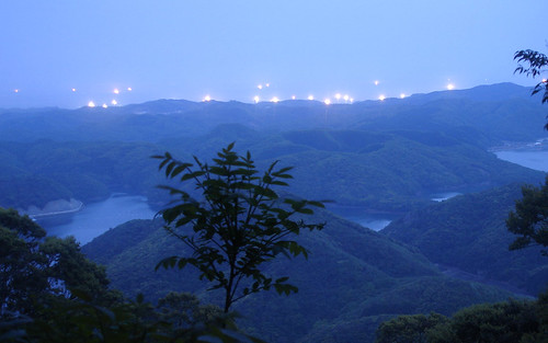
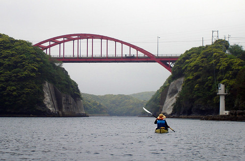
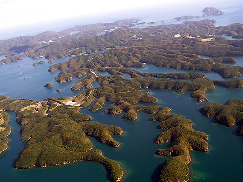
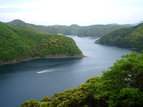
For the casual explorer, these facts make Tsushima an interesting place to visit. Loosely translated, the first week of May is called in Japan 'the big string of holidays' and this year for most folks this amounted to three days off during the middle of the week (with work on Monday and Friday). During this time certain places recognized for their sightseeing value get jammed beyond belief by visitors with exactly synchronized schedules. Such places are prudent to avoid, but others, equally scenic, remain just as deserted as ever. This year we were lucky to get 10 days off work and gambled on Tsushima to be in the latter category. We were not disappointed. We planned a tour circumnavigating the archipelago, covering a distance of about 250km; this is very reasonable in 10 days if the weather cooperates, but we weren't counting on that. Fortunately, due to the elongated shape of the islands, in bad weather usually only the west or the east coast becomes unnavigable. In the middle, a sheltered bay called Asou-wan exists, as well as two very narrow passages linking the two coasts. With this strategic information, a long-range weather forecast, and, we hoped, a little luck, we planned to travel always sheltered from the storm.

fog


fog2, originally uploaded by vibromama.

Travelling at night from Fukuoka by freight boat, it was hard to ascertain the condition of the open sea. Arriving in Izuhara, Tsushima's largest town, with hours left before daybreak, we searched in vain for a ramp in the harbor. The sole employee of the shipping line still awake at this hour was not very helpful. He could not fully grasp what we were about to do, and only succeeded in increasing our worries by painting a truly grim picture of what the seas are like outside Izuhara's sheltered harbor. He would not even budge from his chair to drive our boats, still loaded on a truck, to a nearby place where we might put them in. Eventually, we carried the boats ourselves and launched them with some difficulty at a set of steep steps on the pier, and set off into the misty, uncertain dawn. Getting out of the harbor, we saw the seas were not that bad after all, although visibility was limited in mist, drizzle, and a very low cloud ceiling.
nain
Seeing the steep coast stripped to bare rock and hollowed out in caves to a height of 15m or more, we understood that the sea was really only resting today. Landing spots were very few, and moderate sea currents, seemingly out of synch with the tide schedule, were felt around the projecting capes. We moved cautiously onward, making the occasional landings at an isolated beach or a seaside shrine, and by noon we had rounded the southern end of Tsushima. A south-west wind had produced some swell on the western side and we rode this a short distance north to the tiny fishing port of Sasuse, where we decided to camp on top of the concrete ramp beside some stinking scum-covered nets that had been laid out to dry.

ayumodosi


ayumodosi, originally uploaded by vibromama.

Since it was still only early afternoon, we went for a walk up the Segawa River to a place called 'Ayumodoshi' or, 'where the Ayu fish turn around'. The Ayu is a kind of trout that inhabits the lower reaches of Japanese rivers (there is a famous Japanese-English joke that goes, 'Ayu a fish?' - go figure). Ayu generally cannot move upstream past major rapids, so many rivers in Japan have a place named something similar. This Ayumodoshi turned out to be a pleasant enough place with a small waterfall and a scenic section where the river sculpted its course into the sandstone bedrock. We walked a bit further upstream, to find a ludicrous, but to us no longer surprising sight: a would-be tourist attraction park complete with dam, suspension bridge (an absolute must at this kind of place, it seems) gazebos, walkways...it is doubtful there will ever be enough tourists here to enjoy all this (the place being deserted now, at the height of tourist season). Yes, it's just another wasteful construction project. We cut uphill through a barren mini-golf course, aiming at the trailhead for Taterayama, one of the higher mountains of Tsushima. Taterayama has a protected area of 'primeval forest'. Thankfully, big old trees resplendent in the new verdure of spring soon surrounded us. What a relief!

west coast


wcoast, originally uploaded by vibromama.

Heavy rain and wind started just as we made it back to the port. We were grateful for the clean, flat, well-drained concrete surface as well as the special typhoon-proof wind-blocking walls guarding the breakwater. In the downpour the stink of the nearby nets had more or less washed away, but our well-used tent leaked and so we were soon quite wet. Nevertheless we spent a reasonably comfortable night while the storm raged on outside. (Unknown to us at the time, in our home islands of Amakusa 250km to the south it would cause landslides and wipe out the scenic west-coastal road.) By morning,
however, things had calmed down a bit and we continued up the west coast, with a fresh wind and surfable swell astern. The coast here was no longer so majestic as the southeast coast yesterday as soft sedimentary layers replaced the solid igneous rocks somewhere in the vicinity of Tsushima's southernmost point. Still, we were happy to be here, and happy that the sea had remained navigable after last night's storm.

siine


siine, originally uploaded by vibromama.

Our next stop was the scenic hamlet of Shiine where one can see, if one can believe the local tourist info, the only stone roofs in Japan. A short walk from the port takes one to the village where a few stone-roofed houses are preserved, as well as many more with conventional roofs but similar wooden structure underneath; a design that we would see in many other places on these islands. Compact, modest, and windowless, with thick wooden beams and pillars supporting the heavy roofs, the houses seem to evoke harsh living conditions of the past. This impression is made stronger when these dwellings are compared with Tsushima's modern houses - real mansions by Japanese standards: huge, spreading and, it seems, furnished preferentially in Western style. We were scratching our heads about both of these architectures, wishing we knew more about Korean ways of doing things to see if there is any influence. The mansions, we figured, were there because land must be cheap here in as rural a place as can be found in Japan. The rest of the story was filled in later when chatting with the locals: a generation or so ago the pearl business boomed for a short time and Tsushima, with its large cultured pearl farms, prospered briefly.

island


island, originally uploaded by vibromama.

With fog still obscuring much of the coast, we rounded Gouzaki, the southwest gatepost of Asou Bay. Obediently, the sea calmed down to nearly mirror smoothness. Visibility was limited so we set a GPS course eastward grazing several isolated rocks and tiny islands. Some, including Maguwa-jima pictured here, seemed to be edges of great inclined plates of layered rock just barely projecting from the sea surface, as if the plates were once floating on the sea, but then tipped over and nearly sank.

nokowaki

nokowaki3.

The weather suddenly lifted as we approached Nokowaki-iwa, a large rock cliff dropping vertically into a fjord-like inlet. This is a very popular place to visit by boat, and now that the air was clear we could see that the place is indeed quite scenic. Two yachts cruised by (by motor, of course; we never seem to see a sailboat actually sailing) but no other kayaks were seen today or any other day on this trip, for that matter.

nokowaki2
We were excited because the cliff seemed to be of rock-climbing quality. Examining it carefully, we saw no trace of bolts, pried off flakes, or any other hint of established routes. Could it be that this cliff is still virgin territory? For better or worse, a number of moderate routes could be established on its 50-70 meter face.

shrine


shrine3, originally uploaded by vibromama.

On the opposite shore of the inlet, there was a shrine gate. Looking for a place to camp nearby, we put ashore. To our surprise, a trail led into the Jou-yama Mountain from here. Having planned to climb Jou-yama to examine its castle ruins but not being sure what part of the shore to strike out from, we were pleased such an easy solution had presented itself.

Afternoon sunshine was rapidly dissolving the last shreds of mists clinging to the forest surrounding the shrine. Everything was quiet and peaceful.

castlewall


castlewall, originally uploaded by vibromama.

The Kaneda castle, which once stood on Jou-yama's 270m tall summit, was built, it is said, in Korean style. We're not sure exactly what that means, especially since the castle is completely gone now, and the ruins that can be seen today are of a WW2 artillery installation. The most interesting thing that still remains is the wall that once surrounded the castle. The wall wraps around the mountain and is several km long and about 5m high - a major piece of work. Perhaps the Korean style of doing things was putting fortresses on remote, steep peaks and surrounding them with substantial defenses. The Japanese castle, in comparison, seems to be just a spiffed up palace for the residing lord, situated on a comfortable, small hill in the middle of a city, and rather lacking in defenses. Indeed, historically Japan's military conflicts tended to involve battles fought far away from the centers of control and once a battle was lost, there was usually nowhere defensible to run to and hole up for the loser (they were usually killed outright or managed to hide for a while in the mountains). This was, incidentally, also true for Japan in WW2, as the Japanese archipelago remained undefended while its navy overextended itself all over the Pacific Ocean.

joyama

joyama.

From the top of Jou-yama, there is a great view of the Asou Bay area, and we were able to see the string of islands we had navigated earlier that day in the fog.

Commanding the bay and the narrow straits that divide Tsushima into two main islands, one can see how such a spot was important strategically in times of conflict.

siratake


siratake4, originally uploaded by vibromama.

The following day, we were anticipating strong winds yet clear weather. Although traveling within Asou Bay seemed possible, we used the day for hiking Shiratake, possibly the most interesting summit of Tsushima.

siratake


siratake1, originally uploaded by vibromama.

Shiratake ('White peak') has cliffs of white rock armoring its summit, and a primeval forest is preserved on its slopes. It was a pleasant hike and the view from the top was wonderful. However a 20-knot northeast wind was blowing on the summit and huge waves crashing into the rocks on the east coast were visible through our pocket telescope.

The wind was calming down by late afternoon when we returned to our boats, and we put in and headed west again. About 2 hours later, we were at Karasu-zaki, the northwest gate of Asou-wan, and entered the open sea once more just as the sun was setting. Aiming to camp at Ikeda beach just around the corner, we were surprised to learn in the quickly gathering darkness that the beach was actually composed of large boulders and concrete tetra pods, and thus was completely unsuitable for camping or even landing. However, we soon found a gravelly spot to land and an OK spot to camp by the road on top of the seawall. Later, the error in our research became obvious: Ikeda beach is not known for swimming, but rather for a stone wall that had been since a very long time ago, keeping back the frequently violent sea.

kisaka


kisaka, originally uploaded by vibromama.

The following morning we continued making progress up the west coast under bright, sunny, and nearly calm conditions. We floated by Tsunashima, a group of small-uninhabited islands. The vegetation and wildlife on these islets are also protected. They did not seem too unique as we passed them by, however. The coast itself was steep with many bumpy, low hills made of soft rock, a condition that continued more or less all the way to Tsushima's northern extremity. The nearby inlet with the town of Mine at its head was visibly polluting the water; and some more pollution can be seen in the foreground of this picture issuing from the tiny town of Kisaka. Like in Amakusa the extent of such pollution can be seen clearly on any calm day. Of course we had no reason to expect Tsushima would be somehow ahead of the rest of Japan in the application of sewage treatment.

mogoya


mogoya, originally uploaded by vibromama.

On the shore at Kisaka one can see the 'mogoya', old stone huts that were used for storing dry seaweed, which was then eaten and/or used as fertilizer on the nearby fields. The roofs of the huts are of course new, and the surrounding grounds have been converted into a picnic area. A perfect place for camping, but it was still too early so we moved on north.

saozaki


saozaki, originally uploaded by vibromama.

Moving at a sprightly pace we covered the next 20km in less than 4 hours, arriving at Saozaki, the northwest cape of Tsushima, an hour before sunset.
Unexpectedly a great little picnic area presented itself for camping just around the cape. We knew that two artificial beaches with full facilities exist a little further on, but we liked the place so we decided to stay the night.

At sunset I went fishing, letting myself drift toward Korea on the current for a while, but with no luck.

yamaneko

yamaneko and crew copy.

The night was to prove eventful. Discovering we had left our pots at Ikeda beach while packing the morning before, we had no means to cook dinner. Although we could have stuffed ourselves with our ample supply of 'Calorie Mate', a kind of Japanese Power-Bar, we decided for no good reason to walk to the nearby town of Sago. It would have been much faster by boat, but we walked anyway, not really sure what we were expecting to find (instant Ramen at best?). The road wound lengthily up and down the hills and the lights of the town seemed few, dim, and far away. In the hills it was totally dark. Suddenly a van came up the road and stopped beside us. The driver, looking distraught, told us we mustn't walk here with sandals since there are many vipers. I've heard this kind of talk many times before, but the vipers are not nearly as common as they say; though it is always good to be cautious. Nevertheless Mr. Yamamura, the nice man, insisted to take us to his house and donated one of his own pots after learning of our predicament. As we were driving back into the hills, Yamamura-san casually asked if we wanted to see a 'mountain lion'. He explained he was going to feed the rare Tsushima mountain cat, as he had been doing every night for the last 12 years! We were delighted to tag along, and were treated to a show of not only the cat but also a Tsushima-Ten, a weasel like creature that the cat does not get along with very well, hauling off large pieces of raw chicken. As there are less than 100 wild cats left in the wild, we felt very privileged to see one of them. Perhaps the idea of feeding them seems odd, but Yamamura-san explained that due to the destruction of their habitat, their natural food source has all but disappeared and feeding them seems necessary if they are to survive. We were deeply impressed to see that someone cares enough about the environment to do such dedicated work at one's own expense. More people like Yamamura-san are needed in Japan.

mitusima


mitusima3, originally uploaded by vibromama.

A light current and tailwind the next morning helped us on our way to Mitsushima, the northernmost point of the archipelago. The current quickened as we approached, and we rode through several sets of moderate tidal rapids. Had the weather not been so calm and settled, these interesting islets, rocks and shoals would not have been easy to reach. As it was, under nearly calm conditions, nature did throw us one surprise: the current ran the opposite way from what we expected. Even now it's unclear to us how the Sea of Japan, a sizeable but nearly land-locked sea, can have water streaming into it while its level is dropping, and vice versa. Anyway, this surprise turned out to be to our advantage since we originally expected to current to be against us.
mitusima1

Landing on the largest islet we loitered for a while around the lighthouse enjoying views of the shoals exposed briefly by the ebb tide. The scene looked strangely quiet and peaceful. Departing, we enjoyed looking through the calm surface of the crystal-clear sea onto the multicolored rocks and seaweeds in the shallows below us, and among them numerous fish and other creatures of all shapes and sizes going about their busy lives.

hitotubatago


hitotubatago3, originally uploaded by vibromama.

Returning to the coast we changed course unexpectedly, attracted by a large greenish-white patch on the coastal mountainside. Coming closer, we realized the whole mountain was abloom with a thick, white blanket of flowers. These trees are called 'Hitotsubatago' and for some reason grow very thickly on the hillsides around the tiny village of Waniura ('Alligator Bay'). As luck would have it the village was just having its yearly Hitotsubatago Festival, and we even witnessed 'Nanjamonja', the local dance performed by a dozen or so costumed ladies of the village.
This was the only place on our trip where we saw anything that could remotely be called a crowd of tourists, though most seemed to be locals from the neighboring towns coming to enjoy the small celebration.

miuda


miuda, originally uploaded by vibromama.

Miuda Beach lies on the east coast about 7km southeast of Mitsushima and is supposedly one of 'Japan's 100 Best'. Arbitrary as such a designation may be, the beach is nice because it was not over-developed, though a stone's throw from it is Tsushima's best-known onsen, or hot spring, in a compound surrounded by an array of boilers fed by a power line sturdy enough to serve a whole village. Authentic or not, it felt good to wash and soak our bodies in something other than seawater.

sentakuiwa


sentakuiwa, originally uploaded by vibromama.

Further down the coast, near the town of Hidakatsu (the second most important port in Tsushima, also with fast ferry service to Fukuoka and even Korea), is the Renkon-Sentaku-Iwa, or Washboard Rock. One of several such rocks scattered around the archipelago, it is the product of marine erosion of sedimentary rocks whose layers have been tilted over the eons by tectonic forces.

Tomigaura


village, originally uploaded by vibromama.

Little port towns such as this one hug the numerous coves and inlets of Tsushima's east coast.

squidboats


squidboats, originally uploaded by vibromama.

Squid fishing is the main industry here, and boats leave port in the late afternoon for the off-shore seas, where they fish overnight using an array of powerful lamps to attract the squid. Viewed from a mountain, their many bright lights seem to float on the horizon.
Yet, their number has been decreasing in recent years, along with the number of squid. Probably, drastic over-fishing is taking place here much like all over the rest of Japan. Ironically, the dried squid snacks available in local shops and even tourist traps, touted as Tsushima squid, all seem to originate from China, as can be verified from the small print on the backs of the packages.

shrine


shrine1, originally uploaded by amakusavibe.

Shrines accessible only by boat dot the shoreline here and there, reflecting the local people's dependence on the sea. They give the coastal scenery a decidedly oriental flavor. Reflecting the more or less pagan Shinto tradition, they are built in locales thought to be inhabited by the various natural gods. As such, they make for interesting stopping points for the itinerant kayaker, though landing on the rocky shoreline is not always easy.

fog

kurosima1
With the weather again descending upon us, we were glad to turn the wild, rocky coast of Kuroshima and enter the docile Miura Bay.

fog1, originally uploaded by amakusavibe.


Improving upon Kuroshima's natural weather-blocking position, a construction ship is seen busily closing off the mouth of the bay with a concrete breakwater. When this job is done, Miura Bay will be calm as a pond even in a typhoon.

manzeki


manzeki, originally uploaded by vibromama.

Only about 50m wide, Manzeki Seto is the main passage linking Tsushima's east and west coasts. A violent current usually rips through this unlikely channel while ships seemingly too large to pass squeeze through; it is not always safe or even possible to get through in a kayak. However, this evening we were whisked through by a fast yet smooth current, and saw no boat traffic. In just a few minutes we were on the other side, in the expansive Asou Bay.

bay


aou_air.

Asou Bay is the most popular kayaking destination in Tsushima, and no wonder, what with its innumerable coves, inlets and passages. It is a docile place, navigable in nearly all weather. Tidal currents are weak here since the bay is nearly closed off on the east side, and has a wide mouth on the west. One could spend a couple weeks here alone, exploring all these nooks and crannies.

Today, with a steady 17-knot wind blowing from the north, the open seas would have been unfriendly indeed. It was getting hard to believe our constant good luck as we paddled a circuitous course within the safe confines of the bay.

bay, originally uploaded by vibromama.
One would have to taste the water to know this is really the sea; the scenery reminded us strongly of the inland lakes in our home Canadian province of Ontario, where we had on occasion paddled around in a canoe.

watazumi


watazumi, originally uploaded by vibromama.

The Watazumi shrine is possibly Tsushima's best known, and the torii gates placed in the sea remind one of Miyajima in Hiroshima Prefecture. Watazumi lies near the end of a long inlet extending northward from Asou Bay; the detour proved worthwhile since in the next cove, we discovered a comfortable new campground. Generally we prefer to camp wild and free, and fancy campgrounds in Japan often charge per night what one might pay for a cheap hotel, but the Japanese only camp and sunbathe 'in season' which is approximately the middle two weeks of August. The rest of the time, camp and beach facilities are deserted and unmanned - ideal loitering points for the opportunistic kayaker.

ebosi


ebosi1, originally uploaded by amakusavibe.

From Watazumi one can also easily climb to the 176m tall summit of Eboshi-Dake, and enjoy a panoramic view of Asou Bay.

bindama


bindama, originally uploaded by vibromama.

After scouring Japan's flotsam-strewn coasts for many months, today we finally found a 'bindama': a glass-ball float from the olden days. Used extensively in for farming and fishing, they are now made of the ubiquitous (and ugly) plastic or Styrofoam, like the ones in this pearl farm. We were delighted by our find but it was too big to fit in the kayak, so Leanne carried it on her lap for the rest of the trip. Surprisingly, the bindama does not interfere much with paddling - if one's technique is good.

Where are the pots?


pots, originally uploaded by amakusavibe.

Being fairly close to the spot where we had forgotten our pots earlier, we embarked on a little hike to recover them. "There they are!" exclaimed Leanne when we arrived at the scene, but it took me a while longer to locate them among the jetsam-strewn boulders. Can you see them? Sadly, this is a rather typical sight in Japan, be it mountain roadside or seacoast. Maybe someday people here will learn to respect the environment more.

simoneo


simoneo, originally uploaded by amakusavibe.

The following day we exited again onto the east coast through a passage
called Oofunakoshi. This time, we had to face the current with a some
sprightly paddle strokes and a couple ferry glides back and forth across
the narrow strait. Exiting into the open sea rather suddenly, we turned
south again. Nearing the completion of our journey, the coastline again took
on the wave-swept, rocky aspect we noticed at dawn of our first day. The
weather today was clear and bright with a 18-knot north-west wind. Our great
luck with the weather was complete; buffeted by occasional gusts of wind we
tried to imagine what the west coast looked like at that same moment.

sunset


sunset3, originally uploaded by vibromama.

Dry for the first time in ten days, our skin felt uncomfortable that afternoon as we sat on the windswept deck of the ferry and watched Tsushima receding into the hazy distance. To the south, Iki-shima came into view with its low hills and long, sandy beaches, and on the opposite side one could just make out the lone, isolated cone of Oki-no-shima. A scattered flock of seabirds had no trouble at all keeping up with the speedy ferryboat for hours, effortlessly following the curves of the waves with their wingtips and riding on the invisible flow of air just above the water. To traverse this kind of distance in a kayak would surely take some effort, but having done no long open crossings, it was hard to imagine what it would feel like. By seven o'clock we had entered the busy Fukuoka harbor, and watched the sun set among islands and ships cluttering the water. Another journey had come to and end, and we felt happy and fully alive.


Subscribe in a reader
[View Guestbook] [Sign Guestbook]