Kamifukune-yama
The other weekend we made another day trip into the Kyushu Central Mountains, our favorite mountain exploring area. It was a fine day, clear, temperature in the 20s, such as we’ve been having continually for nearly a month now. Besides exercise and relaxation, our excursions here are also part of an ongoing project to thoroughly map the trails of this wilderness (no decent hike map of the whole area exists). The route of the day was a traverse of Kamifukune-yama, at 1645m one of the higher summits in the range. We would spot the car and bike around the mountain first to get into position.
In order to avoid the masses of slow vehicles that flood Japan’s roads as soon as it’s light out, a 4am start from Hondo was necessary. By 6:30 we began the 1000m climb that is required to enter the hills from the north. It took well in excess of another hour on very narrow, twisty, and half washed-out roads to penetrate only 14 linear kilometers into this labyrinth of steep-sided ridges and deep valleys, and reach what would be the exit point of our hike. Here we assembled our bikes and down the hill we went.
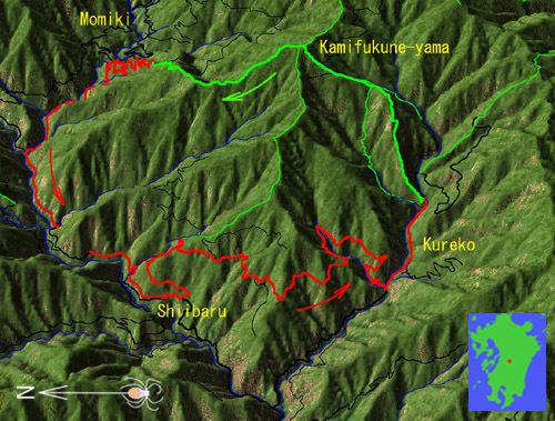
A simulated aerial view shows our bike/hike excursion around and over Kamifukune-yama, in the Central Kyushu Mountains. Our biking track is the thick red line (23.5km long, 1100m climbing), hiking is thick green (8.2km, 1060m). Black lines are other roads (thick=paved, thin=dirt), and thin green lines are other hiking trails.
The village of Shiibaru, where we soon found ourselves, clings to the slope in an unlikely part of the claustrophobically deep and narrow Kawabe River. Here we were presented with an interesting option: rather than following the valleys, we could discard common sense and reach our trailhead via a new road that instead climbed pointlessly into the mountain, only to drop precipitously again after contouring across several ridges. At its starting point, a sign announced with an air of carefree happiness: “A road connecting mountains and villages” without caring to specify further. Luckily we knew the road could take us where we wanted to go. But just beyond was a less joyful notice: closed to all traffic due to typhoon damage. Oh well, we can probably get through, we thought, and began huffing up the hill, full of morning energy.
This road stands as a good example of the utter nonsense that is modern Japanese infrastructure construction. To start with, why spend a millions of dollars to build a road that in 10.8km of length, climbs 460m into the mountain, only to go back down again, when a much straighter, 6.4km option that climbs only 150m already exists? This to connect two villages of perhaps 100 inhabitants each? Futhermore, because of the constant threat of landslides on the steep mountain slopes, the road is certain to be damaged almost every year. The answer to this riddle lies well hidden somewhere within the country's convoluted politics; suffice it to say that ultra-conservatism and corruption play a major role. It is perhaps not an accident that it's happening primarily in remote regions out of reach of the average citizen's eye. The same citizens pays for it dearly along with Japan's environment: daily, practically irreparable, and completely unnecessary damage.
Impossible roads
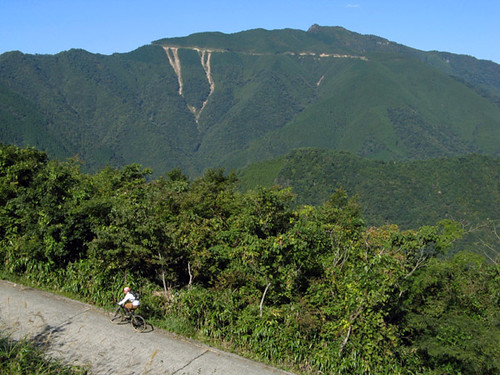
As we tackle the steep climb, we are presented with a view of a road similar to ours, contouring impossibly above on the opposite slope of the valley (indeed nearly every visible mountain seems to already have one). Numerous landslides have started from the road scar – tears of the mountain weeping. The slides threaten the valley below, but no worries, the engineers will probably compensate with some monstrous (though finally ineffective) concrete barrier somewhere lower down. Cresting the summit of our road, we begin to descend headlong toward Kureko Valley. Soon we find the cause of the road closure: a massive landslide, likely due to the road cut itself, has completely wiped out a section; this is now being replaced by a kind of bridge on concrete supports. We say hello to the workers who graciously let us pass – but we need to shoulder our bikes and walk a high, narrow beam. Exciting.
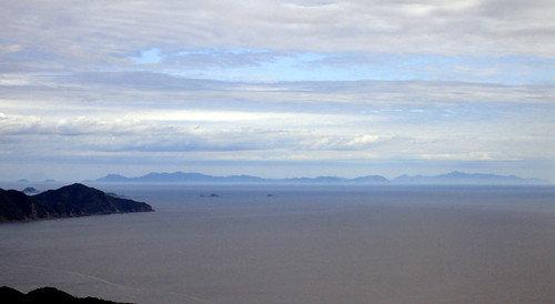
Before descending all the way down again, the road climbs high enough to offer good views of the Kawabe valley and the surrounding mountains, including the majestic Nokeeboshi-dake (left background).
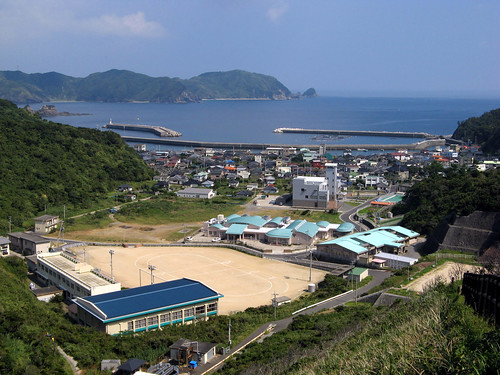
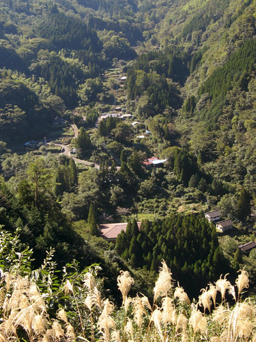 As we continue descending, a view of the village of Kureko, squeezed picturesquely into a narrow valley, seems to evoke some distant past. Most of the tiny settlements in this area do have a long history, many say that after a crushing defeat at the battle of Dannoura in 1185, as the erstwhile powerful Heike clan scattered to the country’s most remote areas in a last-ditch effort to avoid persecution and execution, some of its members found their way here. At that time, the mountains were utterly trackless, and it must have taken months if not years to reach these remote valleys, where finally, respite could be had – for a time. Then again, nearly every remote place in Japan we have visited claims to have some Heike connection or another. A perhaps less romantic possibility is that the authorities populated the area with prisoners captured in past invasions of Korea (eg. in the year 1592), the land being thought generally unfit for habitation by the natives themselves. That would tend to explain the somewhat strange sounding local place names (for Japan anyway), Kureko being one of them. When we do reach the village itself, we see signs proclaiming its historical status, but otherwise nothing out of the ordinary: just a normal tourist trap and cheap wooden and/or sheet metal houses that seem to typify country living everywhere in Japan.
We locate the trailhead with ease and stash the bikes. Our bodies require some refueling after all that climbing, so we devour some energy bars before tackling a steep ridge that will rise 700m above the valley before it begins to level off. The whole mountain range must have formed by the erosion of some kind of high plateau, so the valley bottoms are steep whereas the tops tend to be gentle, with many rather indistinct peaks along the nearly horizontal high ridges. The valleys and ridges form an interlocking fractal maze, and views are not easy to get from the tree-covered, broad summits. Even when one finds a break in the trees, the surrounding mountains seem to get in the way of the view! Perhaps this is why these hills are less popular with hikers than, say, the volcanic Mt. Aso or the Kujuu Range, which stand out pimple-like and offer commanding views of large portions of Kyushu from their summits. From those vantage points the Central Mountains appear as a solid, dark wall, whose outer ramparts mostly hide the interior. In particular, Kunimi-dake, the group’s highest peak at 1739m, can’t actually be seen all that easily from any distant vantage point. But perhaps it is this feeling of mystery and greater wilderness that attracts us here instead.
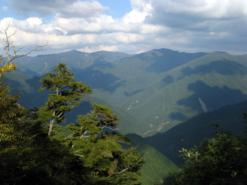
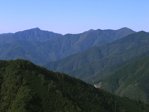
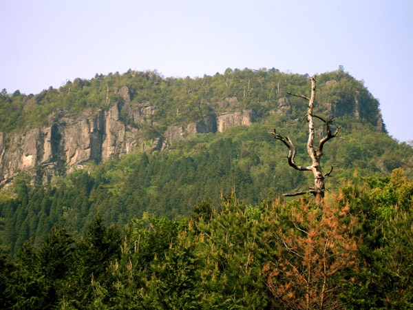
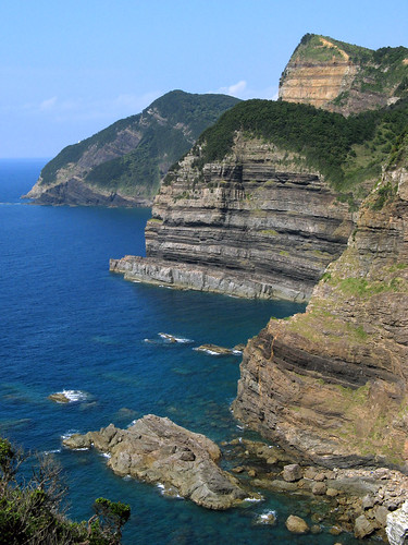
Yet another view of the rugged expanse of the Central Mountains, also known as Kyushu's Backbone Mountains. Kunimidake, the region's highest peak, can be seen in the background.
Limestone forms the bedrock of the ridge and numerous little outcrops break up the monotony of the steep climb with views of the valley below. There is even a bona-fide cave with stalactites and such. Near here we meet a solitary descending hiker who reports that the mountains are not beautiful at all today. Shocked, we inquire why, but guess the reason simultaneously with his answer: the fall colors have not arrived yet! This comment, which we would hear once again within a week, underscores the local way of thinking: it’s fall, therefore there should be colors. It’s just like, you can’t swim in the sea, because it’s September. It’s amazing to what degree this way of thinking is ubiquitous in Japan. Not even hiking an entire mountain amid vivid beauty, bright sunshine, and late summer heat could open this hiker’s eyes.
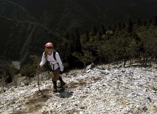
Climbing a white limestone ridge near the place where we met the sole hiker.
As we continue our climb, the valley recedes into the depths below while sounds of steady construction can be heard from several distant points on the mountainsides. Beyond the valley opposite us another new road is being constructed. It may yet take a while to complete, but this one is aiming at a pass that connects to the Kuma River, and when done, will allow escape from this dead-end valley into another equally remote drainage. That will make for an interesting bicycle route but we can’t imagine local people will ever use it much.

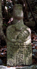
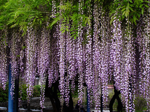
Trailside flora.
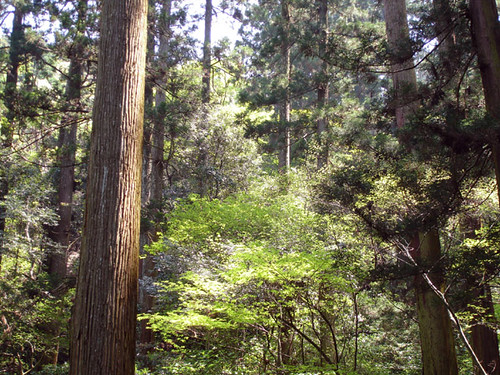
Nearing the summit, the limestone disappears, replaced by some much older metamorphic rock. Finally we enter the native forest that has been allowed to grow undisturbed along the tops of most of the high ridges in the range. The construction noises also fade away, and we are left surrounded by fairytale beauty of the virgin forest. This is the kind of magical place that inspires the landscape illustrations in the internationally popular anime movies, which perhaps give their foreign viewers the impression that Japan really looks like this. Luckily, the Central Mountains are one of the few places left where one can walk along for hours surrounded by the real version of this fairly tale.
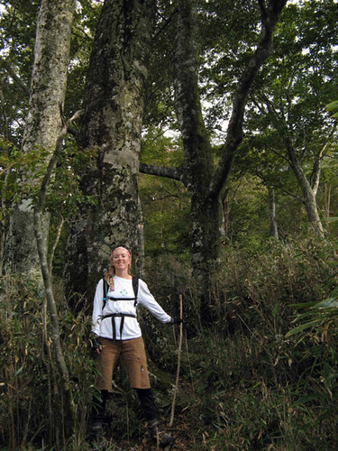
In the primeval forest.
Today’s summit is typically anticlimactic; it is hardly a bump along the flat ridge. Only small slivers of distant views can be seen through gaps in the foliage here. We continue northward along the ridge for several kilometers, gradually feeling the depths of the valleys on either side of us increasing until we stand on the end of a massive buttress, with nowhere to go but down. We thus depart the magic land of the ridge tops and drop headlong into plantations of cryptomeria trees. The trail is actually very well made and descends easily – suitable even for a mountain bike. The plantations too are unusually well kept; the trees have been thinned regularly, and healthy undergrowth has established itself. If all plantations were like this, there would certainly be fewer runoff and landslide problems around.
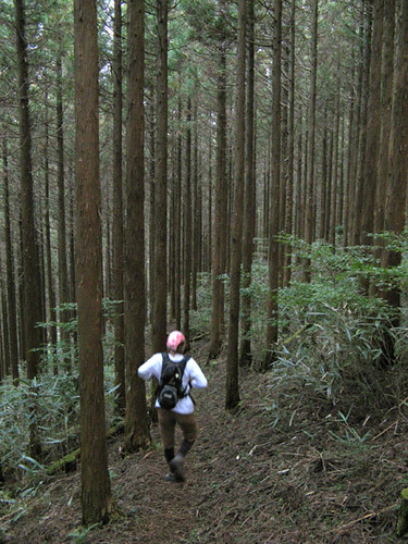
A running descent through the Cryptomeria plantation.
Night begins to fall as we recover our bikes and begin the twisty drive back out of the hills. We had certainly used the day’s daylight hours optimally. It was a fun outing and a workout for the legs, which admittedly don’t see enough exercise in the kayak.
In order to avoid the masses of slow vehicles that flood Japan’s roads as soon as it’s light out, a 4am start from Hondo was necessary. By 6:30 we began the 1000m climb that is required to enter the hills from the north. It took well in excess of another hour on very narrow, twisty, and half washed-out roads to penetrate only 14 linear kilometers into this labyrinth of steep-sided ridges and deep valleys, and reach what would be the exit point of our hike. Here we assembled our bikes and down the hill we went.
A simulated aerial view shows our bike/hike excursion around and over Kamifukune-yama, in the Central Kyushu Mountains. Our biking track is the thick red line (23.5km long, 1100m climbing), hiking is thick green (8.2km, 1060m). Black lines are other roads (thick=paved, thin=dirt), and thin green lines are other hiking trails.
The village of Shiibaru, where we soon found ourselves, clings to the slope in an unlikely part of the claustrophobically deep and narrow Kawabe River. Here we were presented with an interesting option: rather than following the valleys, we could discard common sense and reach our trailhead via a new road that instead climbed pointlessly into the mountain, only to drop precipitously again after contouring across several ridges. At its starting point, a sign announced with an air of carefree happiness: “A road connecting mountains and villages” without caring to specify further. Luckily we knew the road could take us where we wanted to go. But just beyond was a less joyful notice: closed to all traffic due to typhoon damage. Oh well, we can probably get through, we thought, and began huffing up the hill, full of morning energy.
This road stands as a good example of the utter nonsense that is modern Japanese infrastructure construction. To start with, why spend a millions of dollars to build a road that in 10.8km of length, climbs 460m into the mountain, only to go back down again, when a much straighter, 6.4km option that climbs only 150m already exists? This to connect two villages of perhaps 100 inhabitants each? Futhermore, because of the constant threat of landslides on the steep mountain slopes, the road is certain to be damaged almost every year. The answer to this riddle lies well hidden somewhere within the country's convoluted politics; suffice it to say that ultra-conservatism and corruption play a major role. It is perhaps not an accident that it's happening primarily in remote regions out of reach of the average citizen's eye. The same citizens pays for it dearly along with Japan's environment: daily, practically irreparable, and completely unnecessary damage.
Impossible roads
As we tackle the steep climb, we are presented with a view of a road similar to ours, contouring impossibly above on the opposite slope of the valley (indeed nearly every visible mountain seems to already have one). Numerous landslides have started from the road scar – tears of the mountain weeping. The slides threaten the valley below, but no worries, the engineers will probably compensate with some monstrous (though finally ineffective) concrete barrier somewhere lower down. Cresting the summit of our road, we begin to descend headlong toward Kureko Valley. Soon we find the cause of the road closure: a massive landslide, likely due to the road cut itself, has completely wiped out a section; this is now being replaced by a kind of bridge on concrete supports. We say hello to the workers who graciously let us pass – but we need to shoulder our bikes and walk a high, narrow beam. Exciting.
Before descending all the way down again, the road climbs high enough to offer good views of the Kawabe valley and the surrounding mountains, including the majestic Nokeeboshi-dake (left background).
As we continue descending, a view of the village of Kureko, squeezed picturesquely into a narrow valley, seems to evoke some distant past. Most of the tiny settlements in this area do have a long history, many say that after a crushing defeat at the battle of Dannoura in 1185, as the erstwhile powerful Heike clan scattered to the country’s most remote areas in a last-ditch effort to avoid persecution and execution, some of its members found their way here. At that time, the mountains were utterly trackless, and it must have taken months if not years to reach these remote valleys, where finally, respite could be had – for a time. Then again, nearly every remote place in Japan we have visited claims to have some Heike connection or another. A perhaps less romantic possibility is that the authorities populated the area with prisoners captured in past invasions of Korea (eg. in the year 1592), the land being thought generally unfit for habitation by the natives themselves. That would tend to explain the somewhat strange sounding local place names (for Japan anyway), Kureko being one of them. When we do reach the village itself, we see signs proclaiming its historical status, but otherwise nothing out of the ordinary: just a normal tourist trap and cheap wooden and/or sheet metal houses that seem to typify country living everywhere in Japan.We locate the trailhead with ease and stash the bikes. Our bodies require some refueling after all that climbing, so we devour some energy bars before tackling a steep ridge that will rise 700m above the valley before it begins to level off. The whole mountain range must have formed by the erosion of some kind of high plateau, so the valley bottoms are steep whereas the tops tend to be gentle, with many rather indistinct peaks along the nearly horizontal high ridges. The valleys and ridges form an interlocking fractal maze, and views are not easy to get from the tree-covered, broad summits. Even when one finds a break in the trees, the surrounding mountains seem to get in the way of the view! Perhaps this is why these hills are less popular with hikers than, say, the volcanic Mt. Aso or the Kujuu Range, which stand out pimple-like and offer commanding views of large portions of Kyushu from their summits. From those vantage points the Central Mountains appear as a solid, dark wall, whose outer ramparts mostly hide the interior. In particular, Kunimi-dake, the group’s highest peak at 1739m, can’t actually be seen all that easily from any distant vantage point. But perhaps it is this feeling of mystery and greater wilderness that attracts us here instead.
Yet another view of the rugged expanse of the Central Mountains, also known as Kyushu's Backbone Mountains. Kunimidake, the region's highest peak, can be seen in the background.
Limestone forms the bedrock of the ridge and numerous little outcrops break up the monotony of the steep climb with views of the valley below. There is even a bona-fide cave with stalactites and such. Near here we meet a solitary descending hiker who reports that the mountains are not beautiful at all today. Shocked, we inquire why, but guess the reason simultaneously with his answer: the fall colors have not arrived yet! This comment, which we would hear once again within a week, underscores the local way of thinking: it’s fall, therefore there should be colors. It’s just like, you can’t swim in the sea, because it’s September. It’s amazing to what degree this way of thinking is ubiquitous in Japan. Not even hiking an entire mountain amid vivid beauty, bright sunshine, and late summer heat could open this hiker’s eyes.
Climbing a white limestone ridge near the place where we met the sole hiker.
As we continue our climb, the valley recedes into the depths below while sounds of steady construction can be heard from several distant points on the mountainsides. Beyond the valley opposite us another new road is being constructed. It may yet take a while to complete, but this one is aiming at a pass that connects to the Kuma River, and when done, will allow escape from this dead-end valley into another equally remote drainage. That will make for an interesting bicycle route but we can’t imagine local people will ever use it much.
Trailside flora.
Nearing the summit, the limestone disappears, replaced by some much older metamorphic rock. Finally we enter the native forest that has been allowed to grow undisturbed along the tops of most of the high ridges in the range. The construction noises also fade away, and we are left surrounded by fairytale beauty of the virgin forest. This is the kind of magical place that inspires the landscape illustrations in the internationally popular anime movies, which perhaps give their foreign viewers the impression that Japan really looks like this. Luckily, the Central Mountains are one of the few places left where one can walk along for hours surrounded by the real version of this fairly tale.
In the primeval forest.
Today’s summit is typically anticlimactic; it is hardly a bump along the flat ridge. Only small slivers of distant views can be seen through gaps in the foliage here. We continue northward along the ridge for several kilometers, gradually feeling the depths of the valleys on either side of us increasing until we stand on the end of a massive buttress, with nowhere to go but down. We thus depart the magic land of the ridge tops and drop headlong into plantations of cryptomeria trees. The trail is actually very well made and descends easily – suitable even for a mountain bike. The plantations too are unusually well kept; the trees have been thinned regularly, and healthy undergrowth has established itself. If all plantations were like this, there would certainly be fewer runoff and landslide problems around.
A running descent through the Cryptomeria plantation.
Night begins to fall as we recover our bikes and begin the twisty drive back out of the hills. We had certainly used the day’s daylight hours optimally. It was a fun outing and a workout for the legs, which admittedly don’t see enough exercise in the kayak.
Labels: hiking ハイキング
posted by Leanne and Rik Brezina at
11:07 pm
|
0 comments
![]()


