Nomo
Last weekend we made we dusted off our trusty touring kayaks and made an enjoyable foray to the Nagasaki Peninsula. A little over 20km across the sea from Amakusa, this rather long and narrow finger of mountainous land extends 23km southwestward from Nagasaki City, projecting conspicuously into the East China Sea – one of many odd features along the contorted west coast of Kyushu. The sea’s moderating influence creates a sub-tropical microclimate here. Exposure to stormy seas results in extensive coastal erosion, and interesting scenery. The detrimental effects of the city nearby are brought in check in this dead end that has little flat land and nothing special to offer in the way of economic resources. These factors conspire to create a small treasure to be sought out by any casual explorer.
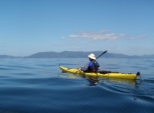
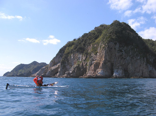
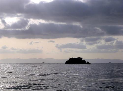
On the approach, with the mountainous backbone of the Nagasaki Peninsula on the horizon. 天草富岡から出て長崎半島へのアプローチ途中。
先週末久しぶりツーリング用カヤックを出して、天草から長崎半島に渡った。この細長い山だらけの半島は、長崎市街から南西方向へおよそ23キロ延び、東シナ海に一際突き出ている。半島の先端は気温の寒暖は海に押さえられ、亜熱帯植物なども多い。海岸は嵐の波にかなり侵食されているから、綺麗な景色に成っている。長崎市は近いけど、ここは行き止まりの陸の端だし、しかも平地や資源なども特別に何もないから、人工のての影響も比較的に少ない。つまり、自然の探検に適した場所だ。
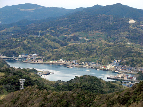
The small town of Nomo is located on a curious landlocked bay near the tip of the peninsula. Though close to Nagasaki City, quiet rural life prevails here, with fishing and orange farming as the basis of the local economy. 半島の先端に近く、ちょっと不思議な陸封の湾の周りに位置している野母町。長崎市街に近いけど、かなり田舎の風景で、地域の経済の基盤は漁業やみかん作りだろう。
While much of the coast of the peninsula, as well as many of the small islands scattered in its vicinity are worth seeing, the best parts are located on the peninsula’s extremity. (See also our entry from a previous visit.) Here lie Cape Nomo, the actual end of the mainland, and Kaba-shima, a bridged-over island which, when viewed from Amakusa, appears to be a part of the mainland. The coasts here are rocky and untamed, with caves, rock gardens, and outlying pinnacles. Human interference is at a minimum, at least when viewed from the water. Additionally, both the cape and island feature great sites for beach camping, while walking trails lead into the interior through luscious sub-tropical jungle to hilltops with spectacular views. On Kaba-shima one can walk up from the coast to the lighthouse whose powerful beam can be seen at night from all points along Amakusa’s west coast and beyond. On the cape, one can walk to the summit of Mt. Gongen from where a commanding view can be had of the islands and coasts around Nagasaki, including Hashima (Gunkan-jima or ‘Battleship Island’). On clear days even the Gotou Islands can be seen in the far distance. It’s not difficult to spend a relaxing couple of relaxing days in this quiet, natural area.
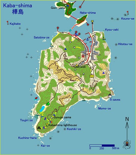
Various sources of information, including Japanese GIS, aerial photos, and of course our own surveying were compiled into this and the following maps, showing information not available anywhere else. The images are too small to fit a legend, so we hope they are fairly self-explanatory. The white squares are shrines – these always make for an interesting climb up a hill with a view. In the sea, the + signs are sunken rocks, while * are above water at least some of the time. 自分の調査と国土地理院のGISデータ及び航空写真を使ってこの二つの地図を作った。別の地図で手に入れない情報も入っている。スペースはないから記号が入れてないけど、できるだけ分かりやすくした。白い四角は神社です(神社への登りはいつも面白い散歩になる。)海の中の「+」は沈み瀬で、「*」は出る岩。
長崎半島の海岸及びその近海に散在している島々の大部分は景色が綺麗だけど、今回は半島の先端にある「野母崎」と「樺島」だけを紹介する。樺島は、半島から橋が架けている。半島は近いから、天草から見ると半島の先端になっているように見える。島も半島も岩・洞窟・崖・ロックガーデンなど面白い場所はたくさんある。 人工の物はおかげで少ない。それで、プライベートビーチでのキャンピングができる場所は数箇所ある。海岸から樺島灯台や野母崎の権現山展望台などまで、亜熱帯ジャングルを通る小道を歩くことができる。灯台のほうは小さい博物館もある。権現山展望台は、長崎港の付近の島々(軍艦島)を含む、それで空気が綺麗な時、遠く五島列島までも見える。探検者はこの辺で二日間ぐらいの楽しいくてのんびりの時間が過ごせる。
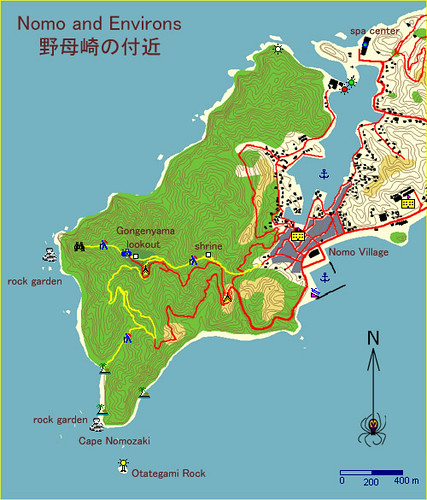
Map of Nomozaki and Nomo village. The outer coasts of this cape contain some particularly excellent rock gardens but caution is needed in rough seas due to the presence of a dozen or more boomers in the most unlikely locations. The Otategami Rock with its lighthouse is the crowning jewel of this scenic coast. As for the the interior, the shortcut trails to Gongen-yama may be a bit overgrown. However, the lowest trail, the trail from Nomo, and the roads are all easy and scenic walks. 野母崎の裏の海岸は、数箇所の素晴らしいロックガーデンがある。しかし荒れた海の時いきなりのブーマーも多いから注意がいる。灯台のある大立神岩は、この海岸の代表だ。内陸の歩道は、岬から権現山への近道はちょっと藪がうるさいかもしれないけど、道路への歩道も野も町からの歩道もいずれも歩きやすくて景色が綺麗。
The traverse from Amakusa can take three to five hours depending on conditions. From Cape Shikizaki to Kabashima it is 21km of open water, although in clear weather land can be seen in all directions except the southwest; other parts of the Nagasaki Peninsula are even a little closer at 18km to the north. However, a brisk north wind can blow up choppy waves in no time, while swell can enter from the south, and there are also significant currents to deal with, due to the presence of Ariake Sound to the east. So, this crossing is not to be underestimated. In fact, the nearby landmasses make the winds and conditions that much more unpredictable.In particular, the shallows in the vicinity of Shikizaki Cape tend to concentrate currents and swells; there are also numerous boomer rocks, so in sketchy weather give this area wide berth. Finally, note that the traverse nearly parallels a busy shipping route and care must be exercised to avoid near misses with freighters. The turning points of this corridor are well fixed by dangers, so the ships tend to stay pretty well dead-on, and in good visibility you will have nearly an hour of warning. Just remember to check your 6-oclock periodically!

A map showing our traverses between Amakusa and Nagasaki Peninsula in purple, measured tidal currents in various colors, and shipping routes in brown. The currents are marked as lines parallel to the flow of water, in the direction from the measured location (small black dot). The color codes the phase of the tide; a key can be found in the upper right corner. Some perusal will show the currents set north-easterly at flood tide and southwesterly at ebb tide, generally rotating counterclockwise during the cycle. Current speeds tend to be up to about 2km/h at spring tides, in the open. Land both in the east and west greatly perturbs the flow, making currents stronger (5km/h) and aligning them parallel to the coasts, with localized clapotis possible off the capes in bad weather. But with a little planning, the currents can be used to the paddler's advantage. 私たちの天草と長崎の横断の軌跡はこの地図で紫線で、フェリーや貨物船の航路は茶いるで、計った潮流は色んな色で表す。潮流は、計った地点(黒い点)から流れの方向へ向けている。その色は、潮汐の位相に合わせている(右上の図参照:「HW」は満潮、「Ebb」は下げ潮、「LW」は干潮、「Flood」は上げ潮)。ちょっと見ると、上げ潮の流れは北東へ、下げ潮は南西になるで、一般的に方向は左回りの回転だ。流速は大潮の時、陸から離れた場所で2kmに近い。陸の付近、両側で流れに強い影響があり、流速はかなり増えていて、波があれば激潮の可能性がある。しかし、横断時間を丁寧に潮に合わせると、流れを有利に使える。
天草から樺島への横断は、天気や海の状態次第3-5時間かかる。四季咲岬から樺島まで21キロの外海があるのに、空気の透明な日南西側以外の水平線 に陸が見える。実は四季咲岬の北側長崎半島の海岸は一番近くて18キロの距離がある。しかしどの方向でもこれはそんなに簡単な横断ではない。周りの陸の影響で風が不規則で、方向や風力が変わりやすい。特に北風が吹きだすとアっと言う間に波が発生する。南西側からうねりも入りやすい。それで、東にある有明海の影響で普段より強い潮流もある。図では、私達の二回の横断の軌跡が載せていて、その時の流れの状態も表してある。四季咲岬の付近の浅瀬による流れと波もが集中しているから、荒れた天気この辺を大きく避けたほうがよい。それで、横断線は交通量の多い航路を悪い角度で交差しているので貨物船にもずっと注意がいる。航路はいずれもの曲がり目で危険によってはっきり決まっているから、船舶は普段に航路をずれないので、しかもよい見通しの時船舶が近づくまえ一時間近く見えるから、避けるのは問題ない。ただ、たまに後ろを見ろ事に注意。
About to arrive at the eastern tip of Kabashima, Leanne is distracted by a flock of curious boobies circling overhead. 樺島に到着ところ、理杏は頭上に旋回しているカツオドリを見て騒然とする。
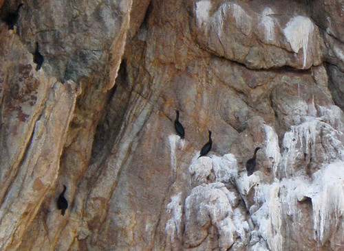
Cormorants find purchase on the ceiling of a sea cave in Kabashima. 樺島の海岸の洞窟の天井に止まっているウミウ。
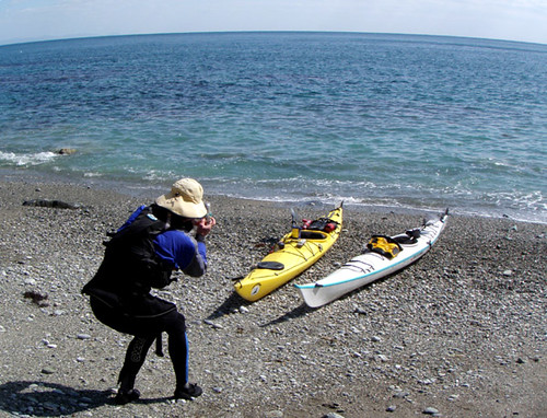
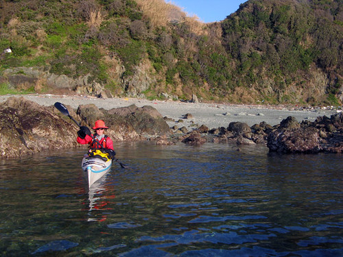
Landing at a convenient beach after the traverse, Rick takes a picture of our trusty touring craft. 樺島の到着ポイントにて。

Contorted metamorphic rocks at Kuchi-no-hana, Kabashima. 歪んだ変成岩の岩層、口の鼻にて。

Leanne strolls a splendid path to the Kabashima Lighthouse. 樺島灯台への素晴らしい遊歩道。
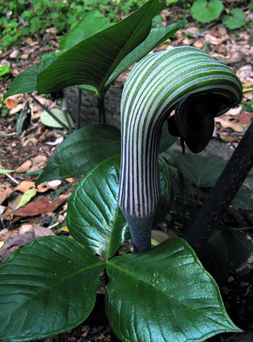
早春の花:マムシ草とケマン草。
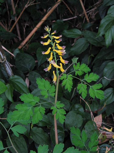
Spring wildflowers: Arum and Fumaria.
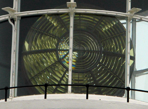
The enormous lens of the Kabashima Lighthouse. 樺島灯台の巨大なレンズ。
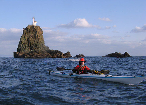
Leanne by the Otategami Rock, just off Cape Nomo. 野母崎に近くの大立神岩。
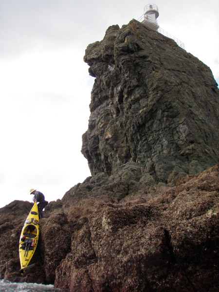
Climbing to the lighthouse is a delight, but landing on the Otategami Rock is not easy, even in reasonably calm conditions. 灯台まで登りたいけど、大立神岩にあがるのは難しい。
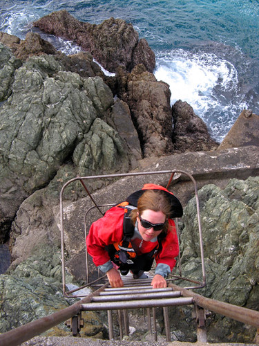
The rest is easy. A stainless steel ladder climbs the 20-m vertical cliff to the flat top of the rock. ステンレスのハシゴがあるから、登り自体は簡単。20メートル程の垂直の岩壁だ。
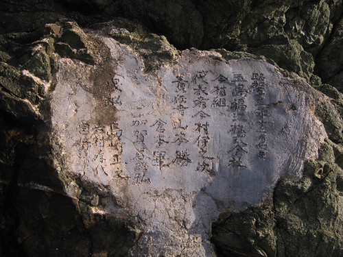
An impromptu but durable inscription tells us the lighthouse was built in 1950 by a company based, interestingly enough, in the Gotou Islands. 適当けど、耐久だろう。大立神岩にての銘文。灯台は59年前、なんて五島での会社に建たれた
Land’s end – Beautiful Cape Nomo seen from Otategami. 大立神灯台から見た陸の端の景色の美しい野母崎。
Exploring the rock gardens off Cape Nomo. 野母崎のロックガーデンを探検する。
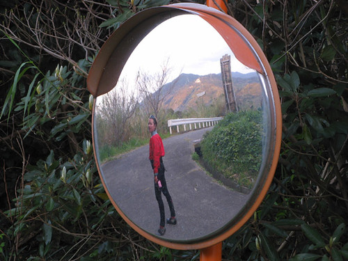
Leanne is reflected in an old curve mirror as we walk the road to Gongen-yama. 権現山への散歩途中、理杏はカーブミラーに映った。
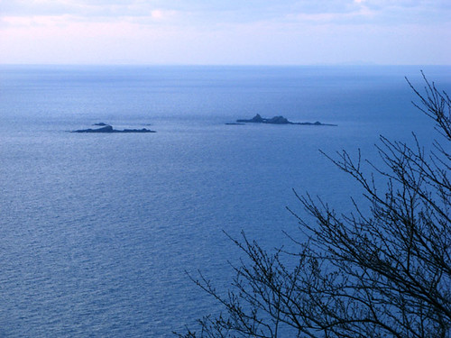
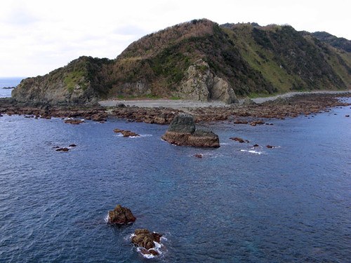
Mitsuse Rocks, seen from Gongenyama lookout. On the distant horizon, Hira-shima and Eno-shima, visited by us on the way back from Gotou last summer, can just barely be made out. 権現山展望台から望んだ三ッ瀬。遠くの水平線に、分かりにくいけど、去年の夏五島からの途中で訪れた平島と江島が薄く見える。
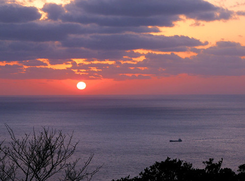
The grandeur of the East China Sea at sunset dwarfs a freighter rounding Cape Nomo. こんな広い日の入りの東シナ海の海原に、貨物船も小さくに見える。
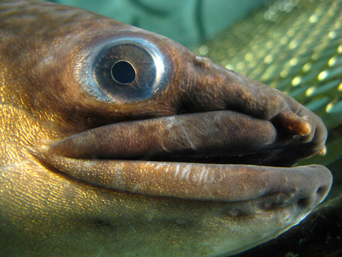
Kabashima’s claim to tourism fame is a rather nice and well-taken-care-of tank displaying two rare giant tropical eels. These were found living in the village well, and are further evidence of the area’s warm microclimate. 樺島の観光地の大うなぎの水槽。熱帯の種類の大うなぎは、日本では珍しいものそうだ。集落の井戸で発見されてから、その井戸のすぐ隣なんとなく綺麗な水槽で飼われている。
Amakusa seen in the distance across the sea as we contemplate the traverse back. 天草への帰り前、樺島から遠く見たその山だらけの西海岸。

Leanne sails the silvery sea back to Amakusa on this last weekend of calendar winter. Soon the quality of light will change as our world becomes saturated with color, humidity, and heat.理杏はセールを出して、天草へ水銀のような海を渡る。この冬っぽい光も今から消えていって、色・湿度・暑さの飽和した風景になる。

On the approach, with the mountainous backbone of the Nagasaki Peninsula on the horizon. 天草富岡から出て長崎半島へのアプローチ途中。
先週末久しぶりツーリング用カヤックを出して、天草から長崎半島に渡った。この細長い山だらけの半島は、長崎市街から南西方向へおよそ23キロ延び、東シナ海に一際突き出ている。半島の先端は気温の寒暖は海に押さえられ、亜熱帯植物なども多い。海岸は嵐の波にかなり侵食されているから、綺麗な景色に成っている。長崎市は近いけど、ここは行き止まりの陸の端だし、しかも平地や資源なども特別に何もないから、人工のての影響も比較的に少ない。つまり、自然の探検に適した場所だ。
The small town of Nomo is located on a curious landlocked bay near the tip of the peninsula. Though close to Nagasaki City, quiet rural life prevails here, with fishing and orange farming as the basis of the local economy. 半島の先端に近く、ちょっと不思議な陸封の湾の周りに位置している野母町。長崎市街に近いけど、かなり田舎の風景で、地域の経済の基盤は漁業やみかん作りだろう。
While much of the coast of the peninsula, as well as many of the small islands scattered in its vicinity are worth seeing, the best parts are located on the peninsula’s extremity. (See also our entry from a previous visit.) Here lie Cape Nomo, the actual end of the mainland, and Kaba-shima, a bridged-over island which, when viewed from Amakusa, appears to be a part of the mainland. The coasts here are rocky and untamed, with caves, rock gardens, and outlying pinnacles. Human interference is at a minimum, at least when viewed from the water. Additionally, both the cape and island feature great sites for beach camping, while walking trails lead into the interior through luscious sub-tropical jungle to hilltops with spectacular views. On Kaba-shima one can walk up from the coast to the lighthouse whose powerful beam can be seen at night from all points along Amakusa’s west coast and beyond. On the cape, one can walk to the summit of Mt. Gongen from where a commanding view can be had of the islands and coasts around Nagasaki, including Hashima (Gunkan-jima or ‘Battleship Island’). On clear days even the Gotou Islands can be seen in the far distance. It’s not difficult to spend a relaxing couple of relaxing days in this quiet, natural area.
Various sources of information, including Japanese GIS, aerial photos, and of course our own surveying were compiled into this and the following maps, showing information not available anywhere else. The images are too small to fit a legend, so we hope they are fairly self-explanatory. The white squares are shrines – these always make for an interesting climb up a hill with a view. In the sea, the + signs are sunken rocks, while * are above water at least some of the time. 自分の調査と国土地理院のGISデータ及び航空写真を使ってこの二つの地図を作った。別の地図で手に入れない情報も入っている。スペースはないから記号が入れてないけど、できるだけ分かりやすくした。白い四角は神社です(神社への登りはいつも面白い散歩になる。)海の中の「+」は沈み瀬で、「*」は出る岩。
長崎半島の海岸及びその近海に散在している島々の大部分は景色が綺麗だけど、今回は半島の先端にある「野母崎」と「樺島」だけを紹介する。樺島は、半島から橋が架けている。半島は近いから、天草から見ると半島の先端になっているように見える。島も半島も岩・洞窟・崖・ロックガーデンなど面白い場所はたくさんある。 人工の物はおかげで少ない。それで、プライベートビーチでのキャンピングができる場所は数箇所ある。海岸から樺島灯台や野母崎の権現山展望台などまで、亜熱帯ジャングルを通る小道を歩くことができる。灯台のほうは小さい博物館もある。権現山展望台は、長崎港の付近の島々(軍艦島)を含む、それで空気が綺麗な時、遠く五島列島までも見える。探検者はこの辺で二日間ぐらいの楽しいくてのんびりの時間が過ごせる。
Map of Nomozaki and Nomo village. The outer coasts of this cape contain some particularly excellent rock gardens but caution is needed in rough seas due to the presence of a dozen or more boomers in the most unlikely locations. The Otategami Rock with its lighthouse is the crowning jewel of this scenic coast. As for the the interior, the shortcut trails to Gongen-yama may be a bit overgrown. However, the lowest trail, the trail from Nomo, and the roads are all easy and scenic walks. 野母崎の裏の海岸は、数箇所の素晴らしいロックガーデンがある。しかし荒れた海の時いきなりのブーマーも多いから注意がいる。灯台のある大立神岩は、この海岸の代表だ。内陸の歩道は、岬から権現山への近道はちょっと藪がうるさいかもしれないけど、道路への歩道も野も町からの歩道もいずれも歩きやすくて景色が綺麗。
The traverse from Amakusa can take three to five hours depending on conditions. From Cape Shikizaki to Kabashima it is 21km of open water, although in clear weather land can be seen in all directions except the southwest; other parts of the Nagasaki Peninsula are even a little closer at 18km to the north. However, a brisk north wind can blow up choppy waves in no time, while swell can enter from the south, and there are also significant currents to deal with, due to the presence of Ariake Sound to the east. So, this crossing is not to be underestimated. In fact, the nearby landmasses make the winds and conditions that much more unpredictable.In particular, the shallows in the vicinity of Shikizaki Cape tend to concentrate currents and swells; there are also numerous boomer rocks, so in sketchy weather give this area wide berth. Finally, note that the traverse nearly parallels a busy shipping route and care must be exercised to avoid near misses with freighters. The turning points of this corridor are well fixed by dangers, so the ships tend to stay pretty well dead-on, and in good visibility you will have nearly an hour of warning. Just remember to check your 6-oclock periodically!
A map showing our traverses between Amakusa and Nagasaki Peninsula in purple, measured tidal currents in various colors, and shipping routes in brown. The currents are marked as lines parallel to the flow of water, in the direction from the measured location (small black dot). The color codes the phase of the tide; a key can be found in the upper right corner. Some perusal will show the currents set north-easterly at flood tide and southwesterly at ebb tide, generally rotating counterclockwise during the cycle. Current speeds tend to be up to about 2km/h at spring tides, in the open. Land both in the east and west greatly perturbs the flow, making currents stronger (5km/h) and aligning them parallel to the coasts, with localized clapotis possible off the capes in bad weather. But with a little planning, the currents can be used to the paddler's advantage. 私たちの天草と長崎の横断の軌跡はこの地図で紫線で、フェリーや貨物船の航路は茶いるで、計った潮流は色んな色で表す。潮流は、計った地点(黒い点)から流れの方向へ向けている。その色は、潮汐の位相に合わせている(右上の図参照:「HW」は満潮、「Ebb」は下げ潮、「LW」は干潮、「Flood」は上げ潮)。ちょっと見ると、上げ潮の流れは北東へ、下げ潮は南西になるで、一般的に方向は左回りの回転だ。流速は大潮の時、陸から離れた場所で2kmに近い。陸の付近、両側で流れに強い影響があり、流速はかなり増えていて、波があれば激潮の可能性がある。しかし、横断時間を丁寧に潮に合わせると、流れを有利に使える。
天草から樺島への横断は、天気や海の状態次第3-5時間かかる。四季咲岬から樺島まで21キロの外海があるのに、空気の透明な日南西側以外の水平線 に陸が見える。実は四季咲岬の北側長崎半島の海岸は一番近くて18キロの距離がある。しかしどの方向でもこれはそんなに簡単な横断ではない。周りの陸の影響で風が不規則で、方向や風力が変わりやすい。特に北風が吹きだすとアっと言う間に波が発生する。南西側からうねりも入りやすい。それで、東にある有明海の影響で普段より強い潮流もある。図では、私達の二回の横断の軌跡が載せていて、その時の流れの状態も表してある。四季咲岬の付近の浅瀬による流れと波もが集中しているから、荒れた天気この辺を大きく避けたほうがよい。それで、横断線は交通量の多い航路を悪い角度で交差しているので貨物船にもずっと注意がいる。航路はいずれもの曲がり目で危険によってはっきり決まっているから、船舶は普段に航路をずれないので、しかもよい見通しの時船舶が近づくまえ一時間近く見えるから、避けるのは問題ない。ただ、たまに後ろを見ろ事に注意。
About to arrive at the eastern tip of Kabashima, Leanne is distracted by a flock of curious boobies circling overhead. 樺島に到着ところ、理杏は頭上に旋回しているカツオドリを見て騒然とする。
Cormorants find purchase on the ceiling of a sea cave in Kabashima. 樺島の海岸の洞窟の天井に止まっているウミウ。
Landing at a convenient beach after the traverse, Rick takes a picture of our trusty touring craft. 樺島の到着ポイントにて。
Contorted metamorphic rocks at Kuchi-no-hana, Kabashima. 歪んだ変成岩の岩層、口の鼻にて。
Leanne strolls a splendid path to the Kabashima Lighthouse. 樺島灯台への素晴らしい遊歩道。
早春の花:マムシ草とケマン草。
Spring wildflowers: Arum and Fumaria.
The enormous lens of the Kabashima Lighthouse. 樺島灯台の巨大なレンズ。
Leanne by the Otategami Rock, just off Cape Nomo. 野母崎に近くの大立神岩。
Climbing to the lighthouse is a delight, but landing on the Otategami Rock is not easy, even in reasonably calm conditions. 灯台まで登りたいけど、大立神岩にあがるのは難しい。
The rest is easy. A stainless steel ladder climbs the 20-m vertical cliff to the flat top of the rock. ステンレスのハシゴがあるから、登り自体は簡単。20メートル程の垂直の岩壁だ。
An impromptu but durable inscription tells us the lighthouse was built in 1950 by a company based, interestingly enough, in the Gotou Islands. 適当けど、耐久だろう。大立神岩にての銘文。灯台は59年前、なんて五島での会社に建たれた
Land’s end – Beautiful Cape Nomo seen from Otategami. 大立神灯台から見た陸の端の景色の美しい野母崎。
Exploring the rock gardens off Cape Nomo. 野母崎のロックガーデンを探検する。
Leanne is reflected in an old curve mirror as we walk the road to Gongen-yama. 権現山への散歩途中、理杏はカーブミラーに映った。
Mitsuse Rocks, seen from Gongenyama lookout. On the distant horizon, Hira-shima and Eno-shima, visited by us on the way back from Gotou last summer, can just barely be made out. 権現山展望台から望んだ三ッ瀬。遠くの水平線に、分かりにくいけど、去年の夏五島からの途中で訪れた平島と江島が薄く見える。
The grandeur of the East China Sea at sunset dwarfs a freighter rounding Cape Nomo. こんな広い日の入りの東シナ海の海原に、貨物船も小さくに見える。
Kabashima’s claim to tourism fame is a rather nice and well-taken-care-of tank displaying two rare giant tropical eels. These were found living in the village well, and are further evidence of the area’s warm microclimate. 樺島の観光地の大うなぎの水槽。熱帯の種類の大うなぎは、日本では珍しいものそうだ。集落の井戸で発見されてから、その井戸のすぐ隣なんとなく綺麗な水槽で飼われている。
Amakusa seen in the distance across the sea as we contemplate the traverse back. 天草への帰り前、樺島から遠く見たその山だらけの西海岸。
Leanne sails the silvery sea back to Amakusa on this last weekend of calendar winter. Soon the quality of light will change as our world becomes saturated with color, humidity, and heat.理杏はセールを出して、天草へ水銀のような海を渡る。この冬っぽい光も今から消えていって、色・湿度・暑さの飽和した風景になる。
Labels: kayak expedition シーカヤック遠征
posted by Leanne and Rik Brezina at
12:00 pm
|
2 comments
![]()


