Bike distance total: 167km
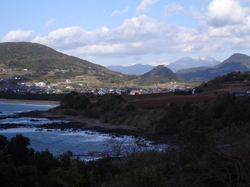
Kunimi Sanchi is a small mountainous area with several rolling mountains nearly 1000m high in southwest Kyushu between the small cities of Minamata and Hitoyoshi in Kumamoto Prefecture, and Ooguchi in Kagoshima Prefecture. Because there are other, higher peaks in the vicinity, the Kunimi Mountains are not particularly well-known. Kunimi means, in Japanese, ‘country-see’ and in Kyushu there must be two dozen mountains by this name, two of which are found here, more or less side-by-side, while one more exists about 30km further east, adding to the confusion. The highest summit of the group, at 998m, curiously does not carry a name. The group’s most accessible peak, Oozeki-san at 915m, is the westernmost and therefore closest to civilization; for this reason it has road access and a forest of antennas on top, though its shape is so rounded and gradual that when seen from Amakusa, its profile blends into the general mountainous background of the Kyushu mainland. Nevertheless the area is scenic and many unpaved forest roads criss-cross the hills and the passes in between them; these make the Kunimi Sanchi a suitable destination for a weekend trip.
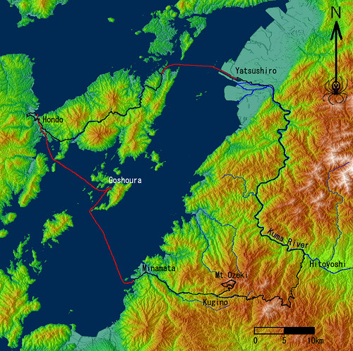
Getting there from Amakusa is fairly convenient because a ferry plies the waters of the Yatsushiro Sea between Hondo and Minamata several times a day, making an additional stop at Goshonoura, Amakusa’s largest unbridged island. The ferry boat is old and slow so the crossing takes more than 2 hours (and is not cheap), but the passage through the narrow Hondo Strait between Shimo and Kami islands and the inland sea scenery make the ride interesting and worthwhile.
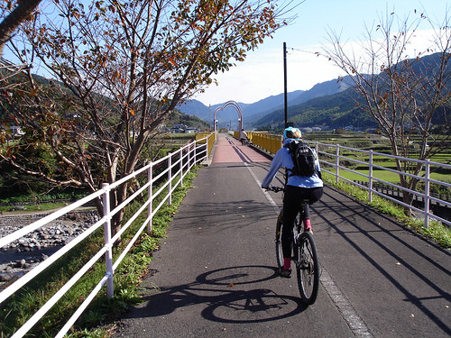
Arriving in Minamata, one has the option of visiting the Minamata Disease Museum which documents the world’s most infamous case of massive mercury poisonings caused by indiscriminate dumping of industrial waste into the sea. We had lunch at MOS Burger (‘Fine Japanese Hamburgers’); hopefully my mustard chicken burger was not contaminated! Then we set out eastward, soon encountering a pleasant rails-to-trails type path auspiciously named ‘Japan’s longest exercise park’. It is a national obsession for every place to claim it has something superlative, and the results are often humorous. There are likely many bike paths in the country longer than this one’s 13.08km, though if it hadn’t occurred to anyone else to think of a trail as a long exercise park, this one might just be Japan’s longest one.
In any case, the trail was very pleasant and its gentle gradient was easy on the legs. Pretty autumn scenery drifted by on either side, the drained paddies very green with new leaves sprouting tenaciously from the roots left in the ground after the rice harvest. One feels almost grateful for the Japan Railways’ shortsighted ambition of building tracks everywhere; not many people must have ever ridden this train between two obscure towns hidden in the rural mountains. The railroad came complete with a climbing loop and a series of tunnels to break through the Kunimi hills, but these, alas, seem to be off limits for the casual bikestrian.
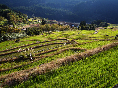
At the end of the trail we arrived at the village of Kugino where, at a visitor center called ‘Airinkan’ (Love Forest Hall) a Mr. Sawahata gave us useful information about the most interesting MTB route up Mt. Oozeki. This road, he said pointing at a detailed map, is mostly unpaved and its lower section passes by some scenic stepped rice fields; views of the surrounding hills can be had from its upper meanders. Such local information is always good to have, though it is not easy to come by; unlike Mr. Sawahata most locals are rarely familiar enough with their environs to be of much help. We had planned our route with good topographical maps, yet such details as road surfacing and frequency of maintenance can seldom be read there.
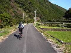
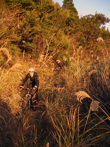
We modified our plan slightly to take in this recommended road, and began climbing the remaining 600 vertical meters. On the way, we passed Samukawa spring, gushing delicious clear water in spite of the season’s dryness. Where the gentler slopes near the summit were bare of trees, tall ‘susuki’ grass had grown thickly, encroaching upon the road.
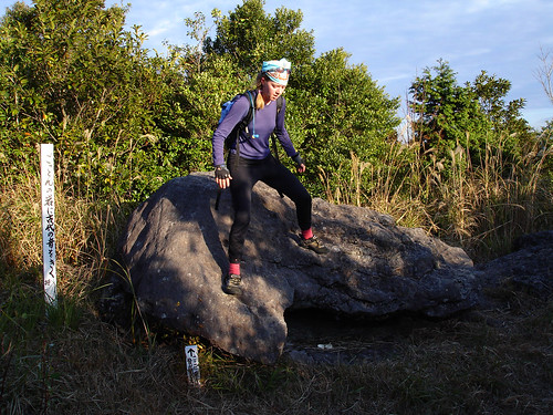
Within sight of the summit antennas we happened upon ‘Gotton-iwa’ (Rumbling Rock); when rocked, it did indeed rumble. It is said the sound recalls a battle that took place here many centuries ago.
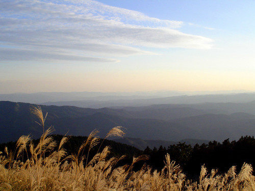
On the wide flat summit of Mt. Oozeki, from among the microwave antennas and over the tall grass, a wide panorama of rolling hills in Kyushu’s southern Satsuma province (today Kagoshima Prefecture) spread beneath us. This area is known for its impenetrable dialect and its history of insurgency against the Imperial Rule; as the southwestern extremity of Japan for many centuries, it had been difficult to control. Today, besides the dialect, Kagoshima seems much the same as anywhere else; perhaps its sovereign undercurrents have finally been quenched by the flood of technology and modern convenience: a final victory for the forces of imperialism.
Choosing a different route to descend Mt. Oozeki, we found it not maintained and thoroughly overgrown with susuki. After several kilometers of pushing through this, we cut our losses and traversed back onto our ascent route. Though we seldom have to retrace our track during trips, several more hours fighting this straw forest just to end up a few kilometers up the valley road did not seem worth it. We descended the good road rapidly back to Kugino, ate a dinner of instant Ramen, sardines and Ritz crackers at the general store, and resumed our easterly course up the valley, now shrouded in darkness. Under a cold starry sky chilled air had already begun streaming down from the mountain slopes. In the next village we spotted what turned out to be an abandoned school on a hilltop lit by a lonely street lamp. In the sandy schoolyard we set up camp and spent a quiet night.
Greeted by a frosty dawn, we mounted our bikes with legs stiff from the night’s cold. Frozen feet and fingers came back to life painfully as we energetically pedaled up and out of the valley.
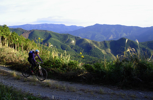
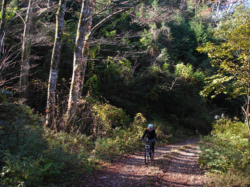
Crossing into Kagoshima Prefecture, we entered an extensive and labyrinthine network of forest roads, all unpaved and very enjoyable to ride.
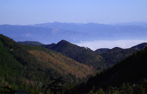
For several hours our path wound and twisted along the upper ridges of the Kunimi Mountains. Here and there a view was afforded us of the deep, geologically curious Hitoyoshi valley, flat and extensive but surrounded on all sides by tall mountains. Even as the sun slowly began to warm the mountainsides and 1302m tall Mt. Nokeeboshi stood out sharply on the far side, dense chilly fog lay in the valley below. Fittingly, when five farming towns and villages in the valley amalgamated in 2003, they adopted as their new name Asagiri, or Morning Fog.
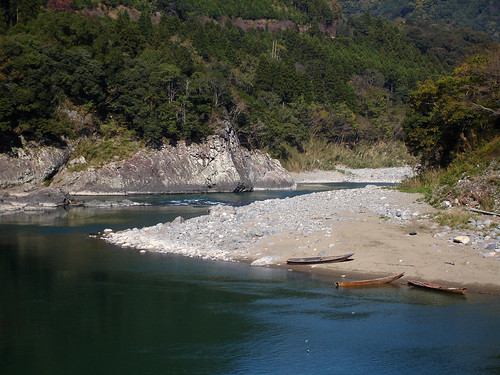
By mid-morning we completed the traverse and began descending toward Hitoyoshi. In no time at all we dropped 700 vertical meters to the Kuma River, which, breaking through the mountain barrier in a 40km long, steep-sided canyon, drains the valley into the Yatsushiro Sea. Miraculously spared of major damming (a couple of smaller dams exist), the river sports a series of moderate rapids that make it quite popular with rafters.
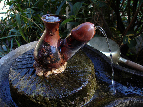
In an inauspicious place along the riverside we happened on a fertility shrine which might perhaps offend western sensibilities. A couple dozen phallic symbols of various sizes and styles from totem pole to this delightful drinking fountain, graced the tiny shrine and its surroundings. Though in most respects the Japanese seem more reserved than, say, North Americans, this shyness does not seem to always apply when it comes to the various basic bodily functions. Or is it that we Westerners seem to be particularly retentive about this topic?
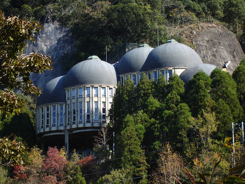
Perhaps a little more bizarre was this building clinging to the side of the canyon. It is, of all things, a museum dedicated to the inventor Thomas A. Edison, hence the vague resemblance of the domed roofs to light bulbs. Here in the middle of rural Kyushu, it is actually not all that unusual. One might be surprised to know that Japan has in excess of 3,500 museums – surely a world record! Many of these are located in rural areas (almost every self-respecting town has one) and dedicate themselves to similarly eclectic themes. It is hard to believe that such institutions actually turn a profit; they stand as yet another type of monument to the country’s wanton waste of public funds on pointless construction. That aside, from an esthetic point of view, this building is certainly weird enough to be noticed.
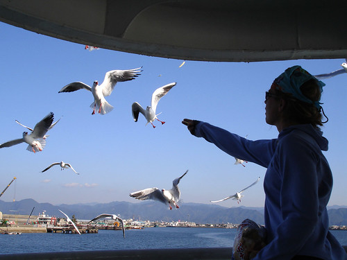
The Kuma River suddenly breaks out of the mountains near the industrial city of Yatsushiro and spreads out immediately into a delta on the coastal plain before spilling into the shallow Yatsushiro Sea. A 40 minute ride on a ferry takes one across to Matsushima on the eastern tip of Amakusa’s Kami island. A flock of seagulls that invariably follows the ferry is a bit of an attraction and small bags of potato chips specifically to feed the birds are for sale on board. We watched the birds’ flying feats as the mountains we descended from receded into the hazy background. We still had Kami-shima to cross: 35km and one mountain pass to go. There is a hot spring on the way to relax our tired muscles. The trip had been fun and we came away with intimate knowledge of yet another little corner of this amazingly varied landscape that is Kyushu.