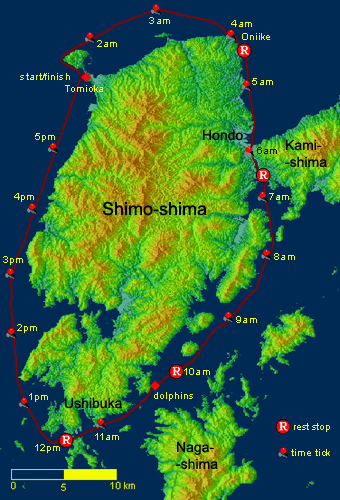
Distance: 115 km
Time: 16 hours
Average Speed: 7.2 km
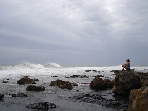
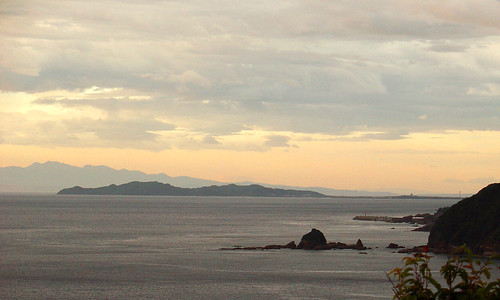
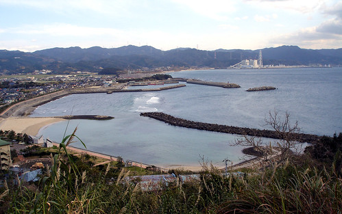 Tomioka. Extensive concreting of the fishing port, artificial beach, and coal-burning power plant has ruined the natural appeal of this part of the coast, but the sea here is relatively clean.
 Conditions on July 9 seemed favorable for a 1-day circumnavigation of our home island. A large tide during the day would accelerate progress southward through the Nagashima Strait, and an incoming typhoon would hopefully provide rideable wind and waves for the northward return leg along the island’s west coast. Loaded in my kayak was ample food and fluid: 8 160-calorie gel packs, 5 Snickers bars, a boiled egg, a pre-packaged lunch of yakisoba noodles, 3 liters of electrolyte replacement drink, 2 liters of Coca-Cola (all of this was actually consumed). Additionally, I carried ample floatation and wetsuit (in case things got rough, but not needed as it turned out), a pocket AM radio to relieve boredom, and a spare paddle. Driving hastily over the mountain to Tomioka, I make a 1AM start from the fishing port.
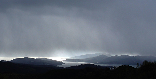
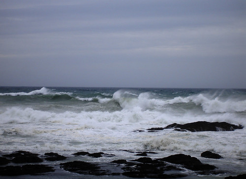
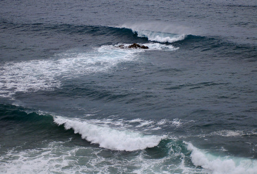 Typhoon waves impinging upon the Tomioka coast (this picture was taken after completion of circuit). Though not of great height, the waves’ long, straight crests and even 10 second spacing leaves no doubt of the existence of a storm in the offing.
The night is eerily quiet, calm and tepid, as it always is the day before a typhoon. A fat gibbous moon hangs in the western sky, and the summer stars are shining steadily overhead. The sea looks like a flexible mirror, its surface smooth and bending with the first swell of the as yet distant storm. Here and there in the shallow water off the Tomioka peninsula, ghostlike waves rise suddenly, pushed up by the close seafloor. I steer well clear of the rocks scattered off this shore, where the waves are breaking noisily. No ships ply the water at this hour and once clear of land and the breakers, the only sound is the splashing of the bow and paddle blades as they cut the water. Luminescent algae mark my wake, while other patches, presumably responding to pressure waves, light up faintly and psychedelically under the surface each time I lean on the paddle. Unusually clear air and scattered layers of high clouds, though portending the storm, make for a beautiful night to be on out on the open water, alone. Manmade lights on the distant horizon blend with those of the stars, providing navigational clues: the sky a great compass, the horizon a circular map. One by one I pick out the lighthouses against the background of the coastal towns: Sezume-zaki, Gotsuu-sho, Yu-shima, Kogame-iwa, Nanatsuu-iwa, No-se. How familiar I have become with this little corner of the world!
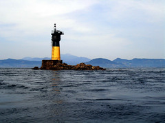 The Gotsuu light during the day.
The moon sets directly behind me, and the sky darkens. The Milky Way, directly overhead, is nearly indistinguishable from the wispy clouds. A panicked fish, suddenly awakened by the quiet approach of the kayak, leaps in the wrong direction, hits the foredeck with a loud thud, bounces off my arm, and splashes back into the water. I, on the other hand, am fully awake and alert, but how long this state will last concerns me. A couple months ago, on a 2-day version of this trip with Leanne, I became terribly demoralized during the middle of the second day with about 30km to go. We stopped on a beach, went for a swim and brewed up some instant Ramen, which snapped me back into action. The efficacious Ramen was the main reason for packing the noodle lunch today. I also decided to steer a straighter course this time, away from land, conducive to a meditative state which will hopefully make it easier to pass time. Somewhere I had read that certain Tibetan ascetics run many nights and days at a time, covering hundreds of kilometers over mountain, valley and desert without stopping. At night they focus on a single star ahead of them, reaching a trance that allows a blissful separation from their miserable bodies. Taking their heed, I put myself in alignment of the Gotsuu and Sezume lights and staring at these, paddle vigorously for an hour until I see the dark silhouette of the lighthouse emerge directly in front of me. Paddling such a rigid, straight line makes me ultra-aware of even a light cross current and through the subtle changes in heading required to keep on course I too succeed in reaching an energy-conserving trance.
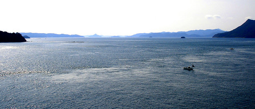
Beyond the lighthouse I gratefully reach the inflow of the tidal current through Hayasaki Strait. Midsummer night tides are always weak, yet with continues energetic paddling I am soon cruising at over 10km/h. The morning star rises, and before too long traces of dawn appear. I approach land at Oniike, to cut the northeast corner of the island. A single streetlight at the port, blinding to my dark-accustomed eyes, illuminates a few people on the pier fishing for squid. With the change of direction comes a change of mood, and I turn on the AM radio. NHK has live coverage of the Germany-Portugal world-cup soccer game, which keeps me adequately amused. The sun rises, and a few fishing boats radiate out over the smooth water from Saitsu port. Because of the typhoon warning, there will be few boats out today, even though it’s still dead calm. This is the way it always is here: people believe the authorities more than nature herself. The news comes on; the typhoon features prominently because it is crossing the vicinity of Okinawa. A long list of warnings indicates impending pandemonium in Kyushu as well. As if to confirm my earlier hunch, a Tokyo announcer on a call-in show is shocked, then embarrassed, when a caller from Kyushu reports sunny skies. You mean, it’s not raining? Evidently he had not bothered to consult the list of current weather conditions. Anyway, the end of the rainy season has not even been officially declared!
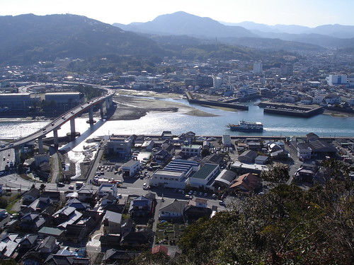 The Minamata ferry begins its passage through the narrow, river-like Hondo Strait. The Seto Bridge links the city of Hondo on Shimo Island (background) to Kami Island and, by means of five more bridges, to the Kyushu mainland.
 The hours slip by. Portugal gets beat up by the Germans; the typhoon slips out into the East China Sea, heading west of Korea and as far as the Japanese news is concerned, into a black hole. One by one the warnings for Kyushu are retracted. Having slipped through the narrow Hondo strait, I finally exit onto the Yatsushiro Sea, where finally a south breeze can be felt. Stirred up by the breeze and reflected by concrete seawalls that rim the curve of the shore, choppy waves gather around me from all directions. No big deal really, but I should mention it because this will be the roughest piece of water along the whole trip.
 Winter rainsqualls drape the narrow passage between Shimo and Kami islands; beyond, the Yatsushiro Sea reflects brilliant white sunlight.
More time goes by. Picking up the ebb current, I am flushed swiftly southwest, making a brief stop at the tiny Shimomate Island in the middle of the Nagashima Strait. During past smallpox epidemics, this and other such islets were used to dump (in Japanese literally throw out) the sick people. As the story goes, their miserable moaning could be heard all the way back on the shore, about a mile away. A few gravestones still litter the tiny island, while the sea flows around it, like a huge river.
 Looking south down the Nagashima Strait. The rippling sea surface tells of powerful currents flowing. These are fastest in the island-choked narrows in the distance, where they sometimes reach 15km/h. With the help of the current, it is possible to reach the narrows by kayak from here in only 1 hour.
It’s a beautiful day. The sky is free from its usual summer haze, a fresh wind is blowing; this and the currents kick up dancing blue waves. Suddenly, there is a different kind of splashing: I look and see a dozen or so dolphins jumping; playfully yet swiftly moving through the water, straight toward me. How beautiful, graceful and efficient they are in the water! They swim right up to my kayak, perhaps not noticing it until the last instant, slow down for a few seconds to inspect this rare craft. And off they go again, jumping and playing in the waves. They swim right up to the shore, then turn and pass by me one more time before picking up speed and disappearing into the waves beyond my bow. It is said that these dolphins split from the main group in Hayasaki Strait where they were constantly tailed by tourist boats (this is in fact Amakusa’s foremost tourist attraction). Certainly they seem much happier here, where they are left alone.
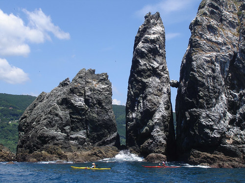
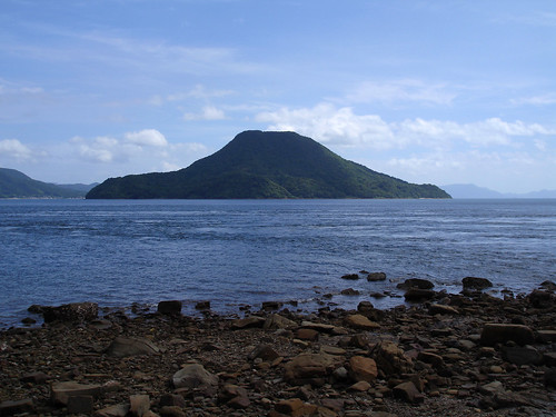 Ubu Island also known as the Amakusa Fuji, seen from Shimomate. The sea currens swirl swiftly around both islands. A small pod of solitude-seeking dolphins has found a home here.
I make my last shore break in Ushibuka, near the island’s southern tip, take a cooling swim and devour the noodles. 40km remains, and an earlier peek at the calm, open sea, as well as the benign breeze mean that I will have to paddle this, rather than be blown and pushed, as I had half-expected. Oh well, at least I don’t feel tired or sore. I exit the port and steer through the extensive and treacherous shoals in this area. I had prepared a careful route through these in case of big waves, but it’s unnecessary; it’s calm enough for a seat-of-the-pants approach.
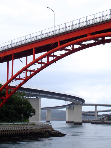 Do we have enough bridges? The narrow straight between Shimo and Gezu islands in Ushibuka marks the southernmost point of the circuit.
Once out of the shoals, there’s not much to do but paddle on. I engage in a new trance-inducing activity: clocking off each passed kilometer. 8 minutes, that’s 7.5 km/h, a pretty good pace; I wonder if it can keep it up the whole rest of the way. Cape Oniki, the island’s west extremity, glides by, then the bizarre, isolated rocks of Kogase and Oogase. Normally on Sundays all three of these are jam-packed with sport fishermen; today, not a single one. Too bad: the day before a big storm is the best time to fish! Though no one will admit it, Nature has played a big trick on everyone today. These sport fishermen are $40 a pop to the local skiff captains. A festival in the coastal village of Shimoda has also been cancelled, and hundreds of tourists won’t be buying overpriced octopus shish kabobs.
 Looking south at a portion of the steep and relatively wild west coast of the Shimo Island, with Cape Oniki seen beyond Youkaku Bay in the middle distance. On the horizon, the Koshiki group in Kagoshima Prefecture can just be made out, more than 50km distant.
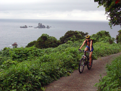 Oogase rocks seen during a MTB exploration of the coast.
From Oogase, I can clearly see my goal, exactly 20km distant, though the hilly peninsula with its low isthmus looks like a separate island. I’m keeping my pace, and even exceeding it; there must be a slight back current. To take maximum advantage of wind and swell, I stay about a kilometer offshore, but it probably makes no difference.
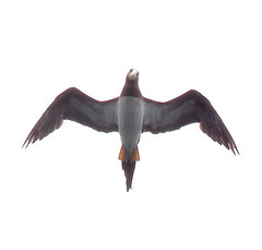
A loose flock of boobies seems to find my boat a great amusement: repeatedly they circle downwind, make a dipping, fast turn with a wingtip grazing the water, gain some height and shave off speed, then glide in straight to me like a plane on final approach to a carrier landing. A few meters directly above me, each bird takes its turn skillfully hovering and staring down. Then it breaks off to do the same maneuver again, and again and again… For hours they don’t get tired of this game. I too am somewhat amused by their antics and funny faces. I notice that each bird has its own orbit routine, which never varies.
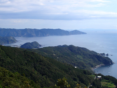
 Looking north along the west coast of Shimoshima. The Tomioka peninsula with its natural land bridge is prominent. In the left distance is the silhouette of the old volcanic massif of Nodake in Nagasaki Prefecture.
10km short of destination the natural land bridge connecting the peninsula with the main island emerges from beneath the sea horizon. Though the sky is now nearly overcast with the leading edge of the typhoon cloud, the air is still quite clear and the long Nomo Peninsula, Mt. Nodake, and Mt. Unzen’s graceful silhouettes stand spread out in a wide arc in front of me. Not at all tired, I increase my pace to 8km/h for the home stretch. More than my muscles, my joints and tendons ache a bit, and I take care varying hand position and straightening my fingers periodically lest they cramp arthritically around the paddle shaft. Thus in good style I reach the port lighthouse and soon after stumble out of the kayak onto the boat ramp, exactly 17 hours after departing. That’s 16 hours paddling, 1 hour total in breaks. If I get better organized, I can cut break time more…though my legs are so stiff that I can barely walk!
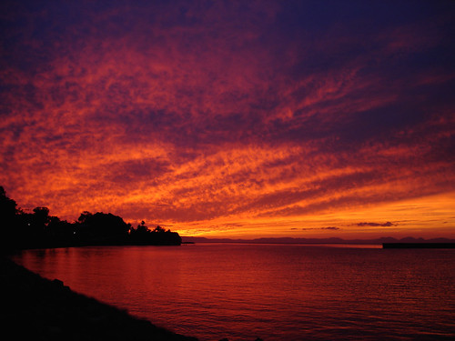
It’s a glorious evening after a bright summer day. The typhoon swell coming in now is perceptibly bigger than last night, though nowhere near the 3m that was forecast. The wind too, is only about 10 knots instead of 15 to 20. Before returning home, I check out the nearby KDD Beach, a favorite surfing spot. In hopes of typhoon swell, surfers had come from far and wide, and a Navy Seal army of wet-suited bodies is bobbing on the waves; every now and then one is big enough for one or two to get up and take a short ride. Oh well, nature is basically unpredictable: that’s part of the fun. On my way home, the hitherto gray sky suddenly explodes into color as sunlight from below the horizon illuminates the cloudbank from below. For a magical 5 minutes a shifting, aurora-like display plays out before my eyes, then quickly recedes westward and fades away.
 Storm waves break on the shallows off Cape Shikizaki, Shimo Islands’s northwestern extremity.
Next day, the influence of the typhoon peaks out as it passes about 600km to the west of Amakusa. We take a leisurely drive along the west coast to enjoy the scenery. Although 5 meter waves were forecast, this never came to be for some reason; with some caution we could have even gone kayaking. As is always the case after a typhoon, it’s very hot in spite of the strong wind.