Gumbies

Monday, June 26, 2006

Thanks

Our trip to Goto is long over, but still I would like to thank and rethank all the people who showed us so much kindness during our trip.
First of all Kenji Suemitsu, a kayak guide in Amakusa, who supplied us with current up to date weather forecasts throughout our trip. Without this valuable information we could never have proceeded with confidence.
Also, thanks to Meiji Taniguchi who let us park our car at his workshop in Nagasaki. What a great friend!
During our trip so many people were kind to us including the ferry workpeople, the local fisherpeople, the shop owners and kids. During these trips, it's the people we meet that really make the experience. The people living on these out of the way island are very patient, curious and kind. I especially have a soft spot for the darling old grandmother types who brought us freshly made miso soup and various treats.
Thanks also to Kazumi Matsushita and her mother for the mini oranges for our trip. They were refreshing and delicious.
This was a wonderful trip, I recommend it to kayakers and cyclist. If anyone wants copies of any of our maps, please feel free to contact us.

Golden Gotou Part 6 of 6

north
This map was constructed using Kashmir 3D software combined with our GPS track recorded on our trip.
To see the full map, click here
After a night in Hamanoura, where efforts to make an artificial beach in a windswept bay only created dunes in the local schoolyard and across the highway, leaving the sea as muddy as it was before, we set out north along the east coast of the curiously shaped Nakadoori Island. A terrific south wind is blowing, and we slide across the water at 8km/h merely holding the paddle at shoulder level. Occasionally a gust of wind picks whirls of seawater into the air; these come behind with a warning roar and we duck down while they pass over. Hugging the shore we feel safe but the mouth of one small bay needs to be crossed; we manage this safely and grab a break on the opposite shore. The wind almost blows us over sitting on the boulders and it seems incredible that progress on the sea is possible in these conditions. An announcement that all the ferries to Nagasaki have been canceled drifts to us on the wind from a nearby village PA system. We get into the boats again and once on the water, again things don’t seem so bad.
stained glass chuuchi
In another hour, we get as far as we safely can, to a tiny fishing port that is the last outpost of civilization on this side of the island. We stash the boats and go for a walk still in our wetsuits through sheets of torrential rain driven horizontally by the wind. We take temporary refuge at the oversize Chuuchi church (is that name a coincidence?) that has large stained glass windows commissioned all the way from Italy. ‘Christ walking on the Sea’ seems of relevance today; another one, bearing the caption ‘Jesus talks with the fishermen’ features some remarkably Japanese-looking folks juxtaposed with Christ in the background. We walk to the local store where we eat Cup Ramen and talk with the friendly storeowner, who confirms that the people in the stained glass windows are indeed her neighbors. When the bread delivery lady offers us a ride to the hot spring about 10km away we do not refuse, and wait out the rest of the storm soaking in hot water. No one else is in the baths, so we also take the opportunity to scrub down our stinking rubber suits with soap and hot water. Exiting the baths, we discover that place even has free Internet! Riding the bus back in the late afternoon we chat up the driver (we are the only passengers) who then takes us on a scenic drive, stopping the bus and pointing out all the interesting sites on the way: a steep cliff here, dogs tucked into a stone wall there…in the end, he waives our fare as he drops us off. The rain is just ending, the day’s light is fading, and the storm is over. Great timing!
defunked jidouhanbaiki
Cape Tsuwa is the northern end of Nakadoori Island, the tip of a freakishly long and narrow peninsula. Civilization peters out into the sea here, and as we walk a trail through dense vegetation, we see that the last house has long been abandoned, and the nearby jidouhanbaiki has long been out of commission.
kashiragashima
It’s a long day and we make only a few stops to see more churches: the one at Kasiraga-shima is unique because it is made of stone.
red bridge
Going under this crimson red bridge Rik spots an unusual sight- a land snake swimming across the straight.
snake
church_fukumi
The wind begins blowing again, the waves build, and the current turns against us; by the time we arrive at the brick church in Hukumi, exhaustion is upon us; we were so busy dealing with the waves that we didn’t think to eat or drink anything. When we land we can barely haul the boats out of the water at the port.
night scene
But Narao town is now only a couple km away. A final half-hour paddle and we enjoy another hot spring bath and Ramen noodles in this rather curious town all crowded onto the hillsides, with labyrinthine pathways and a shrine with an enormous banyan tree with spreading branches and hanging roots. The next morning, we haul our kayaks onto a ferry; by early evening we are back in Amakusa, really only 120km distant but seemingly a world away.

Thursday, June 22, 2006

Golden Gotou Part 5 of 6

goto part 5 map
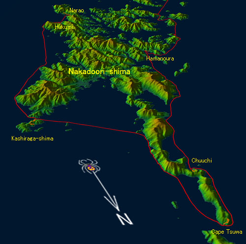
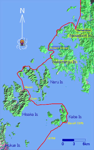
See the entire map of the Goto Islands.
jetfoil
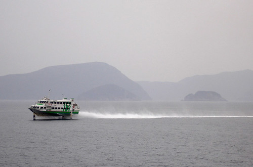
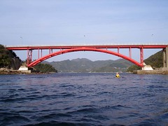
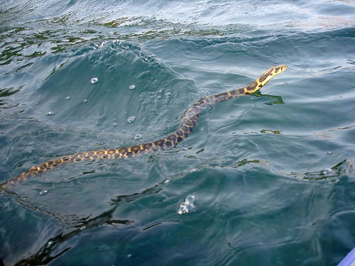
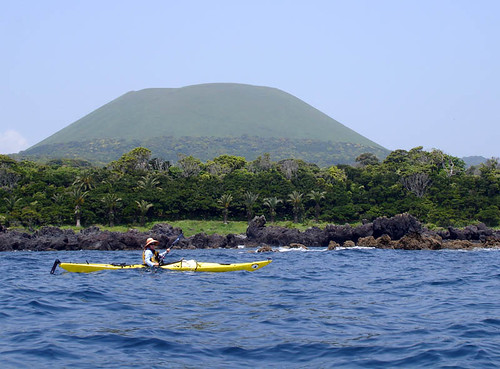
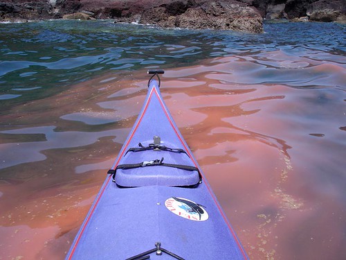
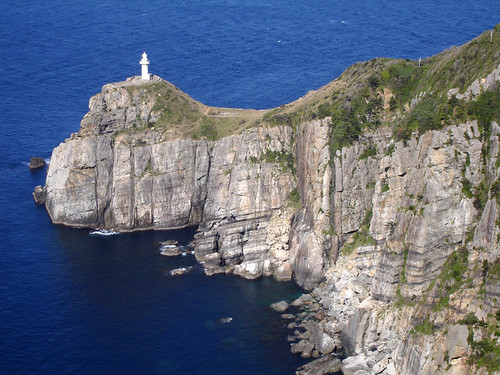
Red tide continues staining the sea as we begin a long, open crossing from the south-east corner of Hukue island over to Kaba island, where now a new danger is imminent. We are about to cross the path of the jetfoil boats that several times a day slice the water between Hukue and Nagasaki. We see a car ferry pull out of port and, timing its progress, we watch it descend slowly below the horizon. Its white smokestack disappears when it is only 10km away. The kayaker sits so close to the water that the Earth’s curvature severely limits her line of sight. Allowing also for the jetfoil’s slightly smaller size, at its cruising speed of 80km/h we will have only 5 minutes after we first spot it till it’s on top of us. At top paddling speed, we can cover about 700m during that time; thus a safe transit can be accomplished if one knows the ship’s route to this degree of accuracy. We had recorded our own ferry’s route, and now we are hoping the jetfoil will follow this path as well. Although its pilots must be looking for fishing boats in their way, kayaks are smaller and notoriously hard to see. Worse, they may be relying on their radar, which picks up the fishing boats but not kayaks. So we speculate about what to do if the brown stuff hits the fan: take off life jacket, tip the boat, then dive as deep and long as one can. If we time this right, it should be possible to dive to safety since the foils can’t be much deeper than 2 meters below the surface. Also we should separate so if one kayak gets shredded we can both limp to shore on the other. It seems scary to ponder so we get pretty nervous. 1 km from ground zero we begin our sprint across, intently scanning the relevant bits of horizon: Leanne back and left toward Hukue, I on the 2 o’clock position toward Nagasaki. And, as luck would have it, at exactly 80m short of intercept I see a white spot on the horizon, precisely in the expected direction. Too late to turn back now, so we sprint for it; a minute or two later the speck has not gotten any bigger and turns out to be only a fishing boat. But 10 minutes later, we see the jetfoil, and at about the same time can also hear the roar of its engine. Safe now, we watch him pass at a 1.3km distance, 6 minutes after first sighting it. We think how the safety margin might have been increased: fly a radar reflector, use the topography better and cross nearer land where the ship’s track may be more certain, and check the ferry schedule…though there’s no guarantee the boats will follow that, especially during the hectic tourist season.
kaba1
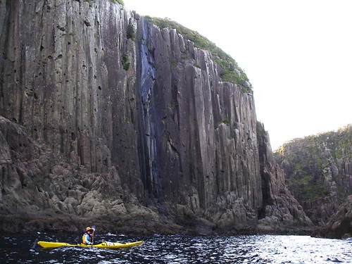
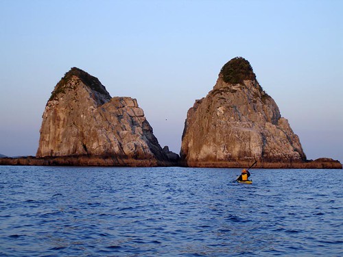
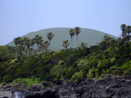
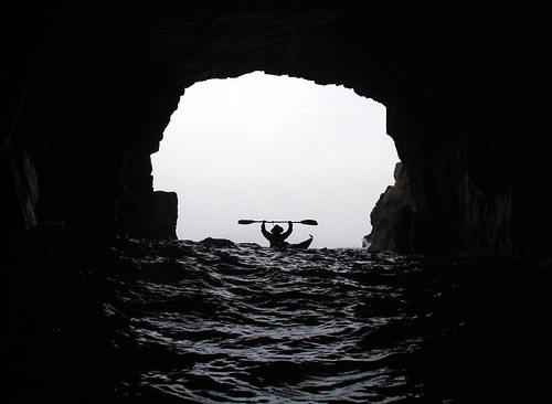
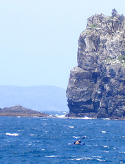
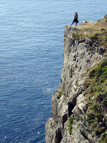
Soon after we reach the cliffy south shores of Kaba-shima, the scenery awes us with its beauty: steep columnar basalt cliffs drop directly into the sea. The detour has been well worth it. We enter some interesting caves, wary of the deafening crashing of the sea swell deeper within. This outlying, sparsely habitated island turns out to have some of the most spectacular natural scenery in Gotou, although due to its position is not visited very often. We figure the fishing on these rocky shores would be excellent, but we do not see a single fisherman. Maybe it is too expensive to take a boat taxi this far out.

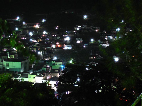
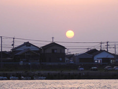
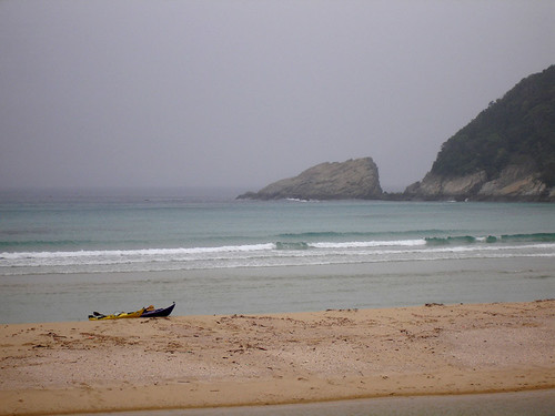
Night falls upon us as we re-cross open water back west toward the main archipelago, but the sea is calm and the only boats around have already settled into position for a night of squid fishing, having turned on their powerful lights that blind us even from a distance. Where our prows and paddles cut the water thick with red-tide plankton, it gives off a psychedelic phosphorescent glow, so bright sometimes that it lights up our faces from below in a ghostly way. As we approach Hisaka-jima we look for a place to land and camp, but in the dark this is rather difficult, as nice-looking beaches turn out to be nothing but rough boulders and gravel.
tent
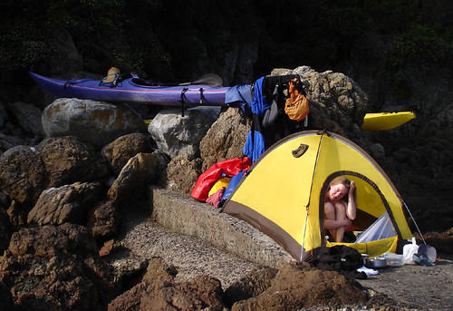
Eventually we find a narrow space on top of a derelict, stinky, abandoned concrete structure. Judging by the distribution of oyster shells the tide covers most of this, so we crowd the tent onto a section we hope won’t get flooded. While doing this, the already rising water dislodges my boat, which drifts away; a classic gumby mistake. Leanne paddles around in circles in the pitch darkness while I ride the back of her kayak scanning the water with my headlamp for the runaway boat. Fortunately we find it quickly. We lift the boats onto some rocks and exhausted, hit the sack. During the night we don’t get flooded and the morning dawns bright and clear.
gorin church
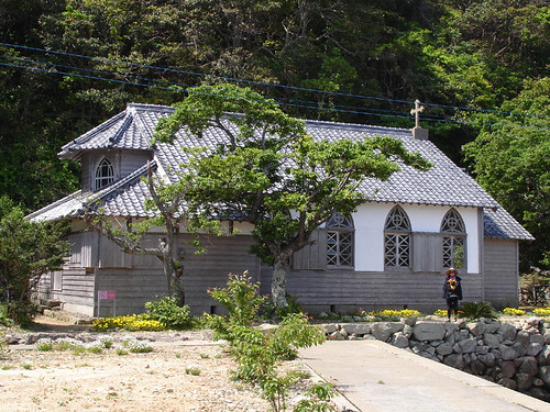
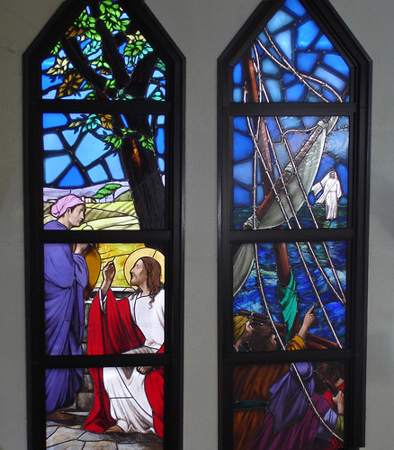
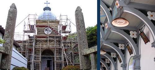
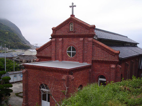
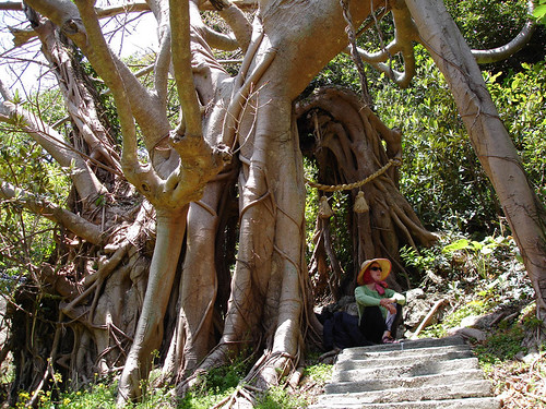
A short paddle takes us to Gorin church, certainly one of the most valuable cultural artifacts of the archipelago. Made of wood by a local carpenter more than 100 years ago, it is preserved today only through the concerted efforts of conservationists (the village, consisting of one house and no road, already has a new church).
gorin_inside of church
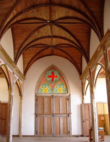
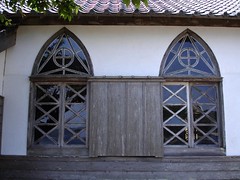
From the outside, the church evidently looks much the way an ordinary house used to look around that time, while the inside has vaulted (“bat-wing”, as the Japanese like to say) ceilings and the unmistakable feel of a Christian church.
gorin_church windows
Its beauty resides in its simple design. We are moved by this cultural treasure more deeply than by any other during this journey.

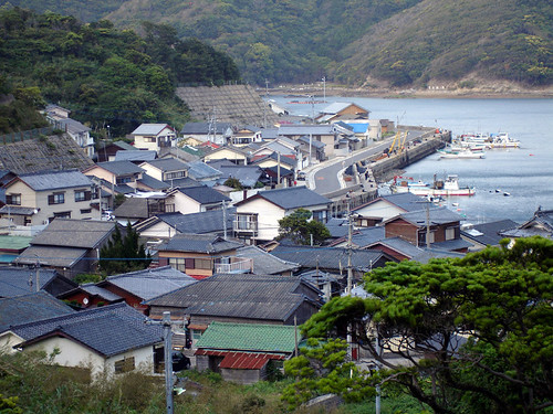
We navigate the Naru Strait and then turn north-east along the north shores of Naru and Wakamatsu islands. The north shores of Naru are wild and precipitous, but Wakamatsu with its low hills, complex shoreline, and many outlying islets is more habitable.
stone graves1
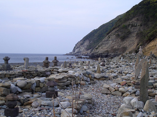
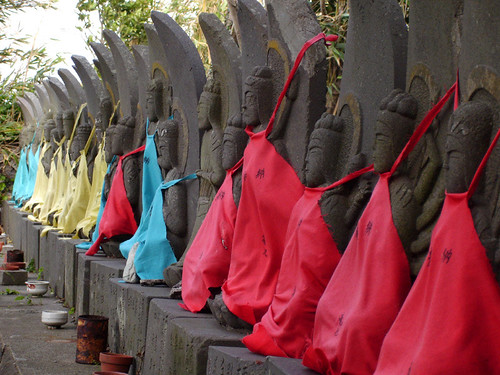
Twisting through some narrow straits between these, we find an old graveyard, evidently from the Kamakura Period, though new stones have been added as if for decoration. Though the surroundings have been built over in the standard pointless fashion (toilets, artificial beach, concrete blocking the strait that once served as an entrance into the calm inland anchorage), the place still induces a kind of spiritual feeling. Though the hour is late and camping here would be ideal, we must move on; we paddle away into the dusk and strengthening wind.

Wednesday, June 21, 2006

Shall we dance


Shall we dance, originally uploaded by vibromama.

On July 9th (Sunday), starting at 1 o'clock in the afternoon, Leanne will be performing Japanese dancing in Kami Amakusa at the Aroma Hall. If you are interested please come. It's a charity event, admission is free, but a donation is appreciated.

Thursday, June 15, 2006

Golden Gotou Part 4 of 6

In the lee of Cape Ose we can relax again and admire the majestic scenery. Now free of the erratic wind waves, the water heaves slowly with a swell from some storm far to the south. These are perhaps our favorite conditions: along the rocky coast, the sea heaving like the chest of a sleeping giant, and although the waves still meet the shore with some force, their rhythm is slow and much more predictable. With some sense of timing, one can slide quickly between rocks propelled by the rising of a swell, or be lifted several meters up near a vertical wall without much danger of being dashed against it.
twin rocks
The sun hangs low in the sky and the coast has turned northward away from us in a wide, sweeping bay. We decide to cut short and aim toward Futago-Se, literally and aptly, the Twin Rocks, which the designer of this grand landscape placed just halfway across the bay’s mouth as if to relieve the boredom of sea-traversing kayakers. Each rock towers over 50m high, and the passage between them, although deep, is less than 2m across. The rocks provide a minute or two of entertainment; then it’s on to open water again.

sunset
It is dark by the time we arrive at the fishing port of Kurose. Deceived by tourist brochures promising a beach with facilities and perhaps blinded by visions of salty potato chips and other town conveniences, we pass by a beautiful, remote beach, land just outside the dumpy town, and settle on the flat concrete of the port. A walk around the town’s very dark street turned up only a jidouhanbaiki. We drink cans of hot coffee, then pass a restless night as various cars pull in and out of the port and voices are heard fulfilling some questionable purpose. Funny about these ports; some are dead quiet at night, while others seem to be hangouts for shady characters. We were relieved when our GPS announced dawn was around the corner and it was time to get up. Once in the water, we feel again in our element. The sun rises, Japanese style, over the dense wires and cheap-looking plastic houses. This could be Hokkaido, Okinawa, or any place in the 3000km in between.

oni shore
The coast is again low, volcanic, and shelving in great shoals into the sea. The swell has grown overnight, and the shelves become surf zones many times more dangerous than the cliffs we passed yesterday. We give them wide berth but a few still surprise us on the seaward side. These shoals lay like traps, some just deep enough to trip only one wave in 100; this can give the paddler a nasty surprise.
onidake
onidake2
The long-extinct volcano of Onidake dominates the scene. It has been given a buzz-cut and is pushed aggressively as perhaps Gotou’s number one tourist destination. Its grassy dome looks almost artificial in the brown haze that hangs above the sea today.
redtide
The calm conditions and intense sunshine of the past couple of days has proved too much for the sea, and it breaks out in great splotches of red tide. A winter of absorbing untreated runoff from town and farm has increased nutrient levels, and as soon as the water warms to near 20C, algae growth goes unchecked. We’re somewhat surprised to see so much of this here, where the waves and currents of the open sea regularly wash the coasts. It would not surprise us if absolutely no facilities exist on these islands to clean waste water and farming runoff. When, the next day, we hear a tour guide explaining to the naïve tourists that the red water is actually fish eggs, we have to laugh, wondering if they made this up or are actually told to say so. In any case Leanne takes it upon herself to educate the tourists, for better or worse, what it is they are actually looking at.

Saturday, June 10, 2006

Golden Gotou Part 3 of 6

pinocchio
Stimulated with such little entertainments (see Golden Gotou Part2), several kilometers of the coast goes by, wild except for a couple of places where the ridge almost yields to connect the sea with the landlocked bay beyond; had we been in a real pinch, we could have portaged the kayaks across here and completely avoid the rough sections around the cape.

Cape Oose
oosezaki-detail
This cape lies at the south west of Fukue Island and is the most exposed area in Goto. This place is also the most popular place for fishing, and indeed when we passed by we saw more then 20 people bravely clinging to the rocks in hopes of catching “the big one”. Compared to these people we felt quite a bit safer on our kayaks.

The previous day riding on a strong north wind, we cruised down the west coast of Fukue Island, stopping only briefly at Arakawa hot spring for a mid day soak. A soak in the small simple bath helped to relieve our fatigue but did little to reduce my stress due to the looming voyage ahead. Putting on our freshly washed wetsuits we continued south toward Tamanoura Village.
scout2
Once arriving at the Tamanoura beach we went to check out the strait separating us from the final leg of the rocky west coast. Due to the current and the strong winds, the strait was full of breaking waves. We concluded that we were stuck here for the moment, at long last put on our dry clothes and ventured on to town.
akou
This town is home to a large Akou tree, which stands beside the shrine. These giant sprawling trees seem incredibly strong and sturdy, as we failed to notice any movement of the branches in this strong wind.
koinobori
The Children’s Festival in Japan in early May welcomes the birth of boys in the family. On these islands where depopulation is a big problem, the birth of a son is greeted with an incredible display of bright colored fish flags in front of the house
buddas
In the center of town we climbed up to the temple that overlooked the village. Here dozens of small Buddha statues stand somewhat neglected and frozen in time.
tamanoura
Due to the strong winds we decided that tomorrow would be a rest day, and to toast this we went for a wonderful dinner in town. We both ordered the fish special of the day, which included sashimi, various fish products, fish soup and rice. We concluded that indeed the fish from Goto tasted more delicious than any other fish we had ever eaten.
oosezaki-cliff
Much refreshed from our dinner we returned to our campsite for the night.
Early the next morning (no relaxing on our rest day!), in order to check out the condition of the sea, we hiked the 14 kms to the lighthouse on Cape Oosezaki. The view from the lighthouse was spectacular and quite terrifying. Steep gray cliffs descending straight down for 100 meters into the crashing waves below did little to alleviate my dread of the day ahead. Still, we were happy to see at the cape near the shore, the waves were moving fast but were not so large. The larger waves caused by the current going against the wind were further away from the shore. The south side of the Island was completely calm.
Upon observing the conditions we felt comfortable with the task ahead and once back at camp we decided with the change of the current in the afternoon to proceed onward around the cape. So much for our relaxing rest day!
Once through the strait we were committed to our goal, as the strong northerly wind made a retreat impossible. Also the shore was rocky and no friendly landing areas existed. For this part of the trip we decided to rope together with our towline. We expected getting out of the strait to be quite difficult. In fact it wasn’t, and the towline ended up being a hindrance rather than an asset. Going south toward the cape being blown by the wind and riding on the waves was the most intense 45 minutes of the trip. Here there was no room for error, no space for misjudgment, we were fully committed. Trying to keep my cool, I breathed deeply, almost to the point of hyperventilation. The hardest part ended up being when Rik’s kayak was pulled forward on a wave, and since we were roped together I would also get yanked ahead. This made it difficult to keep my balance. The correct thing to do would have been to release the towline-, which is fairly simple, but we didn’t have time to talk, or speculate on our options. Finally we were at the Cape wising past dozens of bewildered people fishing.

Thursday, June 08, 2006

climbing at Nodake


climbing at Nodake, originally uploaded by vibromama.

Ever since we came back from our climbing trip in Mexico during the New Year holiday, we have been psyched about climbing. On most weekends, weather permitting, we hit the closest crag (a mere 2 hour drive and $20 dollar- 30 minute ferry ride). The area is called Nodake and offers climbs at all levels. For such a small area, there are many high quality climbs. The scene at the cliff is friendly, and climbers both young and old gather from all over Kyushu. On this particular day we were posing for pictures taken by a new friend, Mr. Yugawa, an accomplished paraglider and an interesting character.


Rik on Higashi Route
Here Rik warms up on one of our favorites "The Higashi Route".

Friday, June 02, 2006

Golden Gotou Part 2 of 6

takahama
Timing is everything- The golden hour comes about 5am the next day, and after one last walk to the lighthouse to check the conditions, we launch the boats and finally round Cape Kashiwa in reasonably calm conditions. As we head south a tail wind picks up as expected, speeding our progress. Out of the drizzly mist to the southwest emerges Saganoshima, a small but very interesting volcanic island with a rocky crater half-sunk in the sea. Although we wanted to visit there, the sea won’t permit it today and we have to stick to the shore where the waves are manageable. Quicker than expected we arrive at Takahama, a rare, natural sand beach with spectacular scenery. We talk briefly to the only other person there: a solo cyclist from Tokyo who has spent a comfortable night under the roofed structure built for summer bathers. Soon we are off again, aiming at the entrance of a fjord-like passage that will offer protection from the increasingly stormy sea.

deer1
The deer episode


Finally sheltered from the howling wind we explore the coast more closely. As we are playing around in the rock gardens and caves, in one steep gully I spot hidden in the rocks an animal. Rik scoffs at me “What are you thinking there are no animals here”. On closer inspecting we find that it is indeed a deer. It must have somehow fallen down the steep slope above. As it tries unsuccessfully to climb up the cliff to get away from us we soon realize that he is trapped and can’t figure out how to get himself out. At this point Rik gets out of his boat and goes above the deer and forces him into the sea. Possibly the first time in his life, the deer is in the sea swimming for his life. At the next gully he once again tries to get out, but his attempts are again thwarted. Although a skillful climber, after numerous long falls, landing surprisingly well on his feet, he looks no closer to figuring out an easy escape from these steep walls. Things are not looking good for the poor deer. Once again, this time I get out of my boat and go above the deer and force him into the water. Rik guides the deer along into the open sea and toward a safe easy exit. During this process the deer darts into a cave, which has no exit. Rik in his attempt to steer the deer out capsizes and gets one of our headlamp and binoculars wet. Finally Rik after a quickly executed roll manages to get himself and the deer out of the cave.
The pair atlast arrives at a moderately steep slope and the deer obviously struggling, barely manages to drag its soaking wet body out of the sea and up the step hill to freedom.
Later while recounting our story to a local woman sitting by the sea repairing her nets, she comments how we should have clubbed it and ate it.
deer2
The binoculars were new and quite expensive because they were guaranteed waterproof, ideal for kayaking and recommended for rugged use. What a disappointment. Next comes the exhausting procedure involved in getting the company to honor their guarantee. Wish us luck!


Subscribe in a reader
[View Guestbook] [Sign Guestbook]