Mt. Ichifusa - 市房山
While the pointer is on the map of the Central Kyushu Mountains, it seems a good opportunity to log the classic hiking on Mount Ichifusa, where we ventured the other weekend, bringing along a couple of other hikers to view the season’s colorful foliage. Located just south of Mt. Eshiro on the Kumamoto-Miyazaki prefectural boundary, at 1721m it is one of the tallest peaks of the region.
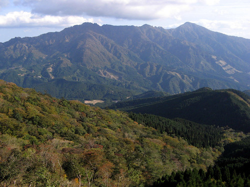
Mt. Ichifusa stands slightly apart from the otherwise densely packed Central Mountains, separated from its neighbors by deep valleys, it offers an airy view from its summit that is not to be missed by any half-serious hiker. Combine this with the fact that much of the middle and upper reaches of the mountains are covered with natural, undisturbed forest, and a relatively easy access from the nearby city of Hitoyoshi, it is no wonder Ichifusa is one of the most sought after summits in central Kyushu.
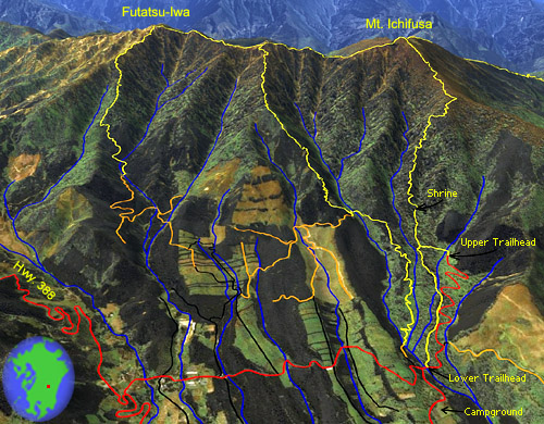
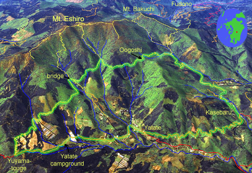
Better than average satellite land cover images, courtesy of JAXA, the Japanese Space Agency, have recently become available, enabling us to create this simulated 3-D view (as well as that of Mt. Eshiro in the previous entry). The extensive marks of human interference, but also the extent of these mountains’ remaining natural forests, are exquisitely visible in these images. Hiking trails are marked in yellow, dirt roads orange, paved roads black and red according to quality; data is from our own GPS surveying. In this view, the right-most trail is the standard, easiest and most popular route to the summit. Two trails lead down from the excellent and challenging cockscomb ridge traverse. One more trail descends on the Miyazaki side toward a trailhead in Nishimera village.
最近手に入れるようになったJAXAからの人工衛星で撮った画像を使ったこの立派な立体的な地図を作れた。植林を含めて人工のものがはっきり見える。残された原生林宇宙からでも目に優しい感じがする。登山道は黄色、砂利道はオレンジ色、それで舗装された道路が幅によって黒や赤で記録されています。道のデータは全部私達のGPS測量によるものです。この画像では、普通の登山道は表の右側の尾根に登る。二ツ岩までの稜線に縦走道もある。この稜線からあと二本の道は別々の尾根を下りる。裏側の宮崎県西米良村からも別の登山道がある。
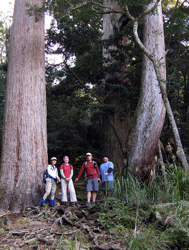
Large cedars line the initial part of the trail up to Ichifusa Shrine. Because the trees along the shrine trail are considered sacred, they are allowed to grow to full size.
 九州中央山地の話をもうちょっと続けましょう。先週末、江代山の直ぐ近くにある市房へ、紅葉を見る為に向けた。今回、二人のハイカーも連れてきた。市房山は、熊本と宮崎の県境に位置し、標高1721メートルで中央山地の一番高い山の一つだ。それで、地域の大分の山と違って、ほかの山から深い谷に分かれてかなり孤立しているから、頂上からの展望は非常に良くて印象的だ。しかも、山の中腹から頂上まで原生林が覆う、途中に景色も素晴らしい。人吉市からアクセスも簡単だ。だから、ハイカーのかなり人気がある山だと驚かないでしょう。
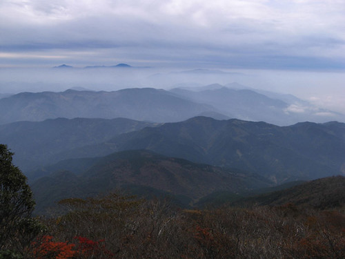
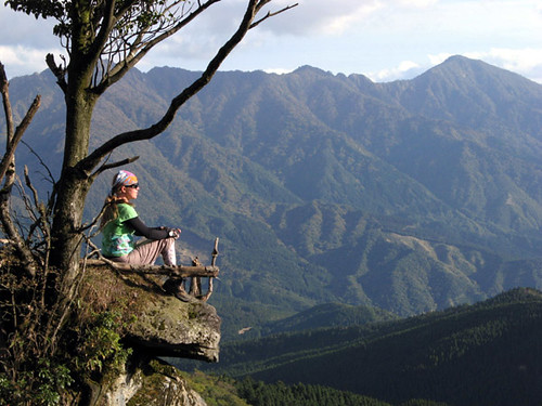
A view to the south from the summit. The distant Kirishima group of volcanoes can be seen above a layer of haze.
 The relative closeness of the trailheads to the summit of Mt. Ichifusa should not mislead prospective hikers into thinking it is a walk in the park. Although the standard route is only 3.8km long, it is steep most of the way, rising 1130m from the traihead at 590m to the 1721m high summit. (An alternative start exists from a higher trailhead at 790m, which also makes the hike about 800m shorter, but the small parking lot there tends to fill quickly on busy weekend mornings.) Any way you slice it, the ascent will be tiring and take about 1.5-3 hours. After climbing to the comfortably wide summit and enjoying the views and lunch there, experienced hikers can traverse a well-known, exposed and narrow ridge to Futatsu-Iwa (literally Two Rocks), a 1671m sub-summit located to the north-east. The 2.8km traverse involves a number of short but steep ups and downs; the former add up to 300m of vertical gain. Rope-equipped rope scrambles, slippery grass underfoot and the odd bit of third-classing over steep, loose landslides, which conspicuously cover this side of the mountain, will be encountered and the traverse can easily take 2-3 hours. From Futatsu-Iwa a trail descends 2.5km to an elevation of 940m from where dirt and paved roads can be followed for another 4.8km back to the original trailhead.
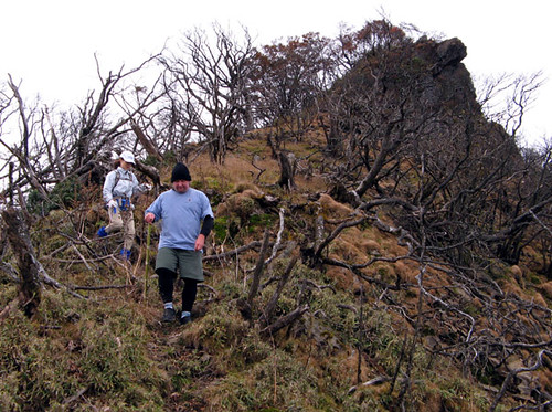
Carl and Kazumi, our companion hikers for the day, watch their footing on the slippery ridgeline trail towards Futatsu-Iwa.
市房山の頂上は、登山口に比較的に近いのに、登山の事は簡単とは言えない。距離はおよそ3.8キロだけだけど、その間1130メートルの標高差があるから、全体的に厳しい上り坂だ。もうちょっと上の別の登山口を使ったら、距離は800メートル、標高差は200メートルで減るけど、この駐車所は狭くて、週末の朝早く満車になっちゃう。とにかく、とっちの登山口を利用しても、登山の事はかなりきつくて、1.5-3時間かかるでしょう。頂上は広くて快適で、お弁当をたべながら素晴らしい眺めを楽しめる。ここから経験のあるハイカーは、二ツ岩までの縦走をチャレンジできる。二ツ岩は、標高1671メートルで、市房の頂上より北東側に位置し、頂上から狭い釣男ねがつながる。2.8キロの縦走はかなりアップダウンするので、合わせて300メートルの登りがある。しかも、ロープが付けた岩場、滑りやすい草の足元、跡はちょっと怖い土砂崩れの跡の横断もある。この障害物によって縦走は2-3時間もかかるでしょう。二ツ岩から降りると2.5キロの小道は、標高940メートルで林道に出会う。さらに4.8キロの道路歩きで、もとの登山口に戻れる。
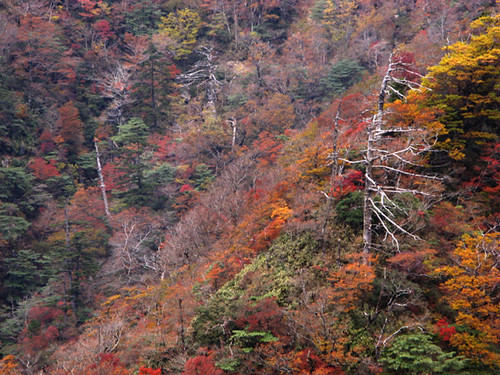
 The well known Futatsu-Iwa circuit has a lesser known, but nevertheless interesting variation. Just north of point 1642m, near the halfway point of the ridge, a branch trail descends along a steep ridge to the west. This time around, we decided to explore it on our descent from the mountain. And although by leaving the main ridge at this point, one avoids much of its difficulties and challenges, going this way has the advantage of returning straight back to the original trailhead, thus obviating the long walk on the roads. This variation is therefore considerably easier and takes perhaps two hours less time to complete, while still giving a taste of what the ridge is like. We recommend it to those who don’t want to return via the standard route but think the full circuit might be too scary or tiring. The descent itself was surprisingly delightful, taking us through some of the best fall scenery of the whole hike. It was also well marked and reasonably easy to walk.
よく知られている二ツ岩の縦走には、別の余り知られていないバリエーションがある。釣男ねのおよそ半分点で、1643メートルのピークのすぐ北側、別の小道は西にある尾根を目指して下る。今回、私達はこの道を下山で探検しようとした。縦走をここで止めるなら、その面白さや核心のチャレンジが消えるけど、この道の有利は、直接にもとの登山口まで降りれるから、道路の長い歩きもない。しかも、時間的にも少なくとも2時間早い。縦走の尾根の半分を歩けるから、頂上に登った普通の登山道を降りるよりずっと面白い。しかも、綺麗な原生林に囲まれた尾根を歩きながら、下山途中での見た紅葉はこの一日の一番綺麗だった。だから、二ツ岩まで行く勇気の無いけど、登山道を降りるのはつまらないと思っているハイカーに、この道を勧めます。普通に歩きやすくて、しるしや踏み跡もはっきりしているから、有る程度気をつけると迷わない。
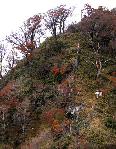
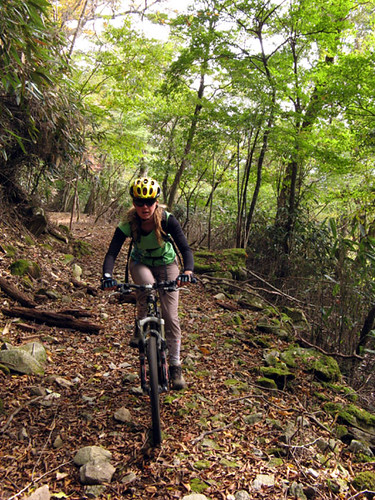
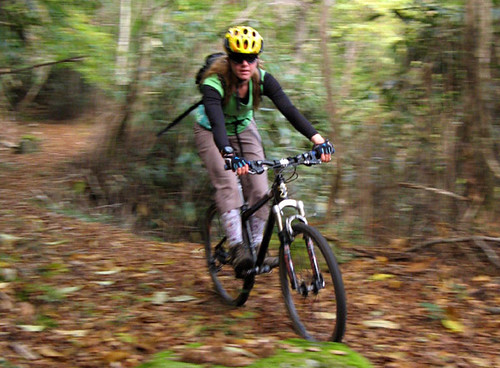
Kazumi and Leanne negotiate the steep ups and downs of the long ridge.
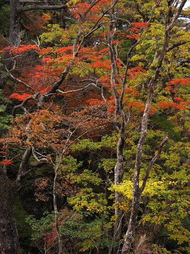
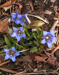
Pretty fall scenery along the alternative descent route.
 By now most of the leaves have fallen on Mt. Ichifusa, but the mountain remains interesting during any season. The summit and ridge area is much more exposed to winter storms than its lower reaches, and if one comes at the right time, one can enjoy spectacular rime ice and frost scenery near the summit while the approaches remain comfortably snow free. Seeing the snow-capped mountain from below is also an unforgettable scene. Such views can be seen from the village of Mizukami nestled just below the mountain, where natural hot spring baths await the returning hiker.
 もう今でも市房山で紅葉が消えたかもしれない。でも、この山はどの季節でも興味深い。冬の間、山のかなり空に突き出ている上部は周りより嵐に当たられて、頂上の付近はしばしば霧氷や雪に覆われている。運がよかったら、アプローチの道は雪なしで歩きやすくて、頂上の素晴らしい雪化粧の景色を楽しめる。下から眺めても、雪山の景色九州では普段に見えないから印象的でしょう。市房山の麓に位置する水上村から、こんな眺めができる。しかも、ドノ季節でも、山から戻っている疲れたハイカーには、村の天然温泉にも入りたくなるでしょう。
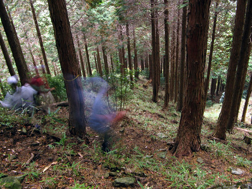
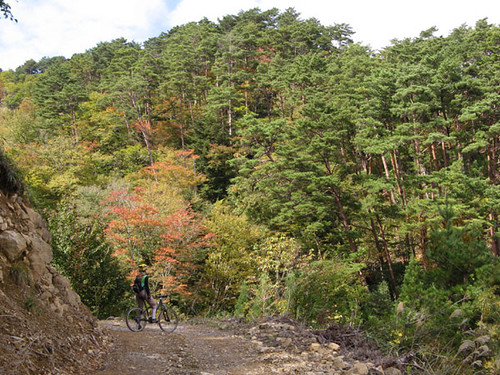
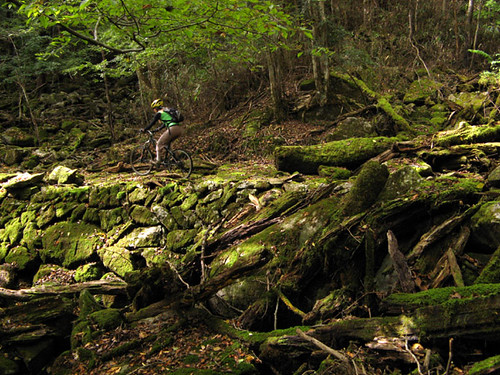
Descending down steep slopes through planted forest on the lower reaches of the mountain.
Mt. Ichifusa stands slightly apart from the otherwise densely packed Central Mountains, separated from its neighbors by deep valleys, it offers an airy view from its summit that is not to be missed by any half-serious hiker. Combine this with the fact that much of the middle and upper reaches of the mountains are covered with natural, undisturbed forest, and a relatively easy access from the nearby city of Hitoyoshi, it is no wonder Ichifusa is one of the most sought after summits in central Kyushu.
Better than average satellite land cover images, courtesy of JAXA, the Japanese Space Agency, have recently become available, enabling us to create this simulated 3-D view (as well as that of Mt. Eshiro in the previous entry). The extensive marks of human interference, but also the extent of these mountains’ remaining natural forests, are exquisitely visible in these images. Hiking trails are marked in yellow, dirt roads orange, paved roads black and red according to quality; data is from our own GPS surveying. In this view, the right-most trail is the standard, easiest and most popular route to the summit. Two trails lead down from the excellent and challenging cockscomb ridge traverse. One more trail descends on the Miyazaki side toward a trailhead in Nishimera village.
最近手に入れるようになったJAXAからの人工衛星で撮った画像を使ったこの立派な立体的な地図を作れた。植林を含めて人工のものがはっきり見える。残された原生林宇宙からでも目に優しい感じがする。登山道は黄色、砂利道はオレンジ色、それで舗装された道路が幅によって黒や赤で記録されています。道のデータは全部私達のGPS測量によるものです。この画像では、普通の登山道は表の右側の尾根に登る。二ツ岩までの稜線に縦走道もある。この稜線からあと二本の道は別々の尾根を下りる。裏側の宮崎県西米良村からも別の登山道がある。
Large cedars line the initial part of the trail up to Ichifusa Shrine. Because the trees along the shrine trail are considered sacred, they are allowed to grow to full size.
 九州中央山地の話をもうちょっと続けましょう。先週末、江代山の直ぐ近くにある市房へ、紅葉を見る為に向けた。今回、二人のハイカーも連れてきた。市房山は、熊本と宮崎の県境に位置し、標高1721メートルで中央山地の一番高い山の一つだ。それで、地域の大分の山と違って、ほかの山から深い谷に分かれてかなり孤立しているから、頂上からの展望は非常に良くて印象的だ。しかも、山の中腹から頂上まで原生林が覆う、途中に景色も素晴らしい。人吉市からアクセスも簡単だ。だから、ハイカーのかなり人気がある山だと驚かないでしょう。
A view to the south from the summit. The distant Kirishima group of volcanoes can be seen above a layer of haze.
 The relative closeness of the trailheads to the summit of Mt. Ichifusa should not mislead prospective hikers into thinking it is a walk in the park. Although the standard route is only 3.8km long, it is steep most of the way, rising 1130m from the traihead at 590m to the 1721m high summit. (An alternative start exists from a higher trailhead at 790m, which also makes the hike about 800m shorter, but the small parking lot there tends to fill quickly on busy weekend mornings.) Any way you slice it, the ascent will be tiring and take about 1.5-3 hours. After climbing to the comfortably wide summit and enjoying the views and lunch there, experienced hikers can traverse a well-known, exposed and narrow ridge to Futatsu-Iwa (literally Two Rocks), a 1671m sub-summit located to the north-east. The 2.8km traverse involves a number of short but steep ups and downs; the former add up to 300m of vertical gain. Rope-equipped rope scrambles, slippery grass underfoot and the odd bit of third-classing over steep, loose landslides, which conspicuously cover this side of the mountain, will be encountered and the traverse can easily take 2-3 hours. From Futatsu-Iwa a trail descends 2.5km to an elevation of 940m from where dirt and paved roads can be followed for another 4.8km back to the original trailhead.
Carl and Kazumi, our companion hikers for the day, watch their footing on the slippery ridgeline trail towards Futatsu-Iwa.
市房山の頂上は、登山口に比較的に近いのに、登山の事は簡単とは言えない。距離はおよそ3.8キロだけだけど、その間1130メートルの標高差があるから、全体的に厳しい上り坂だ。もうちょっと上の別の登山口を使ったら、距離は800メートル、標高差は200メートルで減るけど、この駐車所は狭くて、週末の朝早く満車になっちゃう。とにかく、とっちの登山口を利用しても、登山の事はかなりきつくて、1.5-3時間かかるでしょう。頂上は広くて快適で、お弁当をたべながら素晴らしい眺めを楽しめる。ここから経験のあるハイカーは、二ツ岩までの縦走をチャレンジできる。二ツ岩は、標高1671メートルで、市房の頂上より北東側に位置し、頂上から狭い釣男ねがつながる。2.8キロの縦走はかなりアップダウンするので、合わせて300メートルの登りがある。しかも、ロープが付けた岩場、滑りやすい草の足元、跡はちょっと怖い土砂崩れの跡の横断もある。この障害物によって縦走は2-3時間もかかるでしょう。二ツ岩から降りると2.5キロの小道は、標高940メートルで林道に出会う。さらに4.8キロの道路歩きで、もとの登山口に戻れる。
 The well known Futatsu-Iwa circuit has a lesser known, but nevertheless interesting variation. Just north of point 1642m, near the halfway point of the ridge, a branch trail descends along a steep ridge to the west. This time around, we decided to explore it on our descent from the mountain. And although by leaving the main ridge at this point, one avoids much of its difficulties and challenges, going this way has the advantage of returning straight back to the original trailhead, thus obviating the long walk on the roads. This variation is therefore considerably easier and takes perhaps two hours less time to complete, while still giving a taste of what the ridge is like. We recommend it to those who don’t want to return via the standard route but think the full circuit might be too scary or tiring. The descent itself was surprisingly delightful, taking us through some of the best fall scenery of the whole hike. It was also well marked and reasonably easy to walk.
よく知られている二ツ岩の縦走には、別の余り知られていないバリエーションがある。釣男ねのおよそ半分点で、1643メートルのピークのすぐ北側、別の小道は西にある尾根を目指して下る。今回、私達はこの道を下山で探検しようとした。縦走をここで止めるなら、その面白さや核心のチャレンジが消えるけど、この道の有利は、直接にもとの登山口まで降りれるから、道路の長い歩きもない。しかも、時間的にも少なくとも2時間早い。縦走の尾根の半分を歩けるから、頂上に登った普通の登山道を降りるよりずっと面白い。しかも、綺麗な原生林に囲まれた尾根を歩きながら、下山途中での見た紅葉はこの一日の一番綺麗だった。だから、二ツ岩まで行く勇気の無いけど、登山道を降りるのはつまらないと思っているハイカーに、この道を勧めます。普通に歩きやすくて、しるしや踏み跡もはっきりしているから、有る程度気をつけると迷わない。
Kazumi and Leanne negotiate the steep ups and downs of the long ridge.
Pretty fall scenery along the alternative descent route.
 By now most of the leaves have fallen on Mt. Ichifusa, but the mountain remains interesting during any season. The summit and ridge area is much more exposed to winter storms than its lower reaches, and if one comes at the right time, one can enjoy spectacular rime ice and frost scenery near the summit while the approaches remain comfortably snow free. Seeing the snow-capped mountain from below is also an unforgettable scene. Such views can be seen from the village of Mizukami nestled just below the mountain, where natural hot spring baths await the returning hiker.
 もう今でも市房山で紅葉が消えたかもしれない。でも、この山はどの季節でも興味深い。冬の間、山のかなり空に突き出ている上部は周りより嵐に当たられて、頂上の付近はしばしば霧氷や雪に覆われている。運がよかったら、アプローチの道は雪なしで歩きやすくて、頂上の素晴らしい雪化粧の景色を楽しめる。下から眺めても、雪山の景色九州では普段に見えないから印象的でしょう。市房山の麓に位置する水上村から、こんな眺めができる。しかも、ドノ季節でも、山から戻っている疲れたハイカーには、村の天然温泉にも入りたくなるでしょう。
Descending down steep slopes through planted forest on the lower reaches of the mountain.
Labels: hiking ハイキング
posted by Leanne and Rik Brezina at
12:49 pm
|
1 comments
![]()