Eshiro MTB ・江代山へマウンテンバイクで
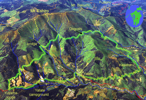
This simulated 3-D view shows our MTB circuit and also includes trail information gleaned from our surveys. Trails are marked in yellow, dirt roads in orange, narrow concrete-surfaced roads in black and (slightly) wider asphalt roads in red. The red line traversing the base of the picture is national hwy 388. 江代山の周辺の立体的な地図です。今回のMTBコースは緑色でマークされている。他には、測量した登山道や道路も乗せている。登山道は黄色で、砂利道はオレンジ色、そして車道は黒及び赤色で示してた。画像の下分を通る赤色の線は国道388号線です。
In our corner of Japan, mountain biking as such is virtually unknown. It follows that MTB-specific trail building and/or maintenance is also basically nonexistent. Nevertheless, in a mountainous yet populated place like Kyushu, with some effort, good riding can be found. One such place is Eshiro-yama, a mountain on the spine of Kyushu near the small city of Hitoyoshi. Last year, while surveying the hiking trails through the beautiful, protected natural forest that exists on the upper parts of this and other nearby mountains, we chanced on one trail that showed some MTB potential. This year, as the weather finally cooled down towards the end of October, we finally set out to ride it in its entirety. The verdict: it’s a good one!
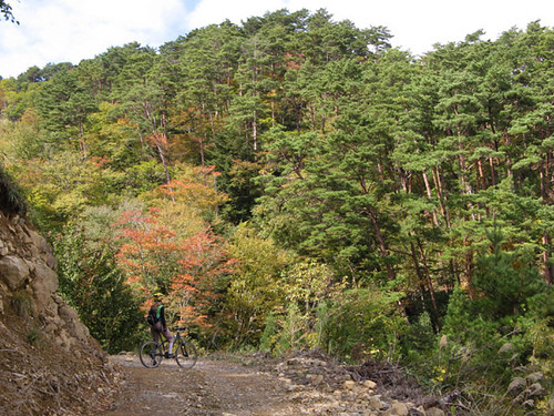
Admiring a mature stand of pine trees on the approach.
この辺では、MTBが余り知られていない。それによって、MTB専用のコウスや施設などもほとんどない。だけど、九州では山が多くて、そこに住む人々もいるから、すこし探せば、面白い山の道がある場所を見つけれる。その一つは、人吉市の近くの江代山です。去年、私達はこの山の付近にある美しい原生林を通るハイキング道を測量しながら、一本のMTBに良さそうな小道を発見した。今年の十月下旬、夏の残した暑さはやっと消えた後、この道に乗ろうとした。そして、かなりいい道だよ、と分かった。
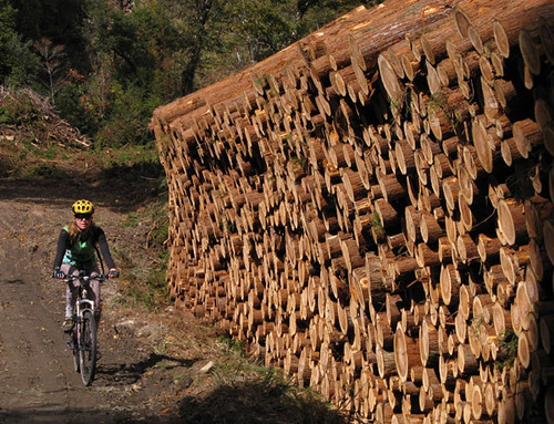
A part of the climbing section of the circuit leads up logging roads through planted forests. Here, Leanne passes a curiously stacked pile of lumber.
The course is best run as a counterclockwise, 16km circuit starting and ending at the Yatate Campground, in Shiiba Village, Miyazaki Prefecture, just across the prefectural boundary with Kumamoto Prefecture. The campground is at an altitude of 900m; except during the short summer season it is utterly deserted. The initial 5.2km of gently descending, paved, yet narrow and twisty road serve as a reasonable warm-up. The climbing then starts in earnest, following small, mostly unpaved roads that climb up into the mountain for 4.3km past fields and planted forests. The gradient increases even as road conditions worsen; the last 600m is a grade of nearly 20% on a bouldery 4x4 track that requires advanced skill and fitness to negotiate in the saddle.
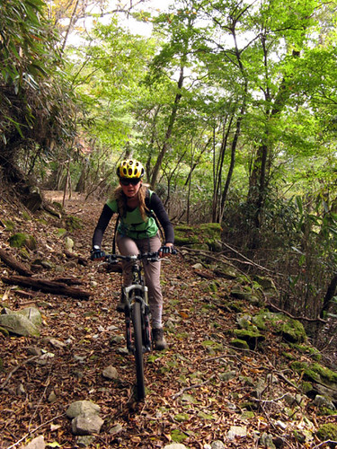
Finally on the singletrack!
Finally, a 1240m high point called Oogoshi is reached, and the reward for the arduous climbing can be reaped: 2.6km of delightful, gently descending singletrack through the deep woods. In one place, one can get a great view to the south of the imposing 1721m tall Mt. Ichifusa, and further along two excellent hiking trails lead up through rare virgin forest to the summit of the 1609m Mt. Eshiro, from where unrestricted views can be had over much of the central Kyushu highlands. Soon after the second trail junction the singletrack crosses a makeshift bridge and widens into a gravelly road. 2.8km of enjoyable downhill riding then lead to Yuyama Pass, from where another 1km of gentle descent on pavement leads one back to the campground.
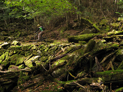
Rich shades of green and dappled sunlight are our companions on this trail through the deep forest. The trail was reinforced with stones when built into the steep mountainside a long time ago. Such pleasing and natural trail building is a rare find in Japan these days.
コウスは、左回りの16キロのサーキット。発着点は、熊本県堺に接する宮崎県椎葉村の矢立キャンプ場だ。900メートルの標高で、山に囲まれた綺麗な所なのに、夏休みしか人は滅多にいない。最初の5.2キロは緩い下り坂でうねうねした舗装された道は、適切なウォーマップになる。この地点で小さなコンクリートの道に左折すると本格的な4.2キロの登りが始まる。田舎風の田んぼに囲まれた民家を通るとすぐ舗装が消えて、ダートになる。しかもずっと急に登りながら、登るほど道は悪くなる。道の最後の600メートル程の20%に近い上り坂が、体のいい調子の上級者しか自転車で登れないと思う。やっと、大越と言う標高1240メートルの地点に着く。

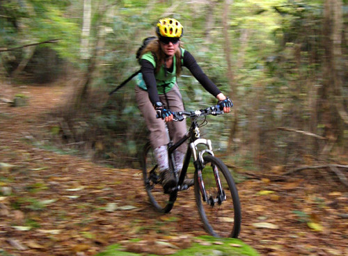
Mostly, the trail is an easy run but here and there mildly technical sections such as this one make for a fun diversion.
ここから、次の2.6キロのシングルトラックが、最高のものだ。少しずつ下がりながら、深い森を通って、一箇所には素晴らしい南に聳えている1721メートルの市房山の展望がある。前に進むと二本の登山道に出会う。余裕あれば、チヤリンコを残して40分程で、唯一の原生林を通って、1609メートルの九州ハイランドが全体見える360度の展望のある江代山の頂上に登れる。二本目の登山口を通ると、適当な橋があって、その後すぐ道が広くなってダートになって、さらに2.8キロの楽しい下りが続く。ダートは湯山峠で国道に出会う。この国道と思われない狭くてうねうねした舗装路を、快適に矢立キャンプ所まで降りれる。
The trail begins to descend a bit more steeply in the final part of the singletrack section, which can be taken at speed.
Because there are hardly any mountain bikers in the rural parts of this country, we enjoy nearly complete MTB freedom here. There are no signs prohibiting bikes on hiking trails or logging roads, and negative feelings from hikers or others are extremely unlikely. Besides, complaining is so very un-Japanese. Nevertheless, we do exercise certain cautions. As much as we can we ride gently on the trails. Because we always have Mondays off work, we preferentially use these to ride, as there are very few hikers. We avoid the short busy periods such as the fall colors viewing season or the flowering of some local plant, about which the locals can get pretty crazy. Using this stratagem, so far we’ve met exactly one person on the trails while biking; his reaction was to snap some pictures of us with his fancy digital camera, as if we were some rare form of wildlife. This being the prevailing attitude, it is unlikely that the over-use problems MTB faces many other countries will surface here anytime soon. But we still encourage anyone who might follow our blog into the wilderness to respect the spirit of minimal impact on nature and keep a low profile as we always do.

Nearing the summit of Mt. Eshiro on foot. Hiking through the well-preserved natural forest here makes for a pleasant excursion on its own.
二本の田舎は、MTBの愛好者は滅多にいないから、私達はMTBが完全な自由で楽しめる。ハイキングや林業の道にはMTBは禁止している標識などはなくて、ハイカーからの文句も受けた事がない。しかし、気をつけなくてもいいとも言えないと思う。道に乗る時、出来るだけ跡を残さないように乗る。ブレーキの下手のスキッドなどをしない。私達はラッキーな事で、日月の休みがあるから、普段にハイカーの少ない月曜日にMTBを乗る。しかも、紅葉、新緑、色々な花が咲くのハイカーが多い時期を避ける。この技で、今までMTBを乗りながら会ったのは一人のハイカー しかいない。その人の珍しい事が見えたらしいの反応は高価そうなデジカメで私達の写真を取っただけだ。大体このような態度は代表だろう。将来にも、他の国と違って、MTBにつくいろんな問題はこの辺で余り出ないかもしれない。それにかかわらず、もし誰かこのブロッグの指導で山へ向けたら、自然環境に優しく、そして多くの人に出来ろだけ見られないようにMTBをして欲しい。
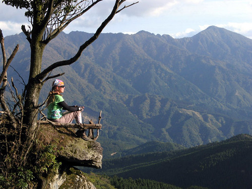
Leanne takes a break during a survey of the summit ridge of Mt. Eshiro. In the background is Mt Ichifusa with its long, high horizontal ridge draped in natural forest.
Labels: MTB
posted by Leanne and Rik Brezina at
1:16 pm
![]()


0 Comments:
Post a Comment
<< Home