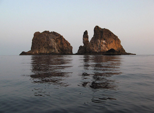
三島 - The Three Islands
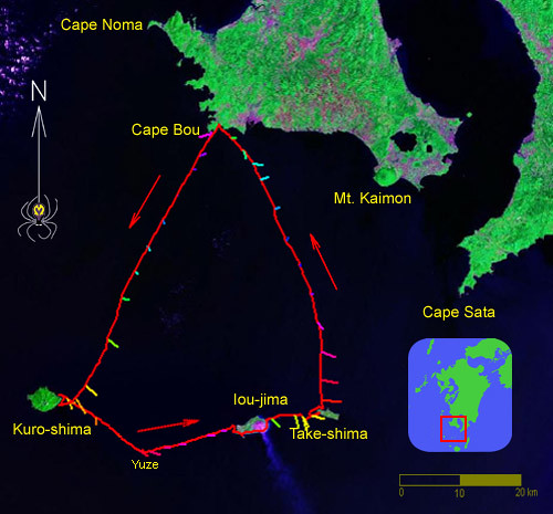
三日間の179kmの旅:鹿児島県の三島村。測定した流れが潮の状態によって色で表す。干潮は赤で、上げ潮が紫から青まで。満潮は水色で、下げ潮は緑から黄色とオレンジ色。流速は2ノットまで(竹島の北方)。この海域の流れは黒潮の強い影響を受ける。一般的に、三島の付近海流は東へ1ノットだけど、大分変わりやすいです。
Visiting the three islands of Mishima: 3 days, 179km. Measured currents are shown in colors corresponding to tidal phase: red is low tide; flood tide goes through purple and blue towards high tide (turquoise); green, yellow and orange represent the ebb tide. The strongest current encountered was 2.0 knots (north of Takeshima). Note that the tidal currents here are influenced by the Kuroshio current, which is quite variable but generally flows west to east at about 1 knot near the Mishima islands.
Late September in southern Kyushu generally still means midsummer weather, and the long weekend of the Autumnal Equinox (a national holiday) was to be no exception. We would have preferred slightly cooler conditions, but since we were granted three days off work on account of the autumnal equinox national holidays, we fully intended not to waste this rare opportunity. We set our sights on Mishima Village in Kagoshima Prefecture, a name which means, rather appropriately, Three Islands. Indeed, the village consists of three loosely spaced islands about 50km off the southern coast of Kyushu: Kuro-shima, Iou-jima, and Take-shima. With a total population of only about 450 people, virtually no stores and not a single drink vending machine, it’s the kind of place we really love to visit. We would be reunited with friends we made on our visit to Kuroshima last year, experience the steaming volcanic scapes of Ioujima with its dormant volcano, and take in the scenic rocky coasts of Take-shima as well as the other islands and rocks along the way. On Sunday and Tuesday we would do the traverses there and back, respectively, which would leave Monday to explore the archipelago. Two days of open-water paddling seemed a high price to pay to see these isolated specks of land, but the call of the unexplored in us was strong enough to overcome the monotony of the approach and return days. In retrospect, of course, it was worth it.
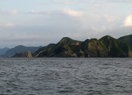
Cape Bou, the southwest end of Kyushu, was our point of departure and return.
坊岬、旅の出発点。
南九州の九月の下旬は、普段にまだまだ真夏の天気です。もっと涼しい天気が良かったけど、秋分の日の三日間の休みは私達にとって珍しかったから、この機会を有利に使う為に、鹿児島県の三島村を訪れようとした。当たり前の名前の付いた三島村は、三つのかなり離れた島を成す。黒島、硫黄島、と竹島は、九州の南海岸から50キロほど離れた、数キロだけの直径の島々です。合わせても、450人しか住まない。硫黄島意外小さな店もない。ドリンクの自動販売機もない。やはり、こんな所は、私達は訪れる事が好き。去年訪れた黒島で作った友達と又会うのは楽しみにしていた。又は火山の有る自然温泉に恵まれた硫黄島も非常に面白そうだった。竹島と途中にある色々な岩の小島も綺麗でしょうと思った。だから、日曜日は九州南西端の坊津から黒島の横断、そして火曜日は竹島から坊津までの横断をすれば、月曜日はこの島々を探検できるでしょう。この二日間のつまらなくて長い横断は島を訪れる為に捧げるのはどうでしょう。でも今まで行ってない所の探検は、私達にとって価値がある。やはり行って来たあと、寝不足と疲れ果てたのに、最高の旅だったと思ってきた。
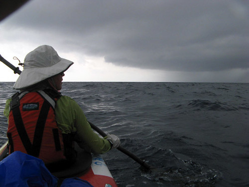
With a touch of apprehension Leanne surveys an approaching squall.
黒島への横断途中、スコールの前ちょっとだけ緊張している里杏。
The weather forecast looked reasonably good but our own conditions left a bit to be desired. On the morning of the day before our departure we got up very early to bike up a mountain in Amakusa well known as a milepost in the seasonal migration of goshawks from Siberia into the tropics. And on Saturday after work, we loaded the Waterfield "Whale Watcher" tandem on top of our tiny car (it was about twice the car’s length) and departed southward. Virtually sleepless for the second night in a row we arrived at Bounotsu on the southwest tip of Kyushu, our kayak departure point, at about 2am on Sunday morning. But we were too exhausted to embark just then on the difficult, long traverse, so we felt obliged to grab a few hours of sleep. But as soon as it got light we were on our way. The morning’s clear weather soon deteriorated and some rain showers made a rather dramatic approach from the northwest. At least in the downdraft of the first squall we got the opportunity to try the new oversize WindPaddle Cruiser sail specially designed for tandems and bigger boats. We were giving the sail a test run before sending it off to the Commando Team who would use it for their tour in their 4-person kayak designed for them specially by Mr. Mizuno of Water Field Kayaks. And though the wind was no more than 15 knots, the sail propelled our tandem at 6 knots or so – very respectable. Too bad the wind changed after only 30 minutes or so, leaving us to propel ourselves the rest of the way by our own paddle power.

Numerous waterfalls like this one drop down Kuroshima's cliffy coast.
黒島の海岸はほとんど岸壁で、滝が多い。
週末の天気予報は十分安定だったけと、自分自身の状態はちょっとやばかった。なぜなら、土曜日の朝は非常に早く起きて、天草の六郎次山って言う山に友達と一緒に自転車で登って、この時期だけで見えるアカハラダカの季節回遊を見に行った。そしてその日の仕事が終わったから、WaterField Kayakのホエールウォッチャー(タンデム)を傾斜に乗せて(船は車よりおよそ二倍の長さだった)、鹿児島へ向けた。二日目の大体睡眠なしで、深夜二時ごろ坊津に到着。直ぐ船を出す予定だったのに、疲れ果てで少し眠ようとした。長い横断の前、体を休ませた方がいい。とにかく、日が出たとすぐ船を出した。朝の晴れの天気は下り坂になって、午後に成ると雷が聞こえました。西から黒い前線の雲が近付いた。突然の風で、新しいウィンドパドル・クルーザーのタンデム用のセイルを出して試走が出来て嬉しかった。(この旅の後セイルをすぐコマンドのチームに送った。)15ノット程の風でも、私達のタンデムが漕げなくていい程度のスピードで進んだ。しかし30分後、風が止んで、又漕ぐしかなかった。
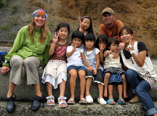
The welcome party at Kuroshima.
黒島へようこそ!
We arrived at Kuroshima in the late afternoon in gloomy conditions, but we were delighted to see our friends waiting for us. Of course, where else would they be on a Sunday on this tiny island, except in the port fishing. Not feeling especially tired, I went snorkeling with Mr. Eguchi, a local teacher and our friend, until it got dark, and was delighted to find clear water with many interesting fish to look at. In the evening we retired to Eguchi’s house and enjoyed an evening of drinking and chatting with several other school teachers. We stayed up a little later than we planned, of course, and were up again at 3am, an appropriate time, I figured, to catch favorable currents on our way to Ioujima. A cold wind was blowing but once we paddled out it became dead calm and much warmer – the wind had only been cool air descending from the 700m summits on the steep, mountainous island.
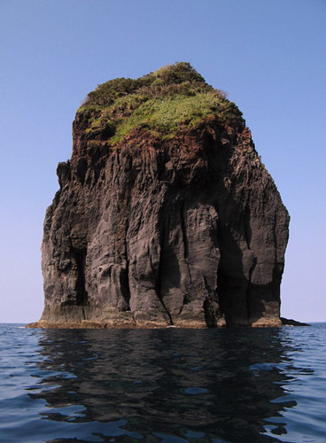
Yuze Rocks, also known as Den-shima, poke out unexpectedly from the sea halfway between Kuroshima and Ioujima.
釣り人の聖地のデン島。
Sunrise caught us as planned near the isolated Yuze Rocks located half-way between Kuroshima and Ioujima, and one of Kyushu’s more famous fishing spots. Atypically, the sea was calm and smooth as a mirror. For once the currents were turning out as expected and the rest of the 30km traverse also went smoothly and uneventfully. In late morning we were already enjoying the bizarre rocky formations along the western coast of Ioujima.
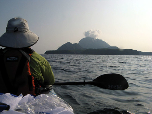
Approaching the volcanic island of Ioujima.
火山の有る硫黄島に近付く。
One of numerous scenic rock fomations along the western coast of Ioujima.
硫黄島の西海岸にあった立岩。
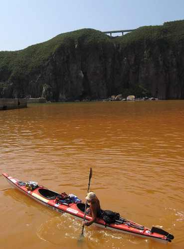
As we rounded the long, southward-projecting cape of Kuchinoerabu-saki, the water suddenly turned the color of mango juice. This was due to mineral rich volcanic springs scattered along the coast and the sea bottom along the entire eastern half of the island which is dominated by the steaming volcano. We made a lunchtime stop in the port and village where we met a friend of Mr. Eguchi's, who had been forewarned of our imminent arrival the night before. He told us interesting anecdotes about the island and showed us the village’s tiny museum of local artifacts. Through his assistance we were also able to check the weather forecast on the Internet, which continued favorable although a bit of swell from a distant typhoon would be coming in overnight. He kindly offered to drive us around the island to see the sights and tempting as this sounded, we realized we had to move along if we were to reach Takeshima comfortably before dark.
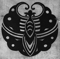
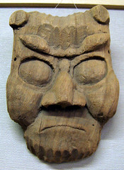
A family crest on display at the Ioujima village museum.
硫黄島の資料館にて。
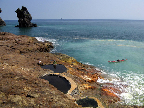
Underwater volcanic springs tint the seawater in Ioujima's port.
硫黄島の港で海底の温泉に染めた海水。
午後の五時ごろ黒島に到着。友達はもうずっと魚釣りながら港で待っていた。まあ、こんな小さな村は、日曜の暇は港で魚釣りしかないでしょう。そんなに疲れを感じなかったから、学校の先生の江口さんと言う友達と一緒に少しす潜っると、あっと言う間に外は暗くなった。江口さんの家で美味しい夕ご飯を食べて、ビールを飲みながら他の先生たちとのんびりの話をしました。勿論、予定より少し遅くまで起きて、少しだけ寝て、もう深夜3時に期待した流れに合う為に船を東へ向けて港を出た。黒島の付近は案詰めたい風が吹いていたけど、島からすこしだけ離れると風が止んで、又暖かく成った。矢張り島内の700メートルの高い山から下りてきた冷たい空気だったでしょう。日の出の時もう黒島と硫黄島の丁度真ん中にある釣り人によく知られた湯瀬(デン島)に着いた。海は凪で、人や船舶は全くいなかった。
Higashi Onsen - as far as hot springs go, it doesn't get much better than this.
最高の雰囲気の東温泉。
これから追い流れに乗ってこの30キロの硫黄島までの横断をかなり早く完成した。同島の西側の岸壁に着くとまだまだ朝だった。ここはいろんな面白い洞窟や立岩の小島があった。長くて南に突き出る口永良部崎を回ると突然海の色が変わってくる。まるでマンゴのジュースの色になった。これは、海底にある温泉のミネラルによって自然の現象だ。このような温泉は硫黄島で数箇所がある。それで島の頂上の硫黄岳の火山から、あちこちガスがでるのが見える。本当に素晴らしい景色だ。ランチを食べる為、島の港に入った。ここも海水はオレンジ色。防波堤やローカルの船の腹は、完全にこの色で染めていた。港で江口さんの友達にあって、彼は島の案内をしてくれて、島の資料館を勧めた。彼のおかげで、ネットでの天気予報もチェックした。天気の安定は続くけど、遠く南にあった台風の為のうねりは今から少し入ってくるそうだった。親切なXさんは車で島の案内を提供して、私達はちょっと悩んだ。行きたかったけど、そうすると竹島に夜まで着かないでしょう。今回はお断りにしましたけど、やはりいつか又戻って来ないといけない。
Under Ioujima's volcano, the coastal cliffs are stained by mineral hot springs.
温泉の水に染めている海岸。
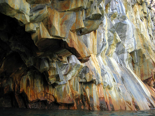
Before leaving Ioujima altogether we stopped at Higashi Onsen, one of several natural hot springs. Besides the manmade pools designed to catch the ample steaming hot mineral water gushing from cracks in the cliffs, there are no facilities and the use of the pools is free of charge. Unfortunately, it was the middle of a hot, blindingly sunny day and although we took a brief dip in the 44C water, it was much too hot to be truly enjoyable. We’ll have to come back in the winter! Anyway the scenery around the pools was wonderful, with views of the volcano, rocky coastline, and the open ocean. Continuing eastward along the coast, we saw multicolored cliffs and caves dyed by hot springs that seemed to issue out of every crack in the rock. It was like looking at a surrealist paining, and we’d never seen anything like it before. Several of the caves had a stream of hot water dropping straight into the sea from the ceiling. We would paddle through these curtains of hot water with great delight, thinking, what an incredible place this is, and incredulous that more tourists, be it kayakers or others, do not come here in greater numbers to enjoy it.

Hot water raining down from the cliffs.
頭上から落ちている温泉の湯。
硫黄島を完全に後ろに残す前、東温泉と言う所でも上がった。ここで、海岸に岩に人工的に湯舟が作られているけど、そのほか施設は無くて、利用も無料です。岩の隙間から、温泉水がたっぷり湧いてきます。この昼は日光が眩しくて、気温も熱くて44度の湯舟に入るのはきつかったから、ちょとっとだけ入った。冬の寒い日訪れたら最高でしょう。温泉の周りの景色は本当に素晴らしいくて、火山、海岸の絶壁、と太平洋の広い海原がみえる。又船にのって東に進むと、一流の岩の海岸が見えます。岸壁のあちこちの隙間から温泉が出て、岩がそれで超現実的な色に染められている。こんな事は始めて見た。洞窟の数箇所は天井から温泉水が落ち、通ると熱いシャワーを浴びる。こんなすごい所はなんでもっと観光客が訪れないでしょう。小笠原やハワイと同じ感じなのに。

The awesome scenery of Ioujima's volcano.
火山の風景。
On the relatively shorter traverse to Takeshima, we passed by the “New Ioujima”, a pillow of bizarrely sculpted lava that emerged out of the sea sometime in the 1920’s, very black and still completely devoid of plants. A little further on, we spotted a pod of dolphins swimming in an eddy line of the current, jumping playfully. The sea was glass smooth although the forecasted swell could now be felt a little. Takeshima, the flattest of the three Mishima islands, nevertheless has a steep, cliffy coast with now loomed in front of us. In a most unlikely place among some rock pinnacles, a small bay tightly surrounded by vertical 60-meter cliffs on three sides suddenly appeared and presented a claustrophobic harbor. Lit by the setting sun, it was a scene of great beauty and we felt tempted to camp here. A small concrete pier within the pristine landscape offered a convenient camping surface. A vertiginous staircase that zigzagged straight up the cliff above. After a relaxing swim we decided to climb out and look around the village; it was only then that we noticed the staircase was in great disrepair and barely passable. On the top was a historical sign describing the disasters that befell mariners from ancient times onward who were lulled by this deceptive cove. Once battering waves from the south block the narrow entrance, there was literally no way out and their boats were smashed against the vertical cliffs.

Approaching the deceptively flat-looking Takeshima.
遠くから見た竹島の比較的に落ち付いた様子。
比較的に短い竹島の横断途中、「昭和硫黄島」の小さい、奇岩怪石の小島を通る。この島は昭和時代の初めごろ海底での噴火によって海から出てきた。近く見ると島のほとんどは黒い溶岩から成って、土や植物は全く無さそうだ。竹島へ進むと流れがどんどん強くなって、フェリーグライドの状態で続く。途中丁度潮目が発生した所で、遊び中のイルカの群れを視認。竹島に近付くと流れによって延ばされた海の表面は油のように滑らかだった。しかし予想した台風のウネリは少しずつ感じて来た。竹島は、三島の三つの島の中で一番平らがあるのに、山は無いとも言えない。しかも海岸にどこでも急で高い岸壁が、目の前にそびえてる。その絶壁と数本の立岩の間、信じられない所に小さい湾があって、籠港(こもりこう)の閉所恐怖的な港を成す。夕日に照らされて、絶壁の白い岩が素晴らしい風景に魅入られて、湾の真ん中にあった便利で小さな波止場にキャンプしようと決めた。湾頭の裏に、目が回りそうな急階段が鉛直の岸壁に登る。ちょっと朱ノー家リングした後、上に登ろうとすると、階段がぼろぼろの状態に成っていると気づく。かなり崩れたや草が茂っていた部分が、ぎりぎり通ることが出来る。頂上に危険につき立ち入り禁止の標識の隣に、別の標識にこの籠港の歴史が書かれている。それによる、昔からここで嵐を避けようとして入った船、湾内にも波がひどく成った時出られなくなって、災害に会った。
Takeshima's flat interior is guarded by fearsome sea cliffs.
竹島の内陸を守っている男性的な海岸。
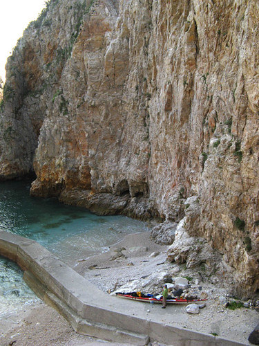
Komori-kou, a claustrophobic cove from where we would make a midnight escape.
素晴らしいけど、荒れた天気の時危ない籠港。
The seascape of vertical cliffs was a stark contrast to the plateau-like surface of the island interior. Impenetrably overgrown by a species of low bamboo – Take-shima means Bamboo Island after all – which had long ago choked out all other forms of vegetation, the only passable spaces here were man made. A network of rustic roads connected fields where the bamboo had been cleared. The small village was set into a slope which led steeply down to an unnecessarily large, concreted harbor on the island’s north side. As we filled our water bottles (the island’s tap water was surprisingly delicious) we met a diminutive old lady returning from the fields with a basket of freshly picked vegetables. We immediately struck up a bright conversation. It turned out she had come back on the ferry earlier today after visiting her ailing husband, who is confined to a care home in distant Kagoshima City, a world away. To visit there, we knew, is a small journey of several days, and we felt melancholy for her. But unflinching endurance of unthinkable hardships is one of the marks of the Japanese race, and this lively little old lady was no exception: not a shade of wistfulness showed in her eyes. In the meanwhile, darkness fell on the village; it was time to return to our private harbor. Once there, we pitched our tent halfway out on the jetty to avoid the possible hazard of falling rocks. But it was not to be the restful night we so badly needed. Sometime near midnight the swell increased and waves came crashing in noisily all around us. Finally one leapt clear onto the jetty and soaked half of our tent. Realizing that by morning the seas might be too high to launch into, and recalling the sign high on top of the cliff above us, we felt obliged to make a furtive escape in the darkness from this death trap of a harbor. Apprehensively, we prepared the boat and launched. Struggling with the surf among the dark cliffs, we aimed for the safety of the open sea. Once a safe distance from land, we followed the coast, rounded the island and made for the concrete port, where it was dead calm and quiet. After a short stroll to calm our nerves, we were able to get a couple more hours of shuteye before the sun came up.

Fuji-like Mt. Kaimon seen in the distance while returning to Kyushu.
「薩摩富士」を囲んでいる変な雲。帰り途中にて。
島の落ち付いた高原見たい内部は、海岸の男性的な風景と大きなコントラストがある。散らばっている畑や人工道以外、地上は突き抜けれない程茂っている竹に覆われている。うまく名前を付けられた島だ。島の小さな村は北へ向けている坂に位置する。北海岸への急坂を下りると、不必要ほど大きいコンクリートの港に出る。水筒に水道からいきなり美味しい水を満たすと取ったばかりの野菜を持った畑から帰ってきた小柄のおばあちゃんに会う。直ぐ話に花を咲かせた。実は、鹿児島市で入院しているだんなさんにお見舞いして、今日のフェリーで帰ってきた。この数日の旅に成るお見舞いは大変でしょうと私達は思って、ちょっと可愛そうな気持ちだった。でも日本人はすごい苦労を受けても我慢できるの人類である。このおばあちゃんも、なすびや大根についてはなしながら悲しみの面影が無かった。もう暗くなった道を歩いて、あの怖い階段を下りて、プライベートの港に戻る。落石を避ける為、テントを波止場の海側で張る。でも、寝不足を抑えるの為に必要な睡眠をこの夜も得ない。真夜中、ウネリがどんどん増えて、湾に入った波もどんどん煩く成る。結局一本が波止場に乗り上がって、テントを塗らす。ヤバイ!このウネリが増えている状況で朝まで待ったら、出れなく成るかもしれない。頭上の岸壁の標識が思い浮かぶ。真っ暗なのに、直ぐ逃げるしかない。急いで船に荷物を積んで、海に出す。狭い岩場に囲まれた湾の中でのサーフとの戦いの数分後、やっと安全な沖に出る。海岸から十分な距離を守って、島の岬を回って、完全に落ち付いた人工港に入る。少しの散歩で自分の心も落ち付いてくると寝る。日の出まで二三時間しか残っていない。
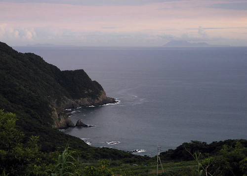
Takeshima and Ioujima seen on the distant horizon from near cape Bou.
坊津から見た遠くの水平線に浮かぶ竹島と硫黄島。
It was time to make our return trip back to mainland Kyushu. As expected, we had to work against the prevailing current. The forecasted headwind came in as well in the early afternoon. But it was an uneventful, if somewhat slow, traverse. About half-way across, a front with some light showers rolled through, clearing the hitherto hazy air like a stroke of a gigantic broom. One by one the surrounding islands re-emerged into sight, and soon the coast of Kyushu could be seen ahead, half-sunken under the horizon. Mt. Kaimon, a faithful ¼-scale replica of Mt. Fuji, loomed to the East draped with odd-shaped, multi-level, skirt-like clouds. Though exhausted by lack of sleep, mid-summer-like heat and the considerable distance we covered on this trip, our fatigue seemed to lift along with this curtain of haze. As we approached the coast at the end of our journey, we could not help thinking how lucky we were to have such amazing places available within the reach of the blades of our paddles.
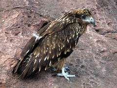
A juvenile kite encountered on the coast.
坊津の海岸にいたトンビのひよこ。
日が出ると、九州に帰る時間に成る。予想道理、最初から向かい流れに会う。昼ごろ向かい風も吹き始まる。これらの影響で50キロ程の横断は平均より遅いけど、何事も無く乗り越える。中程、にわか雨を伴う弱い前線が通ると突然、これまでの濃い靄が消えて、周りの島が一つ一つ再現。九州の海岸はまだまだ遠く、水平線から出ている山の上部しか見えない。「薩摩富士」の開聞岳の対称的な姿の回り、異様な雲が重なっている。寝不足とこの旅の長い距離や真夏のような暑さで疲れ果てた私達は、この案外の上がりに驚かせて、ちょっと元気が出ました。夕方海岸に近付くと、こんな素晴らしい所を週末でも行けると本当にラッキーな事でしょうと思いつく。
Labels: kayak expedition シーカヤック遠征
posted by Leanne and Rik Brezina at
8:18 pm
![]()


1 Comments:
Wicked hot springs! Looks amazing!
By Kootenay Mom and Dad, at 10:52 am
Post a Comment
<< Home