Part 3 Okinawa Kayak trip, Summer 2006
Map of the kayak trip.
We had planned to circumnavigate Kume-jima, which promises to be an interesting island: besides Okinawa, where we touched down so briefly, it is the biggest we would visit, and the most westerly. Off its west cape the warm Kuroshio Current -- the Pacific’s Gulf Stream -- flows through the deep open sea that forms the biggest break in the Ryukyu island chain between Kyushu and Taiwan: Miyako-jima, the next island, lies 220km away. Besides, the island has interesting reefs and topography including fresh-water springs in its seaside cliffs. On this trip with so many open crossings we had been looking forward to following a coast for a while. But we cannot afford the extra day the circumnavigation would take on account of the weather forecast, so we content ourselves with a minimal visit to the town of Madomari.
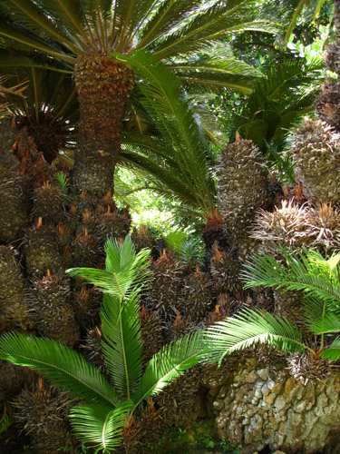
A lean and well-muscled fisherman is busy cleaning his net with a high-pressure hose at the port as we pull the kayaks up the boat ramp. When he hears where we came from, his surprise throws him in such a good mood that he gives us a lift to the local supermarket in his mini-truck. We buy breakfast and wander over to the nearby “giant sotetsu palm tree” marked in our map. This is actually in a private, meticulously preened garden around an old house, and being there we are once again taken in by the inescapable beauty and balance that always resides around a traditional Japanese dwelling. We talk with an elderly woman who had been gardening in the relative cool of the morning, then admire the tree. Sotetsu don’t grow very tall, so this one has spread itself horizontally in a wonderful, semi-chaotic tangle of its characteristic thick, spiny branches. Out of the shady nooks, several different kinds of ferns grow. The tree has created its own microclimate, and we forget how hot the morning is becoming until we step out of its shade.
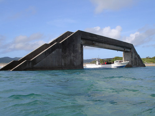
An artificial channel has been blasted through the eastern reef saving small vessels a 25km detour over frequently rough seas. Over this, a concrete bridge has been built, presumably for shell gatherers since much of the reef dries at low tide. Now at high water, the bridge looks strange, as if floating in the sea.
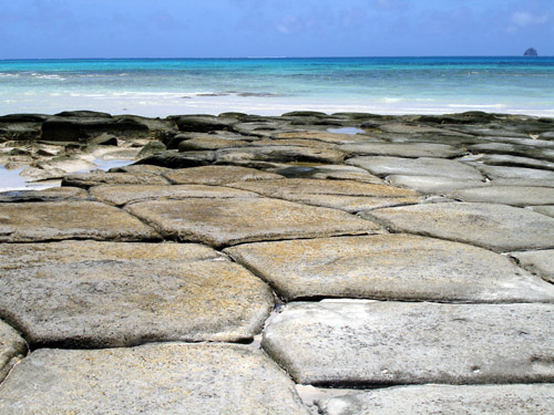
Kume-jima’s most touted tourist attraction is the so-called tatami (mat) rocks. Somehow the sea has effected a neat cross-section of a group of polygonal volcanic basalt columns; these make a curious sight against the pleasing backdrop of distant reefs and shallow lagoons with turquoise water. For good measure, additional attractions have been tagged on nearby, including a sea-turtle museum where turtles of several species can be seen swimming about in tanks. By now it is oppressively hot outside and we seek the museum for its air-conditioning as much as anything else. We hang out inside for a couple of hours. When we come out, it is very hot and we promptly feel the need to escape into the adjoining restaurant for a rather good gurukun grilled fish lunch and very overpriced shaved ice which did not compare in quality or quantity to the mini-truck restaurant’s at Tonaki.
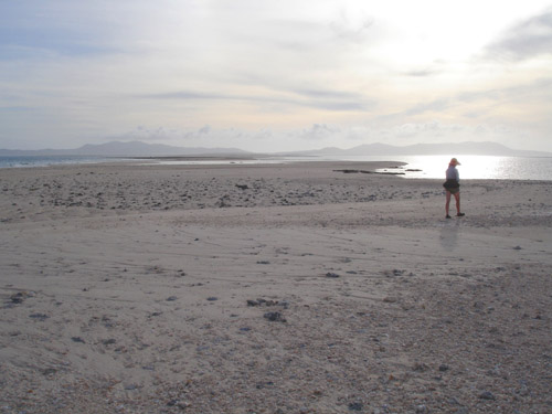
Finally, tourist traps exhausted, there was nothing else to do but to move on. It was getting late anyway, just enough time to make it back to the Ogan-saki lighthouse that we had passed in the wee hours of the morning. From there, we would strike out for Aguni-jima, the next island, 40km to the northeast. For 10km we navigate the twisting shallows and sandbanks in the interior of the huge reef; we had never seen such a place before. On the north side, the edge of the reef is above the water at low tide, a delicate but unbroken line stretching in a wide arc until it sinks below the horizon, giving the illusion of the lagoon opening to the sea. On the south side, the reef is broken and very complex, with many bays fringed by shoals, and occasional channels opening to the sea. It would be a delight to completely explore this complex, delicate landscape. Long sand spits had built up on top of some of the shoals; at low water, they are kilometers long but probably only a small portion remains dry at high tide. The sun is angling low in the sky when we land on the tip of the very last spit to survey the lighthouse, still 3km away, for camping possibilities. The binoculars reveal a concrete pedestal large enough to put the boats on in case the surrounding rocks go under water. Certainly we could not camp here on the spit: it still had wave marks from the previous high tide and the water is now rising rapidly.
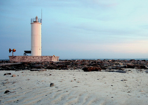
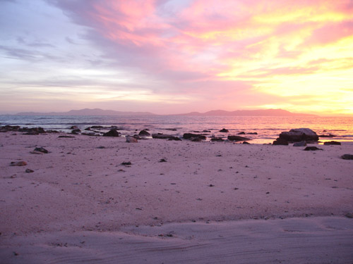
The lighthouse pedestal turns out to be a tad low but big enough, and there is even a helipad, only five feet above mean sea level (this is painted on it in large letters). It is of course big and flat, but perhaps not too prudent to camp on, the Japanese Constitution notwithstanding. There seems to be a distinct lack of high ground, besides the lighthouse. Furthermore, we are still inside the reef, and the lighthouse cannot be climbed to get a view of any breaks. So, amid a spectacular sunset, I paddle off in a hurry to check out a break about 2km away that we had seen on a satellite image. Big waves are breaking on either side but the break itself is deep and plenty wide to use as an exit. Carefully I mark it in the GPS, and hasten back in the gathering darkness. By nightfall the sea has obliterated all land except the helicopter pad, the lighthouse base, and the concrete walkway between them. By 9:30, the walkway is under water too. We are floating on a tiny, lonely, artificial island in the middle of the ocean, the nearest solid land many kilometers away. There are only the sounds and the smells of the sea, and the Milky Way shining brilliantly above. Schools of fish have invaded the briefly flooded land looking for forage, jumping crazily over the shallow rocks. We are there, so delicately safe, water now spilling over the low parts of the platform. All this is ours for a precious couple of hours. At 10pm, the water begins receding, and we grab a few hours of sleep. By 4am, we are navigating the break by GPS, dim outlines of waves crashing down around us in the darkness. Once free of the reef, we turn northeast toward Aguni, whose powerful, elevated light can already be seen above the waves.
We had planned to circumnavigate Kume-jima, which promises to be an interesting island: besides Okinawa, where we touched down so briefly, it is the biggest we would visit, and the most westerly. Off its west cape the warm Kuroshio Current -- the Pacific’s Gulf Stream -- flows through the deep open sea that forms the biggest break in the Ryukyu island chain between Kyushu and Taiwan: Miyako-jima, the next island, lies 220km away. Besides, the island has interesting reefs and topography including fresh-water springs in its seaside cliffs. On this trip with so many open crossings we had been looking forward to following a coast for a while. But we cannot afford the extra day the circumnavigation would take on account of the weather forecast, so we content ourselves with a minimal visit to the town of Madomari.
A lean and well-muscled fisherman is busy cleaning his net with a high-pressure hose at the port as we pull the kayaks up the boat ramp. When he hears where we came from, his surprise throws him in such a good mood that he gives us a lift to the local supermarket in his mini-truck. We buy breakfast and wander over to the nearby “giant sotetsu palm tree” marked in our map. This is actually in a private, meticulously preened garden around an old house, and being there we are once again taken in by the inescapable beauty and balance that always resides around a traditional Japanese dwelling. We talk with an elderly woman who had been gardening in the relative cool of the morning, then admire the tree. Sotetsu don’t grow very tall, so this one has spread itself horizontally in a wonderful, semi-chaotic tangle of its characteristic thick, spiny branches. Out of the shady nooks, several different kinds of ferns grow. The tree has created its own microclimate, and we forget how hot the morning is becoming until we step out of its shade.
An artificial channel has been blasted through the eastern reef saving small vessels a 25km detour over frequently rough seas. Over this, a concrete bridge has been built, presumably for shell gatherers since much of the reef dries at low tide. Now at high water, the bridge looks strange, as if floating in the sea.
Kume-jima’s most touted tourist attraction is the so-called tatami (mat) rocks. Somehow the sea has effected a neat cross-section of a group of polygonal volcanic basalt columns; these make a curious sight against the pleasing backdrop of distant reefs and shallow lagoons with turquoise water. For good measure, additional attractions have been tagged on nearby, including a sea-turtle museum where turtles of several species can be seen swimming about in tanks. By now it is oppressively hot outside and we seek the museum for its air-conditioning as much as anything else. We hang out inside for a couple of hours. When we come out, it is very hot and we promptly feel the need to escape into the adjoining restaurant for a rather good gurukun grilled fish lunch and very overpriced shaved ice which did not compare in quality or quantity to the mini-truck restaurant’s at Tonaki.
Finally, tourist traps exhausted, there was nothing else to do but to move on. It was getting late anyway, just enough time to make it back to the Ogan-saki lighthouse that we had passed in the wee hours of the morning. From there, we would strike out for Aguni-jima, the next island, 40km to the northeast. For 10km we navigate the twisting shallows and sandbanks in the interior of the huge reef; we had never seen such a place before. On the north side, the edge of the reef is above the water at low tide, a delicate but unbroken line stretching in a wide arc until it sinks below the horizon, giving the illusion of the lagoon opening to the sea. On the south side, the reef is broken and very complex, with many bays fringed by shoals, and occasional channels opening to the sea. It would be a delight to completely explore this complex, delicate landscape. Long sand spits had built up on top of some of the shoals; at low water, they are kilometers long but probably only a small portion remains dry at high tide. The sun is angling low in the sky when we land on the tip of the very last spit to survey the lighthouse, still 3km away, for camping possibilities. The binoculars reveal a concrete pedestal large enough to put the boats on in case the surrounding rocks go under water. Certainly we could not camp here on the spit: it still had wave marks from the previous high tide and the water is now rising rapidly.
The lighthouse pedestal turns out to be a tad low but big enough, and there is even a helipad, only five feet above mean sea level (this is painted on it in large letters). It is of course big and flat, but perhaps not too prudent to camp on, the Japanese Constitution notwithstanding. There seems to be a distinct lack of high ground, besides the lighthouse. Furthermore, we are still inside the reef, and the lighthouse cannot be climbed to get a view of any breaks. So, amid a spectacular sunset, I paddle off in a hurry to check out a break about 2km away that we had seen on a satellite image. Big waves are breaking on either side but the break itself is deep and plenty wide to use as an exit. Carefully I mark it in the GPS, and hasten back in the gathering darkness. By nightfall the sea has obliterated all land except the helicopter pad, the lighthouse base, and the concrete walkway between them. By 9:30, the walkway is under water too. We are floating on a tiny, lonely, artificial island in the middle of the ocean, the nearest solid land many kilometers away. There are only the sounds and the smells of the sea, and the Milky Way shining brilliantly above. Schools of fish have invaded the briefly flooded land looking for forage, jumping crazily over the shallow rocks. We are there, so delicately safe, water now spilling over the low parts of the platform. All this is ours for a precious couple of hours. At 10pm, the water begins receding, and we grab a few hours of sleep. By 4am, we are navigating the break by GPS, dim outlines of waves crashing down around us in the darkness. Once free of the reef, we turn northeast toward Aguni, whose powerful, elevated light can already be seen above the waves.
posted by Leanne and Rik Brezina at
11:48 am
![]()


0 Comments:
Post a Comment
<< Home