Cape Bou Kayak Trip
We are back from Okinawa. Nani yori mo buji desu (Japanese for- nothing is more important than returning safely). Our trip was great, challenging and full of excitement. I know everyone is waiting to hear about our trip, but for now enjoy this story about a trip around Cape Bou in Kagoshima Prefecture. We did this trip in June during the rainy season when the sea was calm and the rock outcroppings relatively easy to explore.
Our kayaking teacher and friend Kenji Suemitsu made a solo kayak traverse of southern Kyushu in early spring this year. He had bad luck with the weather, alternately meeting wind and rain along much of his way. Though he eventually cut his trip short we were duly impressed with his achievement, particularly the judgment he must have exercised of the conditions along the jagged and difficult coastline to meet with no accident.
Later, he told us one of his favorite sections of the traverse was the coast of Bounotsu, in the southwest extremity of Kyushu. Hitherto overlooked by us, this out-of-the way, infrequently visited corner of Kagoshima Prefecture indeed shows potential: steep mountains drop abruptly into the sea in a series of capes with intervening bays. A few days later I happened to hear on the radio that the town of Bounotsu has suffered over the last decade the greatest rate of depopulation in the prefecture. Its remoteness and lack of flat land for farming or building must be the reasons why. On a reasonably calm June weekend, we decided to check the place out. We were not disappointed in the scenic beauty, the clarity of the seawater, and abundance of wildlife along this coast; it is clearly one of the most attractive areas along the long, complex coast of the Kyushu mainland.
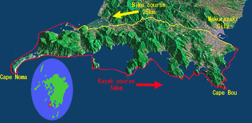
In Japan, covering distance by any means takes much time, money or both; Cape Noma is only 115km as the crow flies from our home in Hondo (on a very clear day its distant profile can even be made out from several Amakusa mountaintops), yet it takes no less than 5 hours, including a 30 minute ferry ride, to reach by car. The last ferry is a challenge to meet after work on Saturday. Leanne must rush out after her final class, jump on her bike and ride up the highway for about 12km while I meet her coming from the opposite direction, having taught in a small village on Amakusa’s west coast; the boats and equipment have already loaded onto and into the car. From previous experience, we knew that usually there is about five minutes to spare to catch the ferry at Ushibuka; however this time around we get blocked by a slow truck – passing is impossible and the driver (aargh!) won’t pull over for the entire 40km. Luckily, we have a cell phone onboard and call the ferry terminal; we are 4 minutes late but the ferry has waited for us.
Hours later, in complete darkness and pouring rain, we finally arrive near our planned departure point at the village of Kataura. The next challenge is to find a place to crash: the beach facilities are in utter disrepair. Eventually, we grab a few hours’ sleep under a gazebo at a roadside pull-off. At sunrise I spot the car to the city of Makurazaki across the peninsula where I find a convenient seaside park that will become our destination port, then ride my bike back along 25km of hilly road. Finally around 8:30am we are ready to go. The rain has stopped, and a clear vista slowly opens up around us as the mist lifts. We delight in the perfect conditions as we round the first rocky cape.
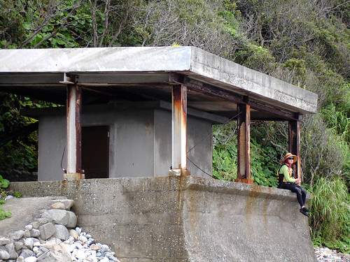
We stop at a bunker-like structure along the beach: it has a heavy roof like a bomb shelter and thick cables running in, but its exact purpose remains a mystery on an otherwise perfectly deserted beach.
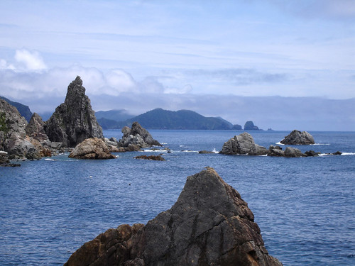
Soon we round the curving Cape Noma, with its weather-beaten rocks. The capes and islands of the rias coast ahead of us can be seen almost perfectly lined up from here. The Koshiki archipelago can also be seen distantly in the northwest while along the wide sweep of the southern horizon a few small isolated islands can be made out, including (populated) Iou-jima with its active volcano. The village of Noma perched delicately on the isthmus of the cape’s peninsula makes a convenient stop and we have lunch at its only open establishment. A wide range of expensive sashimi (raw fish) is on the menu reflecting the village’s fishing tradition and the fact that rich businessmen turned weekend sport fishermen are the most frequent visitors here. Efforts to invite others have been made and the village seems to have more museums than drink vending machines; as well as a tourist-trap statue of the fishing god Ebisu, which we do not go and see (we have a hulking one in Amakusa, reputedly Japan’s biggest, that took a million dollars to build). Do people really come here out of their way to see these things? Today, on a Sunday with fair weather, the village is quiet and seems deserted.
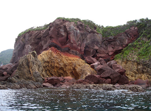
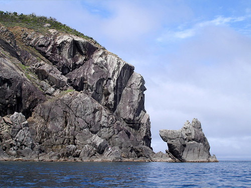
We return to our boats and navigate numerous rocky promontories, gliding between huge boulders within natural rock gardens. As we move south, lava and other, often brightly colored, extrusive rocks become evident. The scenery culminates in the cliffy coast of uninhabited Okiakime-jima, wild and unspoilt. Evening catches up with us at the entrance of Kushi Bay; following the coast for a short while we find a great camping place on top of a huge collapsing concrete buttress placed incongruously between a shallow beach and the encroaching jungle. The sea has underwashed this sloppily built structure; now it leans toward the waves at a superbly comfortable angle for sleeping. During the hour before nightfall, the only sign of life in the village within the bay was the distant sight of a public bus (no doubt passenger-less) climbing the precarious coastal road.
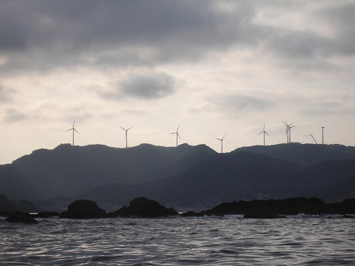
The next day only a relatively short section of coast around Cape Bou remained, so we paddled at a relaxed pace, exploring every nook and cranny in the rocks. The lava coast had ended and metamorphic rocks with their twisted layers jutted out of the sea. On the cape’s mountain ridge there is a growing row of wind turbines and, a lighthouse was placed high above the sea upon this southwest corner of Kyushu so that its light be visible from a great distance.
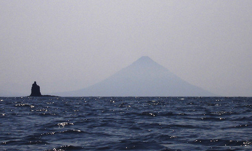
Rounding the tip of the cape, the spectacular Kaimon-dake (also known as the Satsuma Fuji) suddenly presents its perfect profile, offset by the slender pinnacle of Tategami Rock, itself a landmark of the Makurazaki coast. Kaimon is said to be “the most perfect imitation” of Mt. Fuji, the latter, to the Japanese, being the absolutely prefect epitome of a mountain. Although less than 1000m high, Kaimon is nevertheless well known across the country, and peak-baggers from Tokyo regularly come here to make the ascent.
Our kayaking teacher and friend Kenji Suemitsu made a solo kayak traverse of southern Kyushu in early spring this year. He had bad luck with the weather, alternately meeting wind and rain along much of his way. Though he eventually cut his trip short we were duly impressed with his achievement, particularly the judgment he must have exercised of the conditions along the jagged and difficult coastline to meet with no accident.
Later, he told us one of his favorite sections of the traverse was the coast of Bounotsu, in the southwest extremity of Kyushu. Hitherto overlooked by us, this out-of-the way, infrequently visited corner of Kagoshima Prefecture indeed shows potential: steep mountains drop abruptly into the sea in a series of capes with intervening bays. A few days later I happened to hear on the radio that the town of Bounotsu has suffered over the last decade the greatest rate of depopulation in the prefecture. Its remoteness and lack of flat land for farming or building must be the reasons why. On a reasonably calm June weekend, we decided to check the place out. We were not disappointed in the scenic beauty, the clarity of the seawater, and abundance of wildlife along this coast; it is clearly one of the most attractive areas along the long, complex coast of the Kyushu mainland.
In Japan, covering distance by any means takes much time, money or both; Cape Noma is only 115km as the crow flies from our home in Hondo (on a very clear day its distant profile can even be made out from several Amakusa mountaintops), yet it takes no less than 5 hours, including a 30 minute ferry ride, to reach by car. The last ferry is a challenge to meet after work on Saturday. Leanne must rush out after her final class, jump on her bike and ride up the highway for about 12km while I meet her coming from the opposite direction, having taught in a small village on Amakusa’s west coast; the boats and equipment have already loaded onto and into the car. From previous experience, we knew that usually there is about five minutes to spare to catch the ferry at Ushibuka; however this time around we get blocked by a slow truck – passing is impossible and the driver (aargh!) won’t pull over for the entire 40km. Luckily, we have a cell phone onboard and call the ferry terminal; we are 4 minutes late but the ferry has waited for us.
Hours later, in complete darkness and pouring rain, we finally arrive near our planned departure point at the village of Kataura. The next challenge is to find a place to crash: the beach facilities are in utter disrepair. Eventually, we grab a few hours’ sleep under a gazebo at a roadside pull-off. At sunrise I spot the car to the city of Makurazaki across the peninsula where I find a convenient seaside park that will become our destination port, then ride my bike back along 25km of hilly road. Finally around 8:30am we are ready to go. The rain has stopped, and a clear vista slowly opens up around us as the mist lifts. We delight in the perfect conditions as we round the first rocky cape.
We stop at a bunker-like structure along the beach: it has a heavy roof like a bomb shelter and thick cables running in, but its exact purpose remains a mystery on an otherwise perfectly deserted beach.
Soon we round the curving Cape Noma, with its weather-beaten rocks. The capes and islands of the rias coast ahead of us can be seen almost perfectly lined up from here. The Koshiki archipelago can also be seen distantly in the northwest while along the wide sweep of the southern horizon a few small isolated islands can be made out, including (populated) Iou-jima with its active volcano. The village of Noma perched delicately on the isthmus of the cape’s peninsula makes a convenient stop and we have lunch at its only open establishment. A wide range of expensive sashimi (raw fish) is on the menu reflecting the village’s fishing tradition and the fact that rich businessmen turned weekend sport fishermen are the most frequent visitors here. Efforts to invite others have been made and the village seems to have more museums than drink vending machines; as well as a tourist-trap statue of the fishing god Ebisu, which we do not go and see (we have a hulking one in Amakusa, reputedly Japan’s biggest, that took a million dollars to build). Do people really come here out of their way to see these things? Today, on a Sunday with fair weather, the village is quiet and seems deserted.
We return to our boats and navigate numerous rocky promontories, gliding between huge boulders within natural rock gardens. As we move south, lava and other, often brightly colored, extrusive rocks become evident. The scenery culminates in the cliffy coast of uninhabited Okiakime-jima, wild and unspoilt. Evening catches up with us at the entrance of Kushi Bay; following the coast for a short while we find a great camping place on top of a huge collapsing concrete buttress placed incongruously between a shallow beach and the encroaching jungle. The sea has underwashed this sloppily built structure; now it leans toward the waves at a superbly comfortable angle for sleeping. During the hour before nightfall, the only sign of life in the village within the bay was the distant sight of a public bus (no doubt passenger-less) climbing the precarious coastal road.
The next day only a relatively short section of coast around Cape Bou remained, so we paddled at a relaxed pace, exploring every nook and cranny in the rocks. The lava coast had ended and metamorphic rocks with their twisted layers jutted out of the sea. On the cape’s mountain ridge there is a growing row of wind turbines and, a lighthouse was placed high above the sea upon this southwest corner of Kyushu so that its light be visible from a great distance.
Rounding the tip of the cape, the spectacular Kaimon-dake (also known as the Satsuma Fuji) suddenly presents its perfect profile, offset by the slender pinnacle of Tategami Rock, itself a landmark of the Makurazaki coast. Kaimon is said to be “the most perfect imitation” of Mt. Fuji, the latter, to the Japanese, being the absolutely prefect epitome of a mountain. Although less than 1000m high, Kaimon is nevertheless well known across the country, and peak-baggers from Tokyo regularly come here to make the ascent.
posted by Leanne and Rik Brezina at
11:23 pm
![]()


2 Comments:
HOLA LEAN Y RICARDO
MUCHAS GRACIAS POR LA FOTOGRAFIAS Y LOS COMENTARIOS QUE USTEDES HAN HECHO DE SU ULTIMO VIAJE, TANTO LAS FOTOGRAFIAS COMO LOS COMENTARIOS SON EXCELENTES, ES COMO SI YO HUBIERA ESTADO CON USTEDES, FELICIDADES Y DONDE ESTEN CUIDENSE.
SU AMIGO LUIS GARZA
By Anonymous, at 1:20 am
Okinawa no repo wo tanoshimi ni shitemasu!!
By Jerremy, at 4:14 pm
Post a Comment
<< Home