July 24th Tanegashima
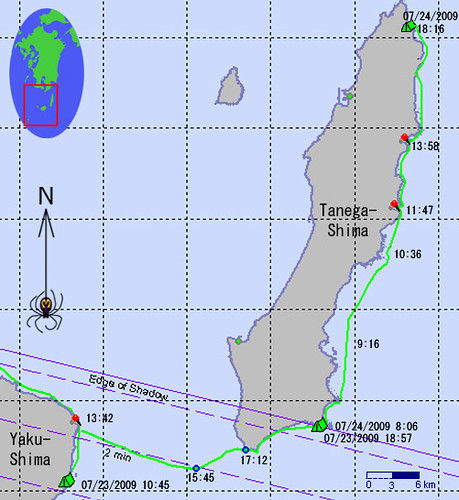
This map was made using data compiled from the SPOT tracking unit.
人工衛星を使うSPOTスポットと言うトラッキングシステムを使ってこの地図を作った。
Today looked like a great day for touring up the east coast of Tanegashima. This morning, at 8:20 the wind was measured at the Tanegashima lighthouse as 5m/s SSW. At 14:25 the wind was recorded as very light.
According to their SPOT records, it looks like they have finished kayaking for the day.
今日は種子島で最高なカヤックツアーの日でしょう。曇っているのでそんなに暑くないし風も弱いです。
奄美海上保安部の沿岸域情報提供システムのデータで種子島の西浦灯台は今朝8時20分南南西の風、風速5m/s、現在14:25頃風弱く. スポットによると今日午後6時ごろ漕ぎ終わった。
Do you want to follow this expedition on your own through the SPOT service (it's free!)? If so click here for live updates.
自分で二人の遠征をSPOTスポットでトラッキングしたいですか? ただですよ!ここで見てご覧ください。
Labels: kayak expedition シーカヤック遠征
posted by Leanne and Rik Brezina at
3:39 pm
![]()


0 Comments:
Post a Comment
<< Home