Eclipse Tour 日食ツアー
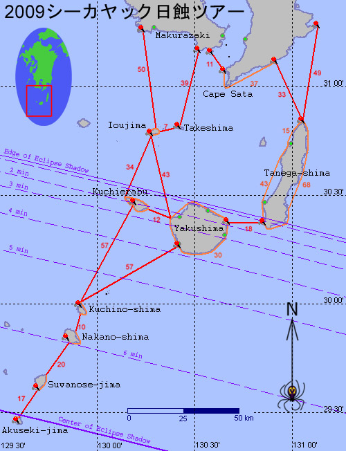
この地図は遠征海域の色々なポイントの間の距離を表します。現在予備予定で枕崎の周辺を出て、硫黄島・口永良部島経由トカラの口之島まで。帰りは黒潮の流れを有利に使って、屋久島・種子島を通って大隈半島です。 A map outlining the expedition's preliminary plans, showing distances in kilometers between various strategic points. We plan to leave Kyushu near Makurazaki and head toward Tokara's Kuchinoshima via Iojima and Kuchierabu-jima. On our return, to use the Kuroshio current to advantage, we will pass Yakushima and Tanega-shima toward an eventual landfall somewhere on the Osumi Peninsula.
2009年7月22日21世紀の一番長い6分39秒の継続時間の皆既日食が日本南近海から観測が出来ます。リックは関東の日本でよく知られているカヤッカーの城後さんと一緒にウォーターフィールドカヤックス社長の水野さんに供給したホエールウォッチャーのタンデムカヤックで7月19日から九州の南海岸からトカラ列島までこの日食を見るために漕いで行く予定です。GPSなどの人工衛星を使うSPOTと言うトラッキングシステムを使って、サポートチームが毎日の遠征の進行についてこのブログでアップデートされる予定です。
On July 22nd 2009, there will be a total solar eclipse lasting up to 6 minutes and 39 seconds. The Tokara Islands are one of the best places in Japan to view the eclipse. Rik and Jogo, an acclaimed kayaker from the Kansai area will travel together in a tandem kayak from the mainland of Kyushu to the Tokara islands. They will be paddling a Japanese made tandem kayak generously supplied by Waterfield Kayaks. SPOT Satellite GPS messenger technology will be used to track the progress of the expedition. This blog will be updated daily with their progress.
Labels: kayak expedition シーカヤック遠征
posted by Leanne and Rik Brezina at
9:14 pm
![]()


0 Comments:
Post a Comment
<< Home