Fishing in Kata Shima
Kata-shima, in Amakusa's south-west extremity, is the archipelago's most isolated (and uninhabited) islet, lying about 5km off the Ushibuka coast. Although the main islet is barely a quarter-kilometer across, it is surrounded by numerous above and below-water rocks and shoals. Particularly remarkable and unique in Amakusa is the massive shoal system extending for about 2km to the north. Here there are virtually no rocks that break the surface: apparently two very isolated tips just poke out at spring low tides but we've never seen it happen. The shoals are teeming with wildlife and as they are completely inaccessible to from shore, they're basically virgin territory for fishing. The only trouble is anchoring the boats, donning snorkel gear while fighting the current and the waves, and the fear factor of being truly out in the open. So while we often thought about spearing here, it wasn't until today that we actualized our plans. The result was a quick windfall.
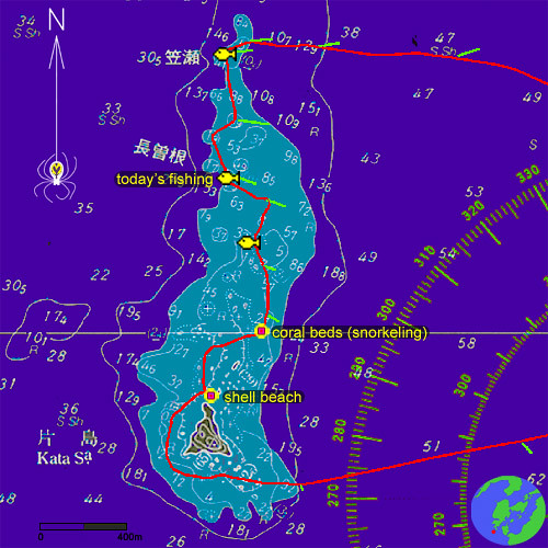
The official Japanese sea chart showing the neighborhood of Katashima. Note the extensive shoals to the north of the islet. Our most recent excursion is shown also (in red), with current measurements in green (currents are highly variable; this time they were ESE setting at up to 1 knot). The fish icon shows areas scouted to be particularly rich in large fish. A good snorkeling/diving spot is also shown, as well as where to find the nicest shells in Amakusa.
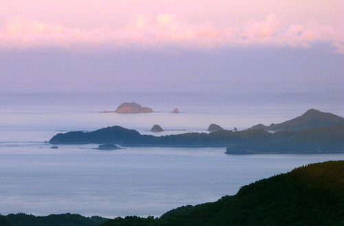
The rising sun lights up Katashima first, in this distant view from Naga-shima's Mt. Gyounindake. The southernmost tips of Amakusa are seen emerging from the night's shadows; the perspective is deceiving but actually these are 5-8km closer to the camera. Gesu-shima, Futago-jima, Tsukino-shima, Oko-ze, and Houga-shima - kayaking, fishing, and snorkeling hot spots in their own right, are all visible.
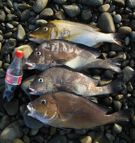
Today's catch is four fish at 1kg each, of two different kinds, both locally considered top notch in taste. Although the fish were in deep water (15-20m), they were so easy to spear that we called it quits after only 30 minutes. Plenty more are left. This is a spot not often fished, and has some of the cleanest water around (transparency was about 20m today). Probably these fish have not gorged themselves on whatever that stinky goop is the sport fishermen use for bait, so they are bound to be clean and delicious.
 After an awkward mid-ocean, mid-current spearing session (during which the kayaks were left bobbing on the surface, tied to some table coral 6m down), we stop at the Katashima beach to clean the fish.

The beautiful shoals and cliffs of Katashima. Amakusa exploring does not get any better than this.
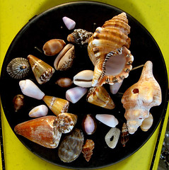
The beach, although tiny, always rewards us with beautiful shells of all kinds. Lately, more and more tropical species are in evidence, perhaps due to global warming. It is also said that the coral here is increasing (for the same reason), while in more southern locations such as Okinawa the warmer water is killing the reefs at an alarming rate. Maybe someday, we'll have bona fide coral reefs here in Amakusa!
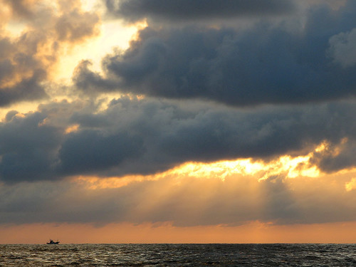
Time to be heading back as the sun sets behind the East China Sea.
The official Japanese sea chart showing the neighborhood of Katashima. Note the extensive shoals to the north of the islet. Our most recent excursion is shown also (in red), with current measurements in green (currents are highly variable; this time they were ESE setting at up to 1 knot). The fish icon shows areas scouted to be particularly rich in large fish. A good snorkeling/diving spot is also shown, as well as where to find the nicest shells in Amakusa.
The rising sun lights up Katashima first, in this distant view from Naga-shima's Mt. Gyounindake. The southernmost tips of Amakusa are seen emerging from the night's shadows; the perspective is deceiving but actually these are 5-8km closer to the camera. Gesu-shima, Futago-jima, Tsukino-shima, Oko-ze, and Houga-shima - kayaking, fishing, and snorkeling hot spots in their own right, are all visible.
Today's catch is four fish at 1kg each, of two different kinds, both locally considered top notch in taste. Although the fish were in deep water (15-20m), they were so easy to spear that we called it quits after only 30 minutes. Plenty more are left. This is a spot not often fished, and has some of the cleanest water around (transparency was about 20m today). Probably these fish have not gorged themselves on whatever that stinky goop is the sport fishermen use for bait, so they are bound to be clean and delicious.
 After an awkward mid-ocean, mid-current spearing session (during which the kayaks were left bobbing on the surface, tied to some table coral 6m down), we stop at the Katashima beach to clean the fish.
The beautiful shoals and cliffs of Katashima. Amakusa exploring does not get any better than this.
The beach, although tiny, always rewards us with beautiful shells of all kinds. Lately, more and more tropical species are in evidence, perhaps due to global warming. It is also said that the coral here is increasing (for the same reason), while in more southern locations such as Okinawa the warmer water is killing the reefs at an alarming rate. Maybe someday, we'll have bona fide coral reefs here in Amakusa!
Time to be heading back as the sun sets behind the East China Sea.
posted by Leanne and Rik Brezina at
9:59 am
![]()


3 Comments:
Can you tell me anything more about the name Katashima? Katashima is my husband's family name and not a very common one! We are looking into the name's origin for our own family history. And by the way, my own maiden name Payton, which I also noticed in your blog.
Patty Katashima nee Payton
By Pattykat, at 2:16 pm
hi patty.
according to our data, there are only 320 families in Japan with this last name. Indeed it is a fairly rare last name.
As for geographical locations, there are 15 places in total with this name, 8 of which are villages and 7 are islands. One interesting thing is that all these places are found in western Japan, specifically west of Osaka.The locations of the villages and islands don't seem to be at all related. I have a map of Western Japan with all these locations market which I can send you if you let me know your email. On the map the villages appear as small green circles and are coded V1 to V8. The islands appear as mountain symbols and are coded I1 to I7. The Katashima we visited is I3 (by the way). I apologize for the poor quality of the map.
Hope this is of some help. Good luck in your search!
By Leanne and Rik Brezina, at 10:37 pm
I would appreciate your map, I just hope you have not gone to any trouble to make and mark it up for me!
My email is tompatty@prodigy.net.
Thanks!
Patty in San Diego
By Pattykat, at 12:27 am
Post a Comment
<< Home