Please refer to other entries for the full story.
PART 1 Across the Sea to Yonaguni - 与那国まで海を渡って PART 2 This is Yonaguni - これは与那国PART 3 Pacific Atlantis - 与那国の海底遺跡Hello everyone. We're back from our ten day vacation from Okinawa, and what a great time it was. Adventure, beauty, pristine nature, eye-opening learning experiences, fun, new friends... one could not ask for anything more. But before we get started on this one, we'd like to point out to you that from now, we will be including Japanese text as well for the benefit of the folks in whose country we are living. If your computer does not have Asian fonts loaded, the Japanese will likely appear as garbage on your screen. If that is the case we apologize to you (on behalf of Bill Gates, really) for the corresponding degradation in the aesthetic quality of our blog. If you really want to, you can load the fonts for free...instructions are available with Windows. Then again, if you can actually read the truly hieroglyphic Japanese script, you probably have the fonts already.
こんにちは皆さん。たくさんの人のリクエストによって、これから日本語も頑張っています。変な言葉ちょっと許して下さい、私達は本の外人だから。これも勉強に成るかもしれないから、途中少しずつ上手に成ると祈ります。
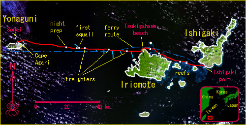 A summary map of the Yaeyama Islands and our Ishigaki to Yonaguni 2-day traverse (background image courtesy of LANDSAT - the ever-present cloud buildup probably cannot be helped). After an initial 47km day darting in and out of coral reefs, we landed on Iriomote Island's Tsukigahama. The next day we tackled an 82km open sea traverse to Yonaguni. Markings on the map are mostly self-explanatory and many refer to events described below. The turquoise lines during the first half of the open-sea traverse are measured currents (the fastest was about 2 knots); during the latter half we did not have the luxury to take further measurements, but currents seemed to have been more or less north-setting, 1 to 2 knots.
今回の横断の地図です。画像はLANDSATです。一日目、石垣港から、西表島の月が浜まで、47キロ漕ぎました。二日目は、与那国の祖内港まで82キロでした。地図の上のコメント等は、話に出るものだから、ちょっとだけ頑張ったら、分かると思います。あとは水色のラインは、海流の方向とスピードを現します。スピードは1-2ノット程でした。横断の後半は、測定出来ませんでしたが、大体北への流れで、2ノットまでだったと見られます。
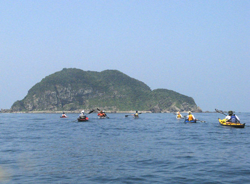
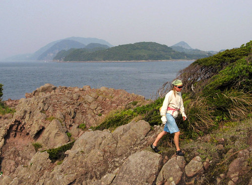
 On the first day, we made a few brief but interesting stops, including this one at Suna-jima, a small spontaneous sand spit among the extensive reefs between Ishigaki and Iriomote. The group rocks in the background marks the outer edge of the reef and, isolated as it is, forms an important natural beacon for all shipping approaching Ishigaki Port.
It’s 11am on only our second full day in Yaeyama, and we are already departing Iriomote Island’s beautiful Tsukigahama beach for a straight shot to Yonaguni, one of the most isolated of all Japanese inhabited islands, due west of us and 80km away. Up to this point it has been smooth going: flights to Ishigaki on Sunday, trying to look innocent inquiring about the ferry back (yes, we’ll take the plane there, we said), then Monday morning, picking up our boats from the shipping company’s warehouse, whose staff once again kindly dropped them off at the nearest boat ramp; then the seven hour, 47km traverse to Iriomote’s Unari Cape, darting in and out of reefs already well known to us. There was plenty of tail wind, giving us an opportunity to try our new
Wind Paddle sails, which worked beautifully: at the end of the day we really could not feel in our muscles the distance we had covered.
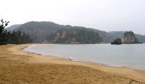 The beautiful Tsukigahama, seen here in a soggy condition, was our departure point for the big traverse. Although not the closest land to Yonaguni, the beach is strategic if approach is made from the north side of Iriomote, as was the case with us.
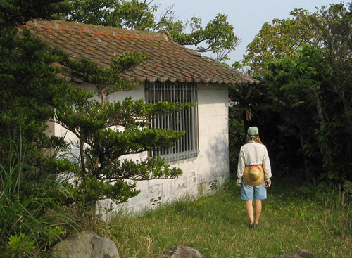
At night we met up with Chika and Saeko, our good friends and
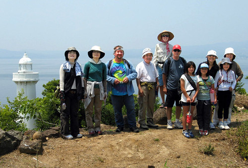
local kayak guides by trade, who once again offered us a tasty dinner, a place to crash out of the rain, and the all-important Internet weather check in the morning. And lo and behold, a moderate east wind is to hold for the day, much more favorable than the storm that had been forecasted the day before. Just like that we scrapped our tentative plans to poke around Iriomote’s wild northwest coast and decided to set out for Yonaguni straight away. Not having expected to go, we did get a late start. But a night paddle would have been inevitable anyhow, so new moon or not, we’ll deal with it, we said to ourselves.
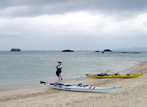
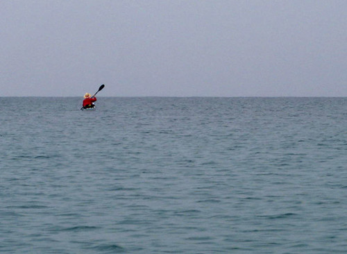 Leanne departs Tsukigahama towards Yonaguni, 80km beyond the horizon. The sea looks deceptively calm on this, leeward side of Iriomote Island.
石垣に飛行機で着くと、私達は帰りの為に与那国のフェリーの情報を確かめて、運輸会社(RKKさん)にここまで送ってくれたカヤックを受け取って(やさしい社員たちは今回もボートをスロープまでトラックで運んでくれました)、早速西へ向けて出艇しました。最初の日、西表島のウナリ崎までの47kmの横断の間、追い風があったから、新しい
WIND PADDLE「ウィンドパドル」というセール(帆)を使って、とても便利でした。セーリングしながら漕いだまま、その距離七時間で乗り越えて、筋肉も余り疲れていなかったのです。夜は、西表島でシーカヤックガイド「
ぱいしぃず」をやっている友達の家に泊まって、推参だったのに、美味しい食べ物をいただいて、外の降っていた雨を避けて、畳部屋で寝させてくれました。朝の大切なネットでの天気予報チェックすると、驚くほど、昨日まで予報された嵐が消えて、十ノット程の真東の風は予想されました。それを見ると、直ぐ与那国へ行こうと決めました。しかし、時間もう遅くてちょっと不便で、途中新月の夜の闇を避けないと見られました。でもドンマイ。実際の世界では、全部が理想ではないでしょう。
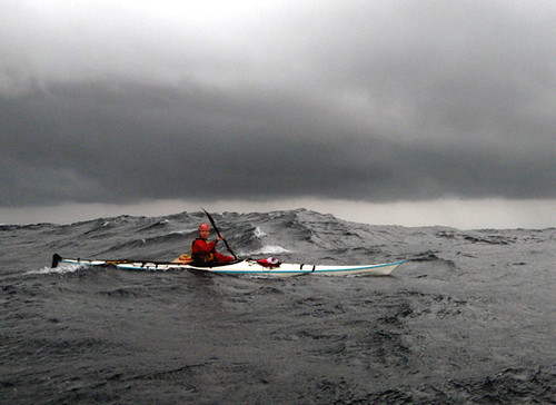
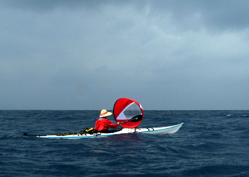 It's smooth sailing, for a while. Leanne tucks the sail's lanyard behind her head (the ears forming useful hooks) so that she can paddle as well. This way, we move along at 4 to 5 knots with very little effort.
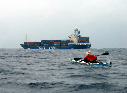 Shipping hazard. Busy smoothing the kinks out of our sailing, we neglected to look around for incoming shipping and let this Chinese freighter approach us from behind a little closer than we normally would have allowed. Sails were quickly stowed on the ship's approach lest their color attract the attention of the crew.
The Wind Paddles are deployed and, paddling along, we are making good headway in spite of a slight countercurrent that begins unexpectedly offshore after we cross a rather active eddy line. Almost right away we meet with shipping traffic; by Murphy’s Law we always seem to be on a collision course with some huge ship in spite of the immense size of the Pacific. So we pull some maneuvers to keep just outside spotting range of the overloaded Chinese freighter. A while later the wind dies, so we stow the sails and paddle energetically against the persistent current, still making reasonable headway. In spite of the calm, the sea is choppy, no doubt because we are at the meeting point of waves diffracting around both sides of Iriomote Island, which is now fading into the haze behind us. A Yonaguni-bound Boeing 737 glides directly overhead, perfectly aligned with our course – we’re both navigating well, it seems! For a jet, of course, the 124km between Ishigaki and Yonaguni airports is just a short hop, so it cruises easily overhead at mid-altitude with engines at half power.
西表の月が浜を十時半頃出て、又直ぐウィンドパドルを配備して、しばらく進行が早かった。途中潮目を越すと、流れはちょっと逆になったのに、セーリングとパドリングのお陰で影響はそんなになかった。早速大型船舶の航路に入って、過負荷した中国の貨物船を避ける為の手技を行った。普段、船舶のブリッジから見かけられない距離を出来るだけ守りたいです。太平洋は広いなのに、海を通る私達はデッカイ船と衝突する状態は期待より高くなりそうです。運が悪いかなあ。
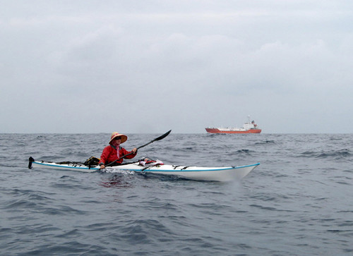 This is normally about the distance we let other ships pass us. Which country this one belongs to is not clear, but its name at least was English.
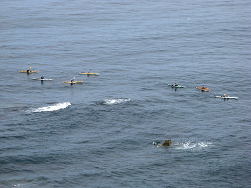
At the 25 km mark, we finally lose sight of the land behind us, and continue on surrounded by only the watery horizon, the occasional sight of another freighter, and inquisitive boobies who have had no trouble spotting us while surfing the wind wakes of the big ships. The choppy waves cross-hatching the sea continue to remind us of the land we left behind and I think of primitive navigators who could estimate the size of and distance to as yet unseen lands from the character of the waves, a skill that seems to come naturally while living with the sea. The counter-current presently quits altogether, and we continue on solely under our own power, the chop gradually calming down too. We’re wishing for the forecasted tailwind so we can unfurl our sails to effect. Sailing, the GPS ETA was about 10:30pm, but like this, we won’t make landfall until sometime after midnight.
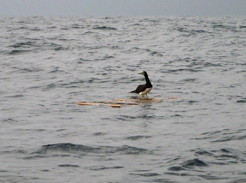 Inquisitive boobies taking a ride on the freighters' wind wakes often came to say hi. Boobies (as the name implies) are comical birds, ridiculously clumsy in their nevertheless undaunted efforts to catch flying fish. They dive into the sea after them in all the wrong places but we guess they don't float very well, which may be why this one found some flotsam to alight on, 30km from the nearest land.
しばらくすると、風と流れも止んで、セールを仕舞い込んで、力をだして漕ぎ続けた。海はまだまだ、波はけっこう残っていた。恐らく、後ろの靄に残された西表島の両側からの波、ここで再結合。陸が見えなくても、経験のある船乗りは、そこに島があるのを、波の状態で、はっきり知ることが出来ます。頭上、与那国行きの737のジェット機が、私たちのコースとぴったりせいれつでした。たぶん、私たちも、パイロットも、正しいコースを選びました。別の貨物船を通ると、好奇心のあるカツオドリが寄ってくる。この鳥が、私のカヤックの黄色が好きそうで、何回も何回も頭の上に回って飛びます。予想された東の風は中々吹いてこない。そのせいで、GPSで予報した到着時刻が十時半から深夜の零時ごろまで変化します。
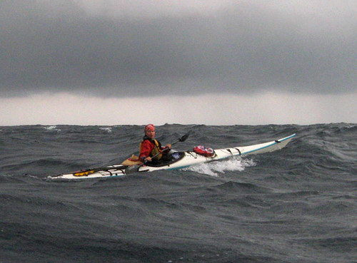
A squall that has been following us persistently finally moves through, with a fresh breeze following.
Sails come out but after 15 minutes or so, we’re ripping forward at such speeds that they need to be stowed again. We’re still novices at kayak sailing, and this does not seem to be the place or time to be testing our limits. Indeed, the breeze has reawakened the sea as well and now numerous white-crested waves comb the surface, while schools of 50 or more flying fish emerge specacularly from the wave faces, carving graceful, coordinated flight paths in the wind. Every now and then, a set of massive waves rolls through, requiring our undivided attention. Occasionally we’re swept sideways on a breaker, beach-landing style, until it gives up on trying to tip us, retreating ghostlike into the background of smaller waves from whence it came. All this is fine and good, and we’re being blown at a fast clip directly towards our destination, but we’re about to run out of daylight. We wait as long as possible to configure for darkness, hoping the squall will pass, but no such luck. In fact it seems we’re pretty much keeping up with it. So we raft up while I put on my dry top and life jacket (shed earlier to stave off overheating; Leanne had taken a swim). We also bail the boats and deploy lights, so as to be able to keep track of one another in the oncoming darkness.
 Daylight fades and squalls gather as we surf down the final few waves at breakneck speed, trying to make as much headway as possible before complete darkness descends, for then there will be no choice but to quit paddling, raft up, and drift along on the wind.
私達を持続的に追い掛けられたスコールはやっと私達に追いついた、風が再び吹いて来ました。
セールを出すと、どんどんスピードが上がって、そして十五分後もうセーリングを止めた方がいいの感じがする。ここで、どれぐらい耐えられるの実験は、ちょうど今行いたくないから、セールをまた片付けました。とにかく、海も再び起きて来ました。白い波が広がっていると共に、たまにデカイ波も寄って来るから、十分な集中が必要です。時々波頭に、丸でサーフビーチでのように横に流されます。しかしどうしてもひっくり返さないと、波が諦めるように、回りの小さい波の中に消えます。これは平気で、しかも、目的地まで早くながされているけど、もうすぐ暗くなるはずだ。夜の準備は多分スコールは止むの期待で、出来るだけ延期します。でも止むとは見られない、実は私達と同じスピードで進んでいる見たい。だから、私は前の暑さの為に外したドライトップと救命胴衣を再び着て、ビルジを出して、体にライトを付けました。ライトは真っ暗の状態でお互いを見られるためでした。
But as darkness slowly embraces us, it becomes evident that paddling will not be possible for much longer. The horizon grows fuzzy and it becomes annoyingly difficult to keep balance and a consistent heading. Leanne is surprised by a wave and briefly tips into the drink, reappearing on the surface in the blink of an eye – an expertly executed roll at a record distance – still more than 30km – from land. That does it – there is no choice but to raft up. This we do with an attendant feeling of warm comfort and stability. Soon it is pitch black, to the point where even the horizon cannot be made out whatsoever. All we can see are the phosphorescent white crests that roll around and over us; Leanne unwittingly anticipates the approach of one of the first, observing: “I think I hear a jet.” But there are no flights to Yonaguni at night, and overhead there are only black clouds blotting out the sky; even the sea can only be felt more than it can actually be seen.
でも、どんどん暗く成った時、もう漕ぎ続けないと見られる。なぜなら、水平線は不鮮明に成って、バランスをとると船の方向を守るのは非常に難しく成りました。里杏(リアン)は、一本の波にびっくりされて、ひっくり返します。しかし、あっと言う間に、船の姿勢を直します。こーれは、なんか記録だ、陸から30km離れた場所で。でもしょうがない、これからラフチングに成ります。すると、なんとなく快適で安定の感じがします。まもなく真っ暗の状態に成りました。水平線はどこにあるのも分からない。見えるのは、夜光虫が照らた、私達をたまに苛められている波頭。しらずしらず、里杏はその最初の中の一つの来た時、「ジェット機が聞こえるかも」と言います。でも、与那国までの夜の便はない。頭上見るより感じるだけの黒雲しか有りません。
 There is no need to be reminded to look out for the next big wave coming. Natural instincts take over. Preparations for nighttime complete, we hasten to shrink the distance between us and land in the fast-fading daylight.
Still, all is fine and good, though we get a little nervous anticipating what might happen if conditions were to get any worse. During the day, a sea like this wouldn’t be much trouble, but the challenges of complete darkness are making themselves felt. Controlling the heading of our raft is most important – we absolutely need to stay perpendicular to the biggest waves lest they bowl us over. The GPS heading is of no use as we’re being tossed this way and that, so we train a headlamp at the compass instead and aggressively maintain a heading due west with our rudders. We take turns at the compass, calling to each other, “Hard right! OK, straight!” like the crew at the bridge of some typhoon-molested ship. Big waves roll in regularly about every ten minutes, just like at a surf break; their roar gives ample warning of their coming. We have no problem holding on to each other as the crests wash over us, and we can pump the bilges occasionally in the relative calm between the sets. Every now and then we check the GPS, and our course is fine. The wind is blowing us straight into the island, at about half paddling speed. ETA now is about 4am.
でも、まだまだ平気です。ただ、もっとしけるとどうするについて、少し緊張します。昼だったら全く問題ないけど、真っ暗ではいろいろ難しい。大きな波にやられない為、船の方向のコントロールは一番大事です。波にあちこち投げられているから、GPSの表示している進む方向は、全く役に立ちません。その代わり、コンパスにヘッドランプを向けて、真西の向きをラダー(舵)で積極的に守ります。どうしてもでかい波と直度を守るべきだ。「ハード右!よし、まっすぐ!」など、コンパスをじっと見ながら、船乗りのように二人のラダーの動きを共同させます。 サーフィンのポイントと同じぐらいように、大きな波はおよそ十分ずつきて、その響きは警報として十分です。しぶきに囲まれた時も、お互いの船を持つのは問題ありません。そして、大きな波の間の落ちずいた時、ビルジも出せます。たまに、GPSをチャックすると、コースは全然大丈夫。風に島へ直接に流されているようだ。到着予想時刻は今、午前四時に変わりました。
Rain showers pass through and here and there lightning flashes, but in between squalls we finally catch sight of the Agarizaki lighthouse, now 20km dead ahead. With this sole landmark, maintaining heading instantly becomes easy; among our worries has been seasickness from staring at the compass. But we’re fine, though challenges remain: how to avoid the tidal races that are bound to occur around the island, and would we be able to hold our balance and paddle once more lights come into view? A brief early try shows that it’s still too difficult. Would it be better to turn into the storm and put on the brakes somehow to delay our arrival until daylight? Or let the wind blow us past the island, and then fight our way back once it gets light? The first option seems too difficult since we have no parachute (mental note: get one); the second seems a bit frightening to contemplate. But soon I notice a slight northerly drift in our course, indicative of a current. Solely on the basis of this, I construct a mental image of the flows around the island and the likely locations of the resulting tidal overfalls where the currents might meet the waves head on, and we plot our course to avoid these. We’ll give the cape a good berth of a couple of kilometers to the north; that should do it. (In retrospect, this was exactly the right decision, and my year of meticulous study of sea currents around Amakusa has finally paid off!) To control our course, Leanne busts out her sail while I hold on to her boat and our raft lurches forward: not only do we move faster, but rudders become much more effective with the increased speed. These
Wind Paddle sails are a godsend.
遠くの周り、稲妻が見えて、土砂降りもあったけど、その間にやっと20kmの距離で与那国の東崎(あがりざき)の灯台が見えて来ました。この目印だけで、方向の守りはずっと簡単に成ります。今までコンパスをこんなにじっと見ると、船酔いに成らないかどうかの心配もあったけど、全然成ってない。しかしまだまだいろんな微妙なポイントが残っています。例えば、島の岬にある三角波など、どうやって避ける事が出来るんですか。島の光は、バランスをとる為に、十分でしょうか。今ちょっとだけ船を離れようとすると、まだまだダメだ。逆に、嵐に顔を向けて、しばらくどうやらブレーキを掛けて、明るく成るまで待ちましょうか。でも、それは難しいでしょう、パラシュートはないから(今から買うべき)。それか、技と島をさけて、風に明けまで流されて、それで嵐と島まで戦うでしょうか。これは、ちょっと怖い。こんな色々を考えながら、GPSをチェックと、すこし北へ流されていると気づきます。島によって流れだ。それだけを知って、島の周りの海流のイメージが出てくる。三角波の場所も大体予想できる。そして、安全なアプローチの可能がありそうだ。北へ流されて、島の岬を二三キロの安全な距離で通ったら、十分だろう。(遡及的に、この推測はぴったりあたっていたんです。一年の細かい天草の周りの流れの研究は、やっと実際的な結果になった。)コースをもっとコントロール為に、私はしっかり里杏の船をつかんで、彼女はセールを出します。船が前に飛び出して、ラダーの効率も大分増えます。よかったー!この
ウィンドパドルは、ほっんとうに最高の物だ。
Finally at 3am we clear the cape well to port and the waves are unchanged: no tidal rapids here! Right at this point it becomes possible to paddle again with the island’s ambient light as a stability guide and we easily correct for our earlier drift, especially after we enter the wake of the cape and exit the current. Now the goal is really in sight – the lights of a small town a few kilometers ahead. But where is the port lighthouse? No navigational lights can be seen, except for the beacon at the nearby airport. But OK, as we close in, a long jetty bristling with piled-up tetrapods emerges out of the darkness in front of us. Rounding its tip and finally entering calm water, we’re shocked to see there is no beacon whatsoever – a rare first in Japan. How is one supposed to get in and out of port at night?
やっと午前三時頃東崎を左舷に横切ります。それと、おかげさまで、波の変化もなしで、タイダルラピッドもない。ちょうどこの辺、島の光のお陰で、バランスが戻って、自信を持ってラフチングを止めて島へ漕ぎ出します。直ぐ流れの海域を出て、北へのドリフトは、早速直します。目的地は数キロで目の前:小さな村の光。でも、灯台等はどこ?空港の灯台しか見えません。とにかく、近づくと、テトラポッドに囲まれた防波堤が、闇から出てきます。やっとその天辺を切って、港を入りますけど、灯台は?全くない。こおれは、どこでも何でも建たれている日本では、初めてです。どうやって、この港を夜の中で、船が使えるんでしょう。
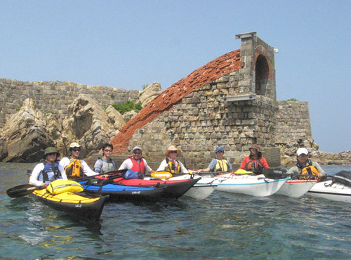
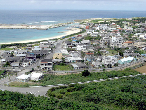 Sonai village, Yonaguni's main town, later on the morning of our arrival.
As we feel the intense pull of the beach now only 200 meters away, we are met with a final challenge. A barge is actually leaving port, now at 4 in the morning! What the...! They are lighting up the whole place with floodlights and only our incredibly fortuitous timing and a random pile of tetrapods in the middle of the port enables us to sneak past undetected. We play a game of hide and seek around the pile as the barge slides by, its floodlights bright as daylight. If we let them, they could see us from a kilometer away! We read and heard there was no camping in Yonaguni, and that this rule was strictly enforced (both proved untrue and unfounded later), but would they go so far as to light up beaches at night to look for itinerant gypsies? Worse still, did our friends Chika and Saeko panic and call the authorities on the arrival of the storm? Crap! In any case, this was no time and place to be detected, under the best of circumstances. We wait, glued to the tetrapods like frightened fish, until the barge safely departs harbor and disappears into the stormy darkness. After that, we are on the beach in no time at all. Terra firma at last!
二百メートル離れたビーチの引力を感じながら突然、最後のチャレンジに会います。なんて、バージが、港を出ようとしています。こんな深夜の四時で!しかも、投光器で周りを照らしている。ただタイミングの運が信じられないように良かったから、そして、港の真ん中にブロックの固まりがあったから、私達は見られないように入った。 丸で猫と鼠の遊びのように、バージが外へ進むと、私達はブロックの固まりを回って隠れました。こんな協力の光で、もし出たら、一キロの距離からも見つけられます!与那国で、キャンプ等は厳しく禁じられていると読んで、その上に友達から聞いた(でも実はそうでも無い)。でも私達のようなヤンキーを掴む為に港を投光器で照らすまでの活動はありえないやろう。最悪の場合、もうしかして西表の友達は、嵐が来た時パニックして、警察や海上保安庁を呼んだか。クソ!とにかく、何も無くてもこんな夜の嵐の時はどうしても見かけられない方がいい。だから、ブロックの固まりの影で待ちます。バージはゆっくり、この灯台も無い港を出て、どんどん嵐と闇に消えます。そうすると、私達はあっと言う間にビーチに上がります。やっと足元に大地。
Labels: kayak expedition シーカヤック遠征